Cordova, Cebu
Cordova, officially the Municipality of Cordova (Cebuano: Lungsod sa Cordova; Tagalog: Bayan ng Cordova), is a 3rd class municipality in the province of Cebu, Philippines. According to the 2015 census, it has a population of 59,712 people. [3]
Cordova | |
|---|---|
| Municipality of Cordova | |
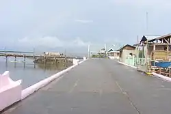 View along Day-As boardwalk | |
 Seal | |
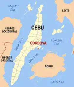 Map of Cebu with Cordova highlighted | |
OpenStreetMap 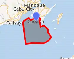
| |
.svg.png.webp) Cordova Location within the Philippines | |
| Coordinates: 10°15′N 123°57′E | |
| Country | |
| Region | Central Visayas (Region VII) |
| Province | Cebu |
| District | 6th District |
| Founded | 1864 |
| Barangays | 13 (see Barangays) |
| Government | |
| • Type | Sangguniang Bayan |
| • Mayor | Mary Therese S. Cho |
| • Vice Mayor | Ximgil Dino A. Sitoy |
| • Representative | Emmarie M. Ouano-Dizon |
| • Electorate | 39,163 voters (2019) |
| Area | |
| • Total | 17.15 km2 (6.62 sq mi) |
| Elevation | 2.0 m (6.6 ft) |
| Population | |
| • Total | 59,712 |
| • Density | 3,500/km2 (9,000/sq mi) |
| • Households | 13,167 |
| Economy | |
| • Income class | 3rd municipal income class |
| • Poverty incidence | 19.68% (2015)[4] |
| • Revenue | ₱130,062,371.57 (2016) |
| Time zone | UTC+8 (PST) |
| ZIP code | 6017 |
| PSGC | |
| IDD : area code | +63 (0)32 |
| Climate type | tropical monsoon climate |
| Native languages | Cebuano Tagalog |
| Website | cordova |
Also spelled Cordoba, most of the municipality lies on separate islands off the southern coast of Mactan Island. It is connected to the main island of Mactan by two bridges with a third to be opened by 2021.[5][6]
Cordova is bordered to the north by the city of Lapu-Lapu, to the west is the Mactan Channel, to the east is Hilutangan Channel and Olango Island, and to the south is the Cebu Strait.
Cordova lies within Metro Cebu.
History
On 22 May 1863, the Spanish Governor General of the Philippines Rafael Echagüe y Bermingham (1815-1887) created a new town comprising the barrios of Gabi, Day‑as and Pilipul (now called Pilipog), all of which are located on the southeastern tip of Mactan Island. Some authors think he chose the name Cordoba which means "stark nakedness and bare", but they do not indicate in what language. The decree of becoming a municipality only became effective in 1864.
However, before being appointed Governor General, in 1858, Rafael Echagüe y Bermingham was representative in the Spanish Congress of Deputies for the province of Cordoba (Spain), so he should have given that name in memory of his previous experiences.
In addition to Spain and the Philippines, there are other cities or provinces named Cordoba, Cordova or Las Cordobas in Argentina, Colombia, USA and Mexico, all of them founded and named by Spanish, in memory of the Spanish Cordoba or the surname/family name of its founders.
Cordova became a municipality in 1864, and from 1913 up to the present, a total of 15 mayors governed the district.
The Cebu–Cordova Link Expressway, which is set to be completed by 2021, will connect Cebu City in mainland Cebu to the town. This will be the third bridge connecting mainland Cebu to Mactan Island, after the Mactan–Mandaue Bridge and the Marcelo Fernan Bridge.[7][8]
Geography
Geographically, Cordova consists of a main island, bordering on and separated from Mactan Island by a narrow stream, as well as the islets of Gilutongan (also spelled Hilutungan), Nalusuan, Shell, Tongo and Lava. The two islets of Gilutongan and Nalusuan are part of the Olango Island Group in the middle of the Cebu Strait. Its land area is 789.6 hectares (1,951 acres), of which 740.85 hectares (1,830.7 acres) constitutes the main island and 48.75 hectares (120.5 acres) are outlying islets.[9]
The surface of the town consists entirely of karstic limestone rock geologically associated with the Plio-Pleistocene Carcar Formation, dated to 2½–3 million years ago. The topography of Cordova is flat land, the highest point being only 10 metres (33 ft) above sea level.[9]
A PRIVATE firm is set to build a Mangrove Propagation and Information Center in Barangay Day-as in the town of Cordova, a facility that will help the local government protect its mangroves. Metro Pacific Investments Foundation (MPIF), the corporate social responsibility (CSR) arm of Metro Pacific Investments Corp. (MPIC), will build the center in the middle of a 500-square-meter mangrove plantation in Barangay Day-as. Cordova has at least two hectares of mangroves that surround several of its barangays.[10]
Climate
| Cordova Average annual temperature in Cordova is 27·6°C Humidity 75–85% | ||||||||||||||||||||||||||||||||||||||||||||||||||||||||||||
|---|---|---|---|---|---|---|---|---|---|---|---|---|---|---|---|---|---|---|---|---|---|---|---|---|---|---|---|---|---|---|---|---|---|---|---|---|---|---|---|---|---|---|---|---|---|---|---|---|---|---|---|---|---|---|---|---|---|---|---|---|
| Climate chart (explanation) | ||||||||||||||||||||||||||||||||||||||||||||||||||||||||||||
| ||||||||||||||||||||||||||||||||||||||||||||||||||||||||||||
| ||||||||||||||||||||||||||||||||||||||||||||||||||||||||||||
The climate of Cordova is of Coronas type III, meaning the seasons are not very pronounced and are classified as hot and humid.
Its temperature ranges from 18 to 35 °C (65 to 95 °F), with a mean high temperature of 31 °C (88 °F) and a mean low of 23 °C (74 °F).[9]
Barangays
Cordova comprises 13 barangays:
| PSGC | Barangay | Population | ±% p.a. | |||
|---|---|---|---|---|---|---|
| 2015 [3] | 2010 [11] | |||||
| 072220001 | Alegria | 5.9% | 3,540 | 2,874 | 4.05% | |
| 072220002 | Bangbang | 8.9% | 5,287 | 4,325 | 3.90% | |
| 072220003 | Buagsong | 6.6% | 3,936 | 3,350 | 3.12% | |
| 072220004 | Catarman | 7.7% | 4,596 | 3,741 | 4.00% | |
| 072220005 | Cogon | 4.5% | 2,715 | 2,585 | 0.94% | |
| 072220006 | Dapitan | 5.3% | 3,149 | 2,993 | 0.97% | |
| 072220007 | Day‑as | 7.1% | 4,241 | 3,617 | 3.08% | |
| 072220008 | Gabi | 7.9% | 4,713 | 3,478 | 5.96% | |
| 072220009 | Gilutongan | 2.7% | 1,640 | 1,442 | 2.48% | |
| 072220010 | Ibabao | 14.0% | 8,355 | 6,949 | 3.57% | |
| 072220011 | Pilipog | 7.2% | 4,273 | 3,642 | 3.09% | |
| 072220012 | Poblacion | 16.1% | 9,625 | 8,603 | 2.16% | |
| 072220013 | San Miguel | 6.1% | 3,642 | 2,754 | 5.47% | |
| Total | 59,712 | 50,353 | 3.30% | |||
Demographics
|
| |||||||||||||||||||||||||||||||||||||||||||||
| Source: Philippine Statistics Authority [3] [11] [12][13] | ||||||||||||||||||||||||||||||||||||||||||||||
Tourism
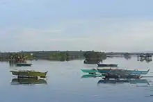
Cordova is a quiet fisherman town off the coast of mainland Cebu. It has several hotels, resorts and accommodations, which include:
- Gilutongan Marine Sanctuary
- Nalusuan Marine Sanctuary
- Day‑as Boardwalk and Marine Park
- Kamampay Public Beach
- Shey Residence in Buagsong, Cordova
A special attraction is the mangrove forest and swamp area. The best access to this area is the Day-as Boardwalk and Marine Park. The total mangrove plantation is estimated to cover more or less one hundred hectares (250 acres). Most of the mangrove forest is located in the barangays of Pilipog, Bangbang, San Miguel, Day‑as and Catarman.
Education
The children in Cordova are served by 14 day-care centers, eleven public elementary schools, two private elementary schools, one public high school, a private high school and the public college. Educational achievement is relatively high, with 75% of adults (i.e. 21 years old and above) having finished elementary and high school and 23% have attended university or received a degree. Around 2% of the population report not having received formal schooling.
See also
References
- Municipality of Cordova | (DILG)
- "Province: Cebu". PSGC Interactive. Quezon City, Philippines: Philippine Statistics Authority. Retrieved 12 November 2016.
- Census of Population (2015). "Region VII (Central Visayas)". Total Population by Province, City, Municipality and Barangay. PSA. Retrieved 20 June 2016.
- "PSA releases the 2015 Municipal and City Level Poverty Estimates". Quezon City, Philippines. Retrieved 12 October 2019.
- Cebu Daily News 2016.
- Philippine Star 2016.
- Cebu Daily News 2018.
- Philippine Star 2018.
- "Physical Profile". www.cordova.gov.ph. Municipality of Cordova. 2016. Retrieved 25 February 2016.
- http://www.sunstar.com.ph/cebu/local-news/2018/03/03/bridge-project-comes-assistance-cordovas-mangroves-591698
- Census of Population and Housing (2010). "Region VII (Central Visayas)". Total Population by Province, City, Municipality and Barangay. NSO. Retrieved 29 June 2016.
- Censuses of Population (1903–2007). "Region VII (Central Visayas)". Table 1. Population Enumerated in Various Censuses by Province/Highly Urbanized City: 1903 to 2007. NSO.
- "Province of Cebu". Municipality Population Data. Local Water Utilities Administration Research Division. Retrieved 17 December 2016.
Sources
- Cebu Daily News, Jessie D. Campos (27 January 2016). "Cordova, Metro Pacific ink deal for 3rd Mactan bridge". Archived from the original on 20 January 2016.CS1 maint: ref=harv (link)
- Gonzales, Glenda R. (December 2004). "Metro Cebu: A Metropolitan Area in Need of Coordinative Body" (PDF). Discussion Paper. 2004-49. PIDS. Archived (PDF) from the original on 10 March 2016. Retrieved 16 February 2016.CS1 maint: ref=harv (link)
- Philippine Star, Marieta Reyes (2 May 2016). "Cebu-Cordova bridge to boost Central Visayas economy". Archived from the original on 2 May 2016.CS1 maint: ref=harv (link)
- Sotto, Filipina; Gatus, Joey; Ross, Michael; Portigo, Ma Fe; Freire, Francis (2001). Coastal Environmental Profile of Olango Island, Cebu, Philippines (PDF). ISBN 971-9229012.CS1 maint: ref=harv (link)
External links
| Wikivoyage has a travel guide for Cordova. |
Places adjacent to Cordova, Cebu | ||||||||||
|---|---|---|---|---|---|---|---|---|---|---|
| ||||||||||
Cebu City (capital) | |
| Municipalities |
|
| Component cities | |
| Highly urbanized cities | (Administratively independent from the province but grouped under Cebu by the Philippine Statistics Authority. However, qualified voters in Mandaue are allowed to vote in elections for Cebu provincial officials by virtue of Republic Act No. 6641, in accordance with Section 452-c of the Local Government Code of 1991.) |
| Authority control |
|
|---|