Dorchester Parish, New Brunswick
Dorchester is a civil parish in Westmorland County, New Brunswick, Canada.[2]
Dorchester | |
|---|---|
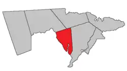 Location within Westmorland County, New Brunswick. | |
| Coordinates: 46.19°N 64.60°W | |
| Country | |
| Province | |
| County | Westmorland County |
| Erected | 1787 |
| Area | |
| • Land | 90.13 km2 (34.80 sq mi) |
| Population (2016)[1] | |
| • Total | 429 |
| • Density | 4.8/km2 (12/sq mi) |
| • Change 2011-2016 | |
| • Dwellings | 231 |
| Time zone | UTC-4 (AST) |
| • Summer (DST) | UTC-3 (ADT) |
For governance purposes it is divided between the city of Dieppe;[3] the villages of Dorchester and Memramcook;[3] the Indian reserve of Fort Folly 1; and the local service district of the parish of Dorchester,[4] which further includes the special services area of Calhoun Road.
All governance units except the Indian reserve are members of the Southeast Regional Service Commission.[5]
Origin of name
The parish was named in honour of the Baron of Dorchester,[6] Governor General of British North America at the time and elder brother of Thomas Carleton, Governor of New Brunswick.
History
Dorchester was erected in 1787 from unassigned territory between Moncton and Sackville Parishes.[7] The parish included parts of modern Moncton, Sackville, and Shediac Parishes.
In 1827 part of Dorchester was included in the newly erected Shediac Parish.[8]
In 1835 all of Dorchester north of a line due east from the mouth of Fox Creek was transferred to Moncton Parish.[9]
In 1894 northern line was changed to a magnetic bearing running 6° 15' south of due east.[10] The 1894 boundaries were made retroactive to the erection of the parish.
Delineation
Dorchester Parish is defined in the Territorial Division Act[2] as being bounded:
- West by Petitcodiac River; north by a line running by the magnet of eighteen hundred and ninety-four; south eighty-three degrees and forty-five minutes east from the mouth of Fox Creek; east by the southeast line of lot numbered one (John Sherwood) and the prolongation thereof two hundred and fifty chains from the sea; thence north eleven degrees east by the magnet of the year seventeen hundred and sixty-five.
Communities
Parish population total does not include incorporated municipalities (in bold):
Demographics
Population
|
LanguageMother tongue (2016)[1]
| |||||||||||||||||||||||||||||||||||||||
Access routes
Highways and numbered routes that run through the parish, including external routes that start or finish at the parish limits:[13]
|
|
|
|
See also
References
- "Census Profile, 2016 Census: Dorchester, Parish [Census subdivision], New Brunswick". Statistics Canada. Retrieved October 5, 2019.
- "Chapter T-3 Territorial Division Act". Government of New Brunswick. Retrieved 13 November 2020.
- "New Brunswick Regulation 85-6 under the Municipalities Act (O.C. 85-45)". Government of New Brunswick. Retrieved 23 July 2020.
- "New Brunswick Regulation 84-168 under the Municipalities Act (O.C. 84-582)". Government of New Brunswick. Retrieved 23 July 2020.
- "Communities in each of the 12 Regional Service Commissions (RSC) / Les communautés dans chacune des 12 Commissions de services régionaux (CSR)" (PDF), Government of New Brunswick, July 2017, retrieved 1 February 2021
- Ganong, William F. (1896). A Monograph of the Place-Nomenclature of the Province of New Brunswick. Royal Society of Canada. p. 230.
- "27 Geo. III Chapter VII. An Act in Addition to an Act for the better ascertaining and confirming the Boundaries of the several Counties within this Province, and for Subdividing them into Towns or Parishes.". Acts of the General Assembly, of His Majesty's Province of New-Brunswick, Passed in the Year 1787. Saint John, New Brunswick: Government of New Brunswick. 1787. p. 147.
- "8 Geo. IV c. 13 An Act to erect the North-eastern part of the County of Westmoreland into a distinct Town or Parish, and also to authorize the appointment of Parish Officers at the November General Sessions in each year.". Acts of the General Assembly of His Majesty's Province of New-Brunswick, Passed in the Year 1827. Fredericton: Government of New Brunswick. 1827. pp. 28–30.
- "5 Wm. IV c. 15 An Act to alter the boundary line between certain Parishes in the County of Westmorland.". Acts of the General Assembly of His Majesty's Province of New-Brunswick, Passed in the Year 1835. Fredericton: Government of New Brunswick. 1835. p. 27.
- "57 Vic. c. 36 An Act to amend Chapter 2 of the Consolidated Statutes, of 'The division of the Province into Counties, Towns and Parishes,' so far as relates to the County of Westmorland.". Acts of the General Assembly of Her Majesty's Province of New Brunswick. Passed in the Month of April, 1894. Fredericton: Government of New Brunswick. 1894. pp. 162–163.
- Statistics Canada: 2001, 2006 census
- 2011 Statistics Canada Census Profile: Dorchester Parish, New Brunswick
- Atlantic Canada Back Road Atlas ISBN 978-1-55368-618-7
Places adjacent to Dorchester Parish, New Brunswick | |
|---|---|
| Subdivisions | |
|---|---|
| Cities | |
| Counties | |
| |
