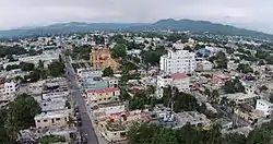
San Cristóbal, Dominican Republic
San Cristóbal[4] is a municipality (municipio) and the capital of the San Cristóbal province in the Dominican Republic. Within the municipality there is one municipal district (distrito municipal): Hato Damas.[5]
San Cristóbal | |
|---|---|
 | |
 Seal | |
| Nickname(s): Cuna de la Constitución, Provincia Benemérita | |
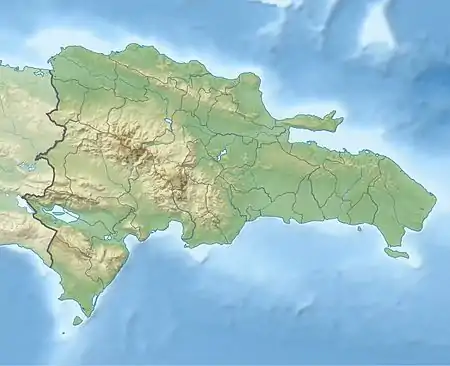 San Cristóbal San Cristóbal in the Dominican Republic | |
| Coordinates: 18°25′00″N 70°06′20″W | |
| Country | |
| Province | San Cristóbal |
| Government | |
| • Mayor of San Cristóbal | Jose Nelson Guillén Valdez |
| • Senator of San Cristobal | Tommy Galán |
| • Governor of San Cristobal | Julio Cesar Díaz |
| Area | |
| • Total | 226.52 km2 (87.46 sq mi) |
| Elevation | 33 m (108 ft) |
| Population (2012)[3] | |
| • Total | 275,232 |
| • Density | 1,200/km2 (3,100/sq mi) |
| • Demonym | Sancristobero(s) |
| Municipal Districts | 1 |
| Distance to – Santo Domingo | 26 km (16 mi) |
| Website | San Cristóbal website |
Sectors
- 5 de abril
- Canastica
- El Pomier
- Hatillo
- La Cruz
- La Guandulera
- La Suiza
- La Toma
- Las Flores
- Lava Pies
- Los Cacaitos
- Los Molinas
- Los Montones
- Los Corozos
- zona verde
- Los Novas
- Madre Vieja Norte
- Madre Vieja Sur
- Medina
- Moscú
- Pueblo Nuevo
- Sabana Toro
- Villa Fundación
- Villa Liberación
- Villa Valdez
- Zona Verde
- miracielo
- Villa Mercedes
- Las Arecas
- Villa Liveracion
- Najayo Arriba
- Yaguate
- Cambita
- Doña Ana
- Hatillo
- Nicole
- San Isidro
- Nigua
- Frank Reyna
History
San Cristóbal was founded in the late 16th century. Being the 3rd most important city in the country, its nickname "La Ciudad Benemerita" means "City deserving of grace". The Constitution of the Dominican Republic was signed in San Cristobal in 1844. Rafael Trujillo, dictator from 1930 to 1961; was born in San Cristobal in 1891 and killed by anti-dictatorial Dominicans on his way to San Cristobal in 1961 as part of a successful plot to end his 30-year authoritarian and fascist regime. Trujillo had several properties in San Cristobal among these were:
- El Castillo El Cerro
- La Casa de Playa de Najayo o Casa de Marfil
- La Hacienda María o Casa Blanca
- La Casa de Caoba (his favorite home)
All of these buildings are still standing, though in poor conditions. He built many monuments in his hometown, such as Balneario La Toma, and Parque Piedras Vivas- a park he ordered to be built from rocks and stones collected from each city of the Dominican Republic to honor himself (hence the park's name "Living Stones").
Geography
San Cristobal Is located about 30 kilometres (19 mi) on the DR-2 from Santo Domingo and close to Bajos de Haina. It's Located near the coast of the Caribbean Sea. The topography is hilly as you go farther inland into the Cordillera Central mountain range.
Climate
| Climate data for San Cristóbal, Dominican Republic (1961–1990) | |||||||||||||
|---|---|---|---|---|---|---|---|---|---|---|---|---|---|
| Month | Jan | Feb | Mar | Apr | May | Jun | Jul | Aug | Sep | Oct | Nov | Dec | Year |
| Average high °C (°F) | 29.6 (85.3) |
29.8 (85.6) |
30.6 (87.1) |
31.3 (88.3) |
31.3 (88.3) |
31.6 (88.9) |
32.2 (90.0) |
32.4 (90.3) |
32.4 (90.3) |
31.9 (89.4) |
31.1 (88.0) |
29.9 (85.8) |
31.2 (88.2) |
| Daily mean °C (°F) | 24.3 (75.7) |
24.4 (75.9) |
25.0 (77.0) |
25.9 (78.6) |
26.4 (79.5) |
26.9 (80.4) |
27.4 (81.3) |
27.4 (81.3) |
27.2 (81.0) |
26.8 (80.2) |
25.9 (78.6) |
24.8 (76.6) |
26.0 (78.8) |
| Average low °C (°F) | 19.1 (66.4) |
19.0 (66.2) |
19.5 (67.1) |
20.5 (68.9) |
21.4 (70.5) |
22.2 (72.0) |
22.6 (72.7) |
22.4 (72.3) |
21.9 (71.4) |
21.6 (70.9) |
20.8 (69.4) |
19.7 (67.5) |
20.9 (69.6) |
| Average rainfall mm (inches) | 60.9 (2.40) |
51.1 (2.01) |
52.9 (2.08) |
72.4 (2.85) |
218.1 (8.59) |
214.8 (8.46) |
148.3 (5.84) |
202.5 (7.97) |
187.5 (7.38) |
210.5 (8.29) |
111.6 (4.39) |
68.8 (2.71) |
1,599.4 (62.97) |
| Average rainy days (≥ 1.0 mm) | 6.8 | 5.9 | 6.9 | 7.5 | 13.7 | 12.4 | 11.3 | 11.9 | 11.2 | 12.8 | 9.1 | 8.1 | 117.6 |
| Average relative humidity (%) | 76.3 | 75.1 | 72.6 | 71.9 | 76.9 | 78.2 | 76.2 | 76.7 | 77.3 | 79.5 | 77.5 | 77.0 | 76.3 |
| Source: NOAA[6] | |||||||||||||
Economy
Goya Foods has its Dominican Republic offices in San Cristóbal.[7]
Notable residents
- Miguel Andújar, third baseman for the New York Yankees
- Santiago Casilla, relief pitcher for the Oakland Athletics
- José Guillén, former outfielder in Major League Baseball
- Francisco Liriano, pitcher for the Detroit Tigers
- Rigoberto Mendoza (born 1992), basketball player for Maccabi Haifa of the Israeli Basketball Premier League
- Raúl Mondesí, former All-Star and Gold Glove Major League outfielder, most notably for the Los Angeles Dodgers; former mayor of San Cristobal (2010-16)
- Temístocles Montás, president of the Dominican Liberation Party (PLD)
- Iván Nova, starting pitcher for the Pittsburgh Pirates
- Michael Pineda, right-handed pitcher for the Minnesota Twins
- Al Reyes, pitcher for the Milwaukee Brewers, Baltimore Orioles, Los Angeles Dodgers, Pittsburgh Pirates, New York Yankees, St. Louis Cardinals, and Tampa Bay Rays
- José Rijo, former right-handed pitcher in Major League Baseball who spent the majority of his career with the Cincinnati Reds
- Sixto Sánchez, starting pitcher in the Miami Marlins organization
- Ervin Santana, former starting pitcher for the Los Angeles Angels and Minnesota Twins
- Pedro Strop, relief pitcher for the Chicago Cubs[8]
- Rafael Leonidas Trujillo, former dictator of the Dominican Republic
Sites of interest
- Diego Caballero Sugar Mill
- La Toma de San Cristóbal
- Pomier Caves
- Parque Piedras Vivas
- Playa Palenque
- Playa Najayo
- Ingenio CAEI
- Fuerte Resoli.
References
- Superficies a nivel de municipios, Oficina Nacional de Estadistica Archived 2009-04-17 at the Wayback Machine
- De la Fuente, Santiago (1976). Geografía Dominicana Republicaaa (in Spanish). Santo Domingo, Dominican Republic: Editora Colegial Quisqueyana.
- Censo 2012 de Población y Vivienda, Oficina Nacional de Estadistica
- http://www.britannica.com/EBchecked/topic/521037/San-Cristobal
- Oficina Nacional de Estadistica, Departamento de Cartografia, Division de Limites y Linderos. "Listado de Codigos de Provincias, Municipio y Distritos Municipales, Actualizada a Junio 20 del 2006" (in Spanish). Archived from the original on 2007-03-14. Retrieved 2007-01-24.CS1 maint: multiple names: authors list (link)
- "San Cristobal Climate Normals 1961-1990". National Oceanic and Atmospheric Administration. Retrieved September 21, 2016.
- "Contact Us." Goya Foods. Retrieved on March 26, 2016. "Goya Foods of the Dominican Republic, S.A. Kilómetro 17 Autopista 6 de Noviembre San Cristóbal, Dominican Republic"
- https://www.baseball-reference.com/players/s/stroppe01.shtml