Saskatchewan Highway 11A
Highway 11A is a short freeway in the Canadian province of Saskatchewan serving the city of Regina. It runs from the Highway 6 at Regina's northern city limit to Highway 11, 7 km (4 mi) northwest of Regina. It is the original configuration for Highway 11 as it approached Regina and was designated after the Regina Bypass was opened in 2019.[2]
| ||||
|---|---|---|---|---|
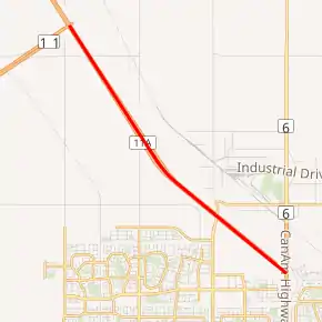
Highway 11A highlighted in red | ||||
| Route information | ||||
| Maintained by Ministry of Highways and Infrastructure & Transport Canada | ||||
| Length | 7.3 km[1] (4.5 mi) | |||
| Existed | 2019–present | |||
| Major junctions | ||||
| South end | ||||
| North end | ||||
| Location | ||||
| Rural municipalities | Sherwood No. 159 | |||
| Highway system | ||||
Provincial highways in Saskatchewan
| ||||
.svg.png.webp)
Highway 11 used to be signed through Regina along Albert Street and Ring Road to Victoria Avenue where it terminated at the Highway 1; however, the Highway 11A designation only pertains to the area outside city limits where it is under provincial jurisdiction.[2]
Exit list
From south to north. All exits are unnumbered.
| Rural municipality | Location | km[1] | mi | Destinations | Notes |
|---|---|---|---|---|---|
| City of Regina | −1.5 | −0.93 | Albert Street – City Centre | ||
| 0.0 | 0.0 | Northbound exit, southbound entrance | |||
| Sherwood No. 159 | | 2.0 | 1.2 | Pasqua Street | |
| 7.3 | 4.5 | Continues as Hwy 11 north; exit 19 on Hwy 11 | |||
1.000 mi = 1.609 km; 1.000 km = 0.621 mi
| |||||
References
- Google (December 7, 2019). "Highway 11A in Saskatchewan" (Map). Google Maps. Google. Retrieved December 7, 2019.
- "Highway Name Changes At The Regina Bypass". Government of Saskatchewan | News and Media. October 10, 2019. Archived from the original on October 10, 2019. Retrieved December 7, 2019.
External links
This article is issued from Wikipedia. The text is licensed under Creative Commons - Attribution - Sharealike. Additional terms may apply for the media files.