Saskatchewan Highway 711
Saskatchewan Highway 711 connects Saskatchewan Highway 35 in the Wellington rural municipality (RM) to Saskatchewan Highway 9 in the Wawken RM. The beginning terminus is just south of Cedoux. The length of Highway 711 is 142.1 kilometres (88.3 mi) and it extends westward, in the south-eastern area of Saskatchewan northeast of Weyburn. Osage and Corning are the only communities along the route.[1]
| Communities |
|---|
| ||||
|---|---|---|---|---|
 | ||||
| Route information | ||||
| Maintained by Ministry of Highways and Infrastructure & RMs listed | ||||
| Length | 142.1 km[1] (88.3 mi) | |||
| Major junctions | ||||
| West end | ||||
| East end | ||||
| Location | ||||
| Rural municipalities | Wellington, Fillmore, Golden West, Hazelwood, Wawken | |||
| Highway system | ||||
Provincial highways in Saskatchewan
| ||||

Rural municipalities
Wellington has a population of about 372 in a mainly agricultural community.[2] Fillmore has a similar population about 308.[3] Golden West locates its head office in Corning, the entire RM population is 344.,[4] Moose Mountain Provincial Park is within the RM of Hazelwood, a RM with a population of 308.[5] Wawken has the largest population along the highway with 643 residents.[6]
Travel Route
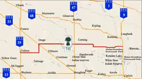
Cedoux is north of the milepost 0. Highway 711 starts out westerly in the southeastern portion of the province. AT Km 20.4, the highway sharply turns north continuing north for 20.3 kilometres (12.6 mi). At Km 29.5, Highway 711 arrives at Osage and the junction with Highway 33. There is a 0.7 kilometres (0.43 mi) concurrency with Highway 619 along the eastern edge of town. At Km 30.1, Highway 711 turns east again departing from the concurrency. The intersection with Highway 606 occurs at Km 40.0. At Km 61.1, Highway 711 is the junction with Highway 617 North. Highway 617 provides access to Glenavon. At Km 69.3, Highway 711 meets with the intersection of Highway 47. Travelling south on Highway 47 is the town of Stoughton. Travel on Highway 711 continues east and at Km 73.4 the highway arrives at Corning. Leaving Corning east there is a sharp turn south at Km 90.4. The highway resumes its easterly course and meets with intersection Highway 605 at Km 101.8. The ending terminus of Highway 711 is at Saskatchewan Highway 9 north of Moose Mountain Provincial Park and the town of Kenosee Lake. Travel north on Highway 9 to arrive at Langbank.[1]
Intersections
| Rural municipality | Location | km[7] | mi | Destinations | Notes |
|---|---|---|---|---|---|
| Wellington No. 97 | 0 | 0.0 | Beginning terminus south of Cedoux | ||
| Fillmore No. 96 | 20.4 | 32.8 | |||
| Osage | 29.5 | 47.5 | Sk Hwy 33 Northwest to Francis, southeast to Fillmore | ||
| 30.1 | 48.4 | Concurrency with Highway 619 ends. | |||
| 40.0 | 64.4 | . | |||
| Golden West No. 95 | 61.1 | 98.3 | |||
| 69.3 | 111.5 | ||||
| Corning | 73.4 | 118.1 | |||
| Hazelwood No. 94 | 90.4 | 145.5 | |||
| Wawken No. 93 | 101.8 | 163.8 | |||
| 142.1 | 228.7 | Ending terminus north of Moose Mountain Provincial Park | |||
| 1.000 mi = 1.609 km; 1.000 km = 0.621 mi | |||||
External links
- Osage One Room School House, Saskatchewan, Canada
- Grain Elevators - Osage Saskatchewan Grain Elevator
- 2006 Agriculture Community Profiles Wellington No. 97
- Agriculture Community Profiles Fillmore No. 96
- Agriculture Community Profiles Golden West No. 95
- 2006 Agriculture Community Profiles Hazelwood No. 94
- 2006 Agriculture Community Profiles Wawken No. 93
References
- Microsoft Streets and Tips (Map) (2004 ed.). Microsoft Corp. § Route Planner.
|access-date=requires|url=(help) - "Wellington No. 97", SaskBiz, Government of Saskatchewan, November 1, 1995, retrieved 2009-01-11
- "Fillmore No. 96, Saskatchewan", SaskBiz, Government of Saskatchewan, November 1, 1995, retrieved 2009-01-11
- "Golden West No. 95, Saskatchewan", SaskBiz, Government of Saskatchewan, November 1, 1995, retrieved 2009-01-11
- "Hazelwood No. 94, Saskatchewan", SaskBiz, Government of Saskatchewan, November 1, 1995, retrieved 2009-01-11
- "Wawken No. 93, Saskatchewan", SaskBiz, Government of Saskatchewan, November 1, 1995, retrieved 2009-01-11
- Microsoft Streets and Tips (Map) (2004 ed.). Microsoft Corporation Redmond Washington. Check date values in:
|access-date=(help);|access-date=requires|url=(help)