Saskatchewan Highway 4
Highway 4 is a major highway in the Canadian province of Saskatchewan. It runs from U.S. Route 191 at the United States border near Monchy to Highway 224 / Highway 904 in Meadow Lake Provincial Park. Highway 4 is about 652 km (405 mi) long.[1]
| ||||
|---|---|---|---|---|
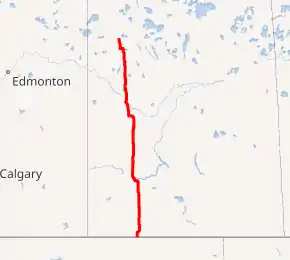
Highway 4 highlighted in red. | ||||
| Route information | ||||
| Maintained by Saskatchewan Ministry of Highways and Infrastructure | ||||
| Length | 652.2 km[1] (405.3 mi) | |||
| Major junctions | ||||
| South end | ||||
| ||||
| North end | ||||
| Location | ||||
| Major cities | Swift Current, North Battleford, Meadow Lake | |||
| Towns | Rosetown, Biggar, Battleford | |||
| Highway system | ||||
Provincial highways in Saskatchewan
| ||||
.svg.png.webp)
Major communities that Highway 4 passes through are Swift Current, Rosetown, Biggar, Battleford, North Battleford, and Meadow Lake. It also passes The Battlefords Provincial Park.
History
Highway 4 was originally designated as Provincial Highway 1, while the present-day Highway 1 was designated as Provincial Highway 4.[2] The designations were switched around c. 1940 to allow for the future Trans-Canada Highway to have the same number across western Canada.[3]
Highway 4S
Several maps, such as MapArt's mapbook of Saskatchewan Cities and Towns shows a Highway 4S spur heading east from the intersection of Highway 4 in Swift Current to the city's airport, following Airport Road.[4] The roadway is not designated Highway 4S on the Saskatchewan Highway's Official Highway Map.[5][6]
Gallery

 Highway 4 south of Swift Current, northbound
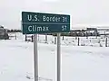 Sign on Highway 4 in Val Marie
Major intersections
From south to north:[7]
| Rural municipality | Location | km[1] | mi | Destinations | Notes |
|---|---|---|---|---|---|
| Val Marie No. 17 | Monchy | 0.0 | 0.0 | Continuation into Montana | |
| Canada–United States border at Morgan–Monchy Border Crossing | |||||
| | 16.4 | 10.2 | South of Masefield; south end of Hwy 18 concurrency | ||
| | 25.6 | 15.9 | |||
| Val Marie | 31.2 | 19.4 | North end of Hwy 18 concurrency | ||
| Wise Creek No. 77 | | 76.2 | 47.3 | ||
| Cadillac | 85.9 | 53.4 | |||
| Lac Pelletier No. 107 | | 112.2 | 69.7 | ||
| | 118.7 | 73.8 | |||
| Swift Current No. 137 | | 128.4 | 79.8 | ||
| | 141.3 | 87.8 | |||
| City of Swift Current | 148.1 | 92.0 | South Railway Street / Airport Road | Unofficial Hwy 4S | |
| 148.5 | 92.3 | Chaplin Street E – City Centre | |||
| 150.9 | 93.8 | Interchange | |||
| 152.4 | 94.7 | ||||
| Saskatchewan Landing No. 167 | | 171.9 | 106.8 | ||
| Stewart Valley | 185.6 | 115.3 | South end of Hwy 738 concurrency | ||
| | 192.3 | 119.5 | North end of Hwy 738 concurrency | ||
| ↑ / ↓ | Saskatchewan Landing Provincial Park | 199.8 | 124.1 | Saskatchewan Landing Bridge across Lake Diefenbaker (South Saskatchewan River) | |
| Lacadena No. 228 | | 224.9 | 139.7 | North of Kyle | |
| | 239.6 | 148.9 | |||
| Monet No. 257 | | 261.5 | 162.5 | ||
| Elrose | 264.7 | 164.5 | South end of Hwy 44 concurrency | ||
| | 268.0 | 166.5 | North end of Hwy 44 concurrency | ||
| | 271.3 | 168.6 | |||
| St. Andrews No. 287 | | 297.7 | 185.0 | ||
| Rosetown | 302.6 | 188.0 | |||
| Marriott No. 317 | | 314.3 | 195.3 | ||
| Marriott | 330.5 | 205.4 | |||
| Biggar No. 347 | Biggar | 359.9 | 223.6 | ||
| 361.0 | 224.3 | South end of Hwy 14 concurrency | |||
| 362.0 | 224.9 | North end of Hwy 14 concurrency | |||
| Glenside No. 377 | | 390.9 | 242.9 | South end of Hwy 784 concurrency | |
| Rosemount No. 378 | Cando | 409.4 | 254.4 | ||
| Buffalo No. 409 | | 417.1 | 259.2 | North end of Hwy 784 concurrency | |
| Battle River No. 438 | | 448.3 | 278.6 | ||
| | 448.5 | 278.7 | Crosses Battle River | ||
| Town of Battleford | 450.7 | 280.1 | South end of Hwy 40 concurrency; former Hwy 16A east | ||
| 452.6 | 281.2 | Interchange; south end of Hwy 16 concurrency | |||
| ↑ / ↓ | 453.4 | 281.7 | Battlefords Bridge over North Saskatchewan River | ||
| City of North Battleford | 454.3 | 282.3 | Interchange; northbound exit, southbound entrance; north end of Hwy 16 / Hwy 40 concurrency; south end of Hwy 16B concurrency | ||
| 455.1 | 282.8 | North Battleford bypass via Territorial Drive. | |||
| 455.5 | 283.0 | 11 Avenue | North end of Hwy 16B concurrency | ||
| 457.5 | 284.3 | North Battleford bypass | |||
| North Battleford No. 437 | | 463.1 | 287.8 | ||
| Meota No. 468 | | 472.8 | 293.8 | ||
| | 476.1 | 295.8 | |||
| | 482.6 | 299.9 | Metinota Access Road | Road accesses the south shore of Jackfish Lake | |
| Cochin | 490.0 | 304.5 | South end of Hwy 769 concurrency | ||
| The Battlefords Provincial Park | 493.4 | 306.6 | Access road | ||
| | 497.7 | 309.3 | North end of Hwy 769 concurrency | ||
| Parkdale No. 498 | | 513.1 | 318.8 | South end of Hwy 794 concurrency | |
| | 519.6 | 322.9 | North end of Hwy 794 concurrency | ||
| Glaslyn | 522.0 | 324.4 | South end of Hwy 3 concurrency | ||
| 523.5 | 325.3 | North end of Hwy 3 concurrency | |||
| Meadow Lake No. 588 | | 605.8 | 376.4 | ||
| City of Meadow Lake | 611.9 | 380.2 | South end Hwy 55 concurrency | ||
| Meadow Lake No. 588 | | 621.7 | 386.3 | North end Hwy 55 concurrency | |
| | 638.1 | 396.5 | Crosses Beaver River | ||
| Dorintosh | 645.0 | 400.8 | |||
| Meadow Lake Provincial Park | 652.2 | 405.3 | Northern terminus | ||
1.000 mi = 1.609 km; 1.000 km = 0.621 mi
| |||||
References
- Google (January 30, 2018). "Highway 4 in Saskatchewan" (Map). Google Maps. Google. Retrieved January 30, 2018.
- Province of Saskatchewan (1926). Highway Map (Map). Department of Highways.
- Rand McNally (1940). Road map of Western and Central Canada (Map). Rand McNally and Company.
- MapArt (2007). Saskatchewan Street Atlas (Map) (2007 ed.). 1:21,740. Oshawa, ON: Peter Heiler Ltd. p. 49. ISBN 1-55368-020-0.
- Province of Saskatchewan (2016). Saskatchewan Official Road Map (Map). § C2.
- Province of Saskatchewan (2016). Saskatchewan Official Road Map (Map). Swift Current inset.
- MapArt (2007). Saskatchewan Road Atlas (Map) (2007 ed.). 1:540,000. Oshawa, ON: Peter Heiler Ltd. pp. 11, 17, 23, 31, 39, 47, 48. ISBN 1-55368-020-0.
External links
| Wikimedia Commons has media related to Saskatchewan Highway 4. |