Saskatchewan Highway 15
Highway 15 is a highway in the Canadian province of Saskatchewan. It runs from Highway 4, 5 km (3 mi) south of Rosetown, to Highway 16, 4 km (2 mi) southeast of Bredenbury. Highway 15 is about 450 km (280 mi) long.[1] The Outlook Bridge carries Highway 15 across the South Saskatchewan River.
| ||||
|---|---|---|---|---|
| Route information | ||||
| Length | 449.6 km[1] (279.4 mi) | |||
| Major junctions | ||||
| West end | ||||
| East end | ||||
| Location | ||||
| Major cities | Melville | |||
| Towns | Outlook, Nokomis, Raymore, Ituna | |||
| Highway system | ||||
Provincial highways in Saskatchewan
| ||||
.svg.png.webp)
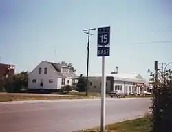
Saskatchewan Highway 15 passes through Melville, circa 1991.

Outlook Bridge (Highway 15) bridge near Outlook
Major communities serviced by Highway 15 are Outlook and Melville. The highway parallels the main line of the Canadian National Railway between Nokomis and Melville.
Major Intersections
From west to east:[2]
| Rural municipality | Location | km[1] | mi | Destinations | Notes | |||
|---|---|---|---|---|---|---|---|---|
| St. Andrews No. 287 | | 0.0 | 0.0 | Hwy 15 western terminus | ||||
| Sovereign | 17.8 | 11.1 | ||||||
| Milden No. 286 | Milden | 34.5 | 21.4 | |||||
| | 36.1 | 22.4 | ||||||
| Fertile Valley No. 285 | | 44.3 | 27.5 | Bounty access road | ||||
| | 47.5 | 29.5 | ||||||
| | 52.4 | 32.6 | Conquest access road | |||||
| | 60.5 | 37.6 | West end of Hwy 45 concurrency | |||||
| | 62.1 | 38.6 | East end of Hwy 45 concurrency | |||||
| ↑ / ↓ | | 64.1 | 39.8 | Outlook Bridge crosses the South Saskatchewan River | ||||
| Rudy No. 284 | Outlook | 66.8 | 41.5 | Saskatchewan Avenue / McKenzie Street | Hwy 15 branches east | |||
| Broderick | 76.9 | 47.8 | ||||||
| | 85.4 | 53.1 | ||||||
| Rosedale No. 283 | | 100.0 | 62.1 | |||||
| McCraney No. 282 | Kenaston | 122.7 | 76.2 | |||||
| | 144.8 | 90.0 | ||||||
| Wood Creek No. 281 | | 179.0 | 111.2 | |||||
| Wreford No. 280 | Nokomis | 209.9 | 130.4 | Hwy 15 branches south; west end of Hwy 20 concurrency | ||||
| | 219.6 | 136.5 | Hwy 15 branches east; east end of Hwy 20 concurrency | |||||
| Mount Hope No. 279 | | 239.1 | 148.6 | |||||
| Raymore | 252.2 | 156.7 | Hwy 15 branches south; west end of Hwy 6 concurrency | |||||
| | 254.8 | 158.3 | Hwy 15 branches east; east end of Hwy 6 concurrency | |||||
| Punnichy | 271.9 | 169.0 | West end of Hwy 640 concurrency | |||||
| | 273.8 | 170.1 | East end of Hwy 640 concurrency | |||||
| Kellross No. 247 | Lestock | 296.0 | 183.9 | |||||
| | 306.4 | 190.4 | East of Leross; west of Kelliher | |||||
| Ituna Bon Accord No. 246 | | 332.9 | 206.9 | Hwy 15 turns south; west end of Hwy 310 concurrency | ||||
| Ituna | 337.4 | 209.7 | Hwy 15 branches east; east end of Hwy 310 concurrency | |||||
| Tullymet No. 216 |
No major junctions | |||||||
| Stanley No. 215 | | 357.4 | 222.1 | West end of Hwy 617 concurrency | ||||
| Goodeve | 363.1 | 225.6 | East end of Hwy 617 concurrency | |||||
| City of Melville | 391.4 | 243.2 | ||||||
| 391.8 | 243.5 | Dielschneider Road / 3rd Avenue W | Hwy 15 branches south, then turns east and becomes 1st Avenue W | |||||
| 392.7 | 244.0 | Queen Street | Connects to Hwy 47 north | |||||
| Cana No. 214 | | 405.4 | 251.9 | |||||
| | 416.8 | 259.0 | ||||||
| Saltcoats No. 213 | | 433.1 | 269.1 | |||||
| | 446.1 | 277.2 | ||||||
| Saltcoats No. 213 | | 449.6 | 279.4 | Hwy 15 eastern terminus | ||||
1.000 mi = 1.609 km; 1.000 km = 0.621 mi
| ||||||||
References
- Google (February 14, 2018). "Highway 15 in Saskatchewan" (Map). Google Maps. Google.
- MapArt (2007). Saskatchewan Road Atlas (Map) (2007 ed.). 1:540,000. Oshawa, ON: Peter Heiler Ltd. pp. 31–35, 43–44. ISBN 1-55368-020-0.
This article is issued from Wikipedia. The text is licensed under Creative Commons - Attribution - Sharealike. Additional terms may apply for the media files.