Saskatchewan Highway 316
Highway 316 is a highway in the Canadian province of Saskatchewan. It runs from Highway 16 near Clavet to Highway 5. Highway 316 is about 17 km (11 mi.) long. This area is an industrial commercial area along Highway #316 which extends from Clavet north to the PCS Patience Lake Mine which is just 10 miles from the city of Saskatoon. Highway 316 is a primary weight highway, and also runs near the Canadian National Railway line which goes from Saskatoon through Clavet.[1] In 1941, the Canadian Pacific Railway ran from Saskatoon through Cheviot and on south eastward.[2]
| ||||
|---|---|---|---|---|
| Route information | ||||
| Length | 17 km (11 mi) | |||
| Major junctions | ||||
| South end | ||||
| North end | ||||
| Location | ||||
| Rural municipalities | Blucher No. 343 | |||
| Highway system | ||||
Provincial highways in Saskatchewan
| ||||
.svg.png.webp)

Highway 316 road sign located at Highway 16 or the Yellowhead Highway turn off
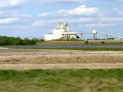
Potash Corporation of Saskatchewan (PCS) Patience Lake Mine north of Highway 16 or the Yellowhead Highway
Highway 316 passes near the community of Cheviot and intersects Highway 394.
Communities along the route
- Clavet is a village which can be found at 52°00′00″N 106°23′00″W or legal land description of Section 9 Township 35 Range 3 -West of the 3rd Meridian
- Cheviot, Saskatchewan, a small unincorporated area was the childhood home of Neil McArthur inducted into the Saskatchewan Agricultural Hall of Fame.[3] This area is located at 52°02′00″N 106°22′00″W or legal land description of Section 28 - Township 35- Range 3 -West of the 3rd Meridian
- Muskeg Lake First Nation Indian Reserve 102A
Rural municipalities along the route
- Blucher No. 343 is home to several industrial/commercial enterprises. Potash mining, anhydrous ammonia-bulk fertilizer distribution centres, canola crushing plant, as well as a large inland grain terminal.[4]
Major attractions
- Potash Corporation of Saskatchewan (PCS) Patience Lake Mine
- Cheviot Lake is located at 52°02′00″N 106°20′00″W or legal land description of Township 35 - Range 3 -West of the 3rd Meridian which is just east of Cheviot.
The following lakes are all north of Highway 316:
- Porter Lake 52°17′00″N 106°17′00″W or legal land description of Township 37- Ranges 2,3 - W of the 3rd Meridian[5]
- Patience Lake Is located at 52°07′00″N 106°20′00″W or legal land description of Township 36 - Range 3 -West of the 3rd Meridian
- Burke Lake is located at 52°10′00″N 106°18′00″W or legal land description of Township 37- Range 3 -West of the 3rd Meridian
References
- Sask Biz. "Community Profiles". Retrieved 2007-05-17.
- Canadian Online Map Digitization Project, J. Adamson. "1941 Waghorn's Map of Saskatchewan". rootsweb. Retrieved 2007-05-17.
- "Saskatchewan Agricultural Hall of Fame 1". Retrieved 2007-05-17.
- sask biz. "Community profiles". Retrieved 2007-05-15.
- Government of Canada. "Geonames Query". Retrieved 2007-05-15.
- Government of Canada. "Geonames Query". Retrieved 2007-05-15.
External links
This article is issued from Wikipedia. The text is licensed under Creative Commons - Attribution - Sharealike. Additional terms may apply for the media files.