Raja Ampat Islands
Raja Ampat, or the Four Kings, is an archipelago located off the northwest tip of Bird's Head Peninsula on the island of New Guinea, in Indonesia's West Papua province. It comprising over 1,500 small islands, cays, and shoals surrounding the four main islands of Misool, Salawati, Batanta, and Waigeo, and the smaller island of Kofiau.
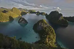 Panoramic view | |
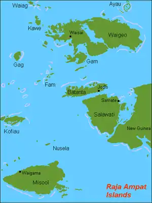 Map of the islands | |
 Raja Ampat Islands Location in Indonesia | |
| Geography | |
|---|---|
| Archipelago | Raja Ampat Islands |
| Total islands | 612 |
| Major islands | Misool Salawati Batanta Waigeo |
| Administration | |
Indonesia | |
| Province | West Papua |
| Regency | Raja Ampat Regency |
| Demographics | |
| Population | 50,000 (2018) |
The Raja Ampat archipelago straddles the Equator and forms part of Coral Triangle which contains the richest marine biodiversity on earth.
Administratively, the archipelago is part of the province of West Papua. Most of the islands constitute the Raja Ampat Regency, which was separated out from Sorong Regency in 2004. The regency encompasses around 70,000 square kilometres (27,000 sq mi) of land and sea, of which 7,559.6 km2 constitutes the land area and has a population of 47,885 (as of 2018). This excludes the southern half of Salawati Island, which is not part of this regency but instead constitutes the Salawati Selatan District of Sorong Regency.
History
The name of Raja Ampat (Raja means king, and empat means four) comes from local mythology that tells of a woman who finds seven eggs. Four of the seven hatch and become kings who occupy four of Raja Ampat's biggest islands whilst the other three become a ghost, a woman, and a stone.
History shows that Raja Ampat was once a part of the Sultanate of Tidore, an influential kingdom from Maluku. Yet, after the Dutch invaded Maluku, it was claimed by the Netherlands.
The first recorded sighting and landing by Europeans of the Ampat Islands was by the Portuguese navigator Jorge de Menezes and his crew in 1526, en route from Biak, the Bird's Head Peninsula, and Waigeo, to Halmahera (Ternate).
The English explorer William Dampier gave his name to Dampier Strait, which separates Batanta island from Waigeo island. To the east, there is a strait that separates Batanta from Salawati. In 1759 Captain William Wilson sailing in the East Indiaman Pitt navigated these waters and named a strait the 'Pitt strait', after his vessel; this was probably the channel between Batanta and Salawati.
Administration
Most of the islands make up the Raja Ampat Regency, a regency (kabupaten) forming part of West Papua Province. It came into existence in 2004, prior to which the archipelago was part of Sorong Regency.[1] The southern part of the island of Salawati is not part of the Raja Ampat Regency. Instead, it constitutes the Salawati Selatan District of Sorong Regency.
Raja Ampat Regency is subdivided into the following districts (kecamatan):
| Name | Area in km2 | Population Census 2010[2] | Population estimate mid-2018[3] | Administrative center |
|---|---|---|---|---|
| Misool Selatan (South Misool) | 91.16 | 3,026 | 4,175 | Dabatan |
| Misool Barat (West Misool) | 336.84 | 1,291 | 1,275 | Lilinta |
| Misool (or Misool Utara) | 1,235.68 | 1,761 | 1,751 | Salafen |
| Kofiau | 206.23 | 2,520 | 2,673 | Deer |
| Misool Timur (East Misool) | 553.66 | 2,651 | 3,204 | Folley |
| Kepulauan Sembilan (Sembilan Islands) | 17.21 | 1,458 | 2,019 | Weijim Barat |
| Raja Ampat Selatan | 2,440.78 | 12,707 | 15,097 | |
| Salawati Utara (North Salawati) | 38.52 | 2,144 | 2,317 | Samate |
| Salawati Tengah (Central Salawati) | 572.47 | 1,917 | 2,073 | Kalobo |
| Salawati Barat (West Salawati) | 502.47 | 899 | 972 | Solol |
| Batanta Selatan (South Batanta) | 188.77 | 1,312 | 1,422 | Yenanas |
| Batanta Utara (North Batanta) | 290.75 | 909 | 983 | Yensawai Timur |
| Raja Ampat Tengah | 1,592.98 | 7,181 | 7,767 | |
| Waigeo Selatan (South Salawati) | 240.12 | 1,715 | 1,923 | Saonek |
| Kota Waisai (Waisai Town) | 621.93 | 6,976 | 8,189 | Waisai |
| Teluk Mayalibit (Mayalibit Bay) | 218.87 | 846 | 912 | Yenanas |
| Tiplol Mayalibit | 121.87 | 930 | 1,005 | Go |
| Meosmansar | 200.51 | 1,625 | 1,792 | Yinbekwan |
| Waigeo Barat (West Waigeo) | 763.64 | 1,409 | 1,698 | Waisilip |
| Waigeo Barat Kepulauan (West Waigeo Islands) | 103.30 | 2,084 | 2,162 | Manyaifun |
| Waigeo Utara (North Waigeo) | 149.57 | 1,477 | 1,535 | Kabare |
| Warwarbomi | 297.33 | 1,045 | 946 | Warwanai |
| Supnin | 223.82 | 908 | 1,051 | Rauki |
| Kepulauan Ayau (Ayau Islands) | 12.66 | 1,230 | 1,031 | Abidon |
| Ayau | 5.83 | 989 | 1,280 | Dorehkar |
| Waigeo Timur (East Waigeo) | 555.40 | 1,386 | 1,493 | Urbinasopen |
| Raja Ampat Utara | 3,514.85 | 22,620 | 25,017 | |
| Total | 7,559.60 | 42,508 | 47,885 |
Taking account of the 2,635 people of Salawati Selatan District in Sorong Regency,[4] the total population of the archipelago adds up to just under 50,000.
There are proposals to divide the current Raja Ampat Regency into three, with Waigeo and its surrounding small islands forming a new North Raja Ampat Regency (Kabupaten Raja Ampat Utara), and with Misool and Kofiau and their surrounding small islands forming a new South Raja Ampat Regency (Kabupaten Raja Ampat Selatan), leaving the residue of the existing Regency to cover the northern part of Salawati Island (the rest of Salawati Island still lies within Sorong Regency) and Batanta Island (which forms Selat Sagawin District).
Population
The main occupation for people around this area is fishing since the area is dominated by the sea. They live in a small colony of tribes that spreads around the area. Although traditional culture still strongly exists, they are very welcoming to visitors. Raja Ampat people are more similar to the surrounding Moluccan people than Papuan people although they still speak Papuan language. The Muslim proportion is much higher compared with other Papuan areas. Although it has to be noted that West Papua province as a whole have larger Muslim population because of the extensive history with the Sultanate of Tidore as well as recent migrations.[5]
Geography
The oceanic natural resources around Raja Ampat give it significant potential as a tourist area. Many sources place Raja Ampat as one of their top ten most popular places for diving whilst it retains the number one ranking for underwater biodiversity.
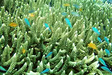
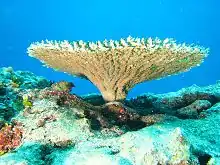
According to Conservation International, marine surveys suggest that the marine life diversity in the Raja Ampat area is the highest recorded on Earth.[6] Diversity is considerably greater than any other area sampled in the Coral Triangle composed of Indonesia, Malaysia, Philippines, Papua New Guinea, Solomon Islands, and East Timor. The Coral Triangle is the heart of the world's coral reef biodiversity, making Raja Ampat quite possibly the richest coral reef ecosystems in the world.
The area's massive coral colonies along with relatively high sea surface temperatures, also suggest that its reefs may be relatively resistant to threats like coral bleaching and coral disease, which now jeopardize the survival of other coral ecosystems around the world. The Raja Ampat islands are remote and relatively undisturbed by humans.
The crown-of-thorns starfish eats Raja Ampat's corals, and the destruction this causes among reefs has posed a threat to tourism. The crown-of-thorns starfish, which "can grow as big around as a trash-can lid", has proliferated due to increasing nitrogen in the water from human waste, which in turn causes a spike in phytoplankton on which the starfish feed.[7] In 2019, local divers had begun the task of reducing starfish populations by injecting the starfish with a 10% vinegar solution; the dead starfish can then be eaten by local fish.[7]
The high marine diversity in Raja Ampat is strongly influenced by its position between the Indian and Pacific Oceans, as coral and fish larvae are more easily shared between the two oceans. Raja Ampat's coral diversity, resilience, and role as a source for larval dispersal make it a global priority for marine protection.
1,508 fish species, 537 coral species (a remarkable 96% of all scleractinia recorded from Indonesia are likely to occur in these islands and 75% of all species that exist in the world[8]), and 699 mollusk species, the variety of marine life is staggering.[9] Some areas boast enormous schools of fish and regular sightings of sharks, such as wobbegongs.
Raja Ampat Islands have at least three ponds containing harmless jellyfish, all in the Misool area.[10]
Climate
The islands have a tropical climate, with temperatures ranging from 20 to 33 °C (68 to 91 °F).[11]
Water temperature in North Raja Ampat ranges 28° to 30°C (82° to 86°F) (Water temperature chart in North Raja Ampat), while in the South in Misool, it ranges 26° to 28°C (79° to 82°F) (Water temperature chart in Misool)
Ecology
Terrestrial
The islands are part of the Vogelkop-Aru lowland rain forests ecoregion.[12] The rain forests that covers the islands is the natural habitat of many species of birds, mammals, reptiles and insects. Two species of bird-of-paradise, the red bird-of-paradise (Paradisaea rubra) and Wilson's bird-of-paradise (Diphyllodes respublica), are endemic to the islands of Waigeo, Gam, and Batanta.[13]
Marine
Raja Ampat is considered the global center of tropical marine bio-diversity and is referred to as The Crown Jewel of the Bird's Head Seascape, which also includes Cenderawasih Bay and Triton Bay. The region contains more than 600 species of hard corals, equaling about 75 percent of known species globally, and more than 1,700 species of reef fish - including on both shallow [14] and mesophotic reefs.[15] Compared to similar-sized ecosystems elsewhere in the world, this makes Raja Ampat's biodiversity the richest in the world.[16] Endangered and rare marine mammals such as Dugongs, whales (such as blue or/and pygmy blue, bryde's, less known omura's,[17][18][19] sperm), dolphins, and orcas occur here.[20][21][22]
In northeast region of Waigeo island, local villagers have been involved in turtle conservation initiatives by protecting nests or relocating eggs of leatherback, olive ridley and hawksbill turtles. Their works are supported by local government, and NGOs.[23]
Recent events
The submarine world around the islands was the subject of the documentary film Edies Paradies 3 (by Otto C. Honegger), which has been broadcast by the Swiss television network Schweizer Fernsehen.[24]
In March 2017 the 90-meter cruise ship Caledonian Sky owned by British tour operator Noble Caledonia got caught in a low tide and ran aground in the reef. An evaluation team estimated that 1,600 square meters of the reef was destroyed, which will likely result in a compensation claim of $1.28m-$1.92m. A team of environmentalists and academics estimated much more substantial damage, with potential losses to Indonesia estimated at $18.6 million and a recovery time for the reef spanning decades.[25][26][27]
See also
References
- Raja Ampat, Hasanuddin University sign MoU | The Jakarta Post
- Biro Pusat Statistik 2011.
- Badan Pusat Statistik, Jakarta, 2020.
- Distrik Salawati Selatan Dalam Angka 2018 (Report). p. 19.
- Mitra Tarigan (June 30, 2014). "The Other Side of Raja Ampat".
- Doubilet, David (2007). Ultra Marine: In far eastern Indonesia, the Raja Ampat islands embrace a phenomenal coral wilderness. National Geographic, September 2007. Originally retrieved from http://ngm.nationalgeographic.com/2007/09/indonesia/doubilet-text. Archived on 2008-04-09 at https://web.archive.org/web/20080409084522/http://ngm.nationalgeographic.com/2007/09/indonesia/doubilet-text.
- Kelly, John (2019-06-23). "D.C.-area scuba divers dig out their old snorkels and fins to combat a coral eater". Retrieved 2019-06-24.
- Allard, Tom (2011-07-02). "Sea of trouble". The Age. Retrieved 2014-07-10.
- "A Marine Rapid Assessment of the Raja Ampat Islands, Papua Province, Indonesia" (PDF). www.conservation.org. Archived from the original (PDF) on 2010-10-25.
- Kakaban (2013-08-07). "Tujuh Danau Ubur-Ubur Unik di Indonesia". Retrieved 2014-11-05.
- Raja Ampat Biodiversity Resort (2016-10-20). "All about Raja Ampat". Retrieved 2016-11-30.
- "Vogelkop-Aru lowland rain forests". Terrestrial Ecoregions. World Wildlife Fund.
- Charles R. 2019 Paradise Birds from New Guinea
- Allen, Gerald; Erdmann, Mark (2009-01-09). "Reef fishes of the Bird's Head Peninsula, West Papua, Indonesia". Check List. 5(3): 587–628. doi:10.15560/5.3.587. ISSN 1809-127X.
- Andradi-Brown, Dominic A.; Beer, Angela J. E.; Colin, Luigi; Hastuti; Head, Catherine E. I.; Hidayat, Nur Ismu; Lindfield, Steven J.; Mitchell, Catherine R.; Pada, Defy N.; Piesinger, Nikola M.; Purwanto (2020-10-29). "Highly diverse mesophotic reef fish communities in Raja Ampat, West Papua". Coral Reefs. doi:10.1007/s00338-020-02020-7. ISSN 1432-0975.
- Silcock D.. 2013. Indonesia's Raja Ampat. X-Ray Mag | International Dive Magazine. Retrieved on September 25, 2017
- Ogata J. M.. 2017. Ambon – Banda Islands – Raja Ampat. Mermaid Liveaboards. Retrieved on September 25, 2017
- Lindbloom A.. 2017. Omura’s Whale. Mermaid Liveaboards. Retrieved on September 25, 2017
- Bird's Head Seascape. Omura’s Whale by Alex Lindbloom. Retrieved on September 24, 2017
- Kahn B.. Marine Mammal Species Biodiversity in Raja Ampat (2011-15). Bird's Head Seascape. Retrieved on September 24, 2017
- Heike Iris Vester I.H.. Tapilatu F. R.. 2017. HOME TO THE RICHEST REEFS ON EARTH, RAJA AMPAT IS ALSO A MECCA FOR WHALES. The Coral Triangle. Retrieved on September 25, 2017
- OceanSounds e.V. - Whale & Dolphin - Research & Conservation. Marine Mammals in Raja Ampat. Retrieved on September 25, 2017
- Leo R. 2019 Marine Life in Raja Ampat
- "Pesona Raja Ampat Difilmkan di Swiss". February 1, 2012. Archived from the original on February 2, 2012.
- Seto Wardhana (March 14, 2017). "Saving Raja Ampat waters with tourism".
- "Cruise ship smashes into coral in Raja Ampat". March 13, 2017.
- Gokkon, Basten (10 March 2017). "British-owned cruise ship wrecks one of Indonesia's best coral reefs". Guardian. Retrieved 14 March 2017.
External links
| Wikimedia Commons has media related to Raja Ampat Regency. |
 Raja Ampat travel guide from Wikivoyage
- Bird's Head Seascape
- Raja Ampat dive sites, map, videos and pictures
Regencies and cities of West Papua | ||
|---|---|---|
Capital: Manokwari | ||
| Regencies | ||
| Cities | ||
| Authority control |
|
|---|