Souvignargues
Souvignargues is a commune in the Gard department in southern France.
Souvignargues | |
|---|---|
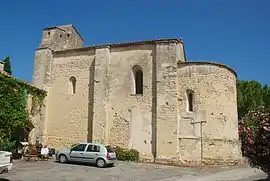 Church of St. Stephen | |
.svg.png.webp) Coat of arms | |
Location of Souvignargues 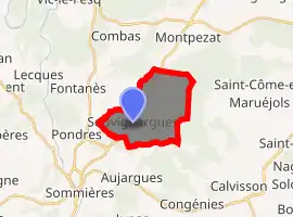
| |
 Souvignargues  Souvignargues | |
| Coordinates: 43°48′53″N 4°07′23″E | |
| Country | France |
| Region | Occitanie |
| Department | Gard |
| Arrondissement | Nîmes |
| Canton | Calvisson |
| Intercommunality | Pays de Sommières |
| Government | |
| • Mayor (2008–2014) | Serge Pattus |
| Area 1 | 11.09 km2 (4.28 sq mi) |
| Population (2017-01-01)[1] | 871 |
| • Density | 79/km2 (200/sq mi) |
| Time zone | UTC+01:00 (CET) |
| • Summer (DST) | UTC+02:00 (CEST) |
| INSEE/Postal code | 30324 /30250 |
| Elevation | 42–173 m (138–568 ft) (avg. 100 m or 330 ft) |
| 1 French Land Register data, which excludes lakes, ponds, glaciers > 1 km2 (0.386 sq mi or 247 acres) and river estuaries. | |
Population
| Year | Pop. | ±% |
|---|---|---|
| 1962 | 405 | — |
| 1968 | 406 | +0.2% |
| 1975 | 370 | −8.9% |
| 1982 | 460 | +24.3% |
| 1990 | 545 | +18.5% |
| 1999 | 589 | +8.1% |
| 2008 | 717 | +21.7% |
Sights
- Remains of the feudal castle (13th-14th centuries)
- Church of St. Stephen (Saint-Étienne d'Escattes), at Escattes, dating to the 12th century.
- Ruined Romanesque church of St. Andrew (12th century)
- Grotto of Bézal, inhabited from the mid-Palaeolithic Age
See also
References
- "Populations légales 2017". INSEE. Retrieved 6 January 2020.
| Wikimedia Commons has media related to Souvignargues. |
| Authority control |
|
|---|
This article is issued from Wikipedia. The text is licensed under Creative Commons - Attribution - Sharealike. Additional terms may apply for the media files.