Pujaut
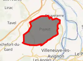
Pujaut is a commune in the Gard department in southern France. The village is situated on the south side of a small hill overlooking a flat plain that once formed the bed of a lake. The lake was drained at the beginning of the 17th century. The village is located 3.5 km west of the Rhône, 4.5 km north of Villeneuve-lès-Avignon and 5 km south of Roquemaure. In 2017 the commune had a population of 4,136.
Pujaut | |
|---|---|
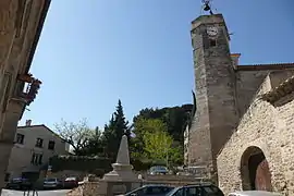
 The church of Pujaut | |
.svg.png.webp) Coat of arms | |
Location of Pujaut 
| |
 Pujaut  Pujaut | |
| Coordinates: 44°00′20″N 4°46′31″E | |
| Country | France |
| Region | Occitanie |
| Department | Gard |
| Arrondissement | Nîmes |
| Canton | Villeneuve-lès-Avignon |
| Intercommunality | CA Grand Avignon |
| Government | |
| • Mayor (2014–2020) | Guy David[1] |
| Area 1 | 23.5 km2 (9.1 sq mi) |
| Population (2017-01-01)[2] | 4,136 |
| • Density | 180/km2 (460/sq mi) |
| Time zone | UTC+01:00 (CET) |
| • Summer (DST) | UTC+02:00 (CEST) |
| INSEE/Postal code | 30209 /30131 |
| Elevation | 20–168 m (66–551 ft) (avg. 110 m or 360 ft) |
| 1 French Land Register data, which excludes lakes, ponds, glaciers > 1 km2 (0.386 sq mi or 247 acres) and river estuaries. | |
Population
|
|
See also
References
- "Résultats des élections municipales et communautaires 2014: GARD (30) - Pujaut" (in French). Ministère de l'Intérieur. Retrieved 25 November 2014.
- "Populations légales 2017". INSEE. Retrieved 6 January 2020.
Further reading
- Chardon, Michel (1975). "L'évolution morphologique des régions à l'Ouest du Rhône entre l'Ardoise et Aramon. Le réseau hydrographique et son évolution au Quaternaire. Versants et cuvettes de la dépression de Pujaut". Revue de géographie alpine (in French). 63 (3): 313–328. doi:10.3406/rga.1975.1424.
- Coulondres, Alfred (1877). "Notice sur la dessèchement des étangs de Rochefort et Pujaut". Mémoires & comptes-rendus de la Société scientifique et littéraire d'Alais (in French). 8 (Année 1876): 15–54.
- Jouffret, Marcel (1992). Pujaut, Mon Village. Nîmes, France: C. Lacour. ISBN 978-2-86971-646-9.
This article is issued from Wikipedia. The text is licensed under Creative Commons - Attribution - Sharealike. Additional terms may apply for the media files.