Stanton, California
Stanton is a city in western Orange County, California, part of the Los Angeles metropolitan area. The population was 38,186 at the 2010 census, up from 37,403 at the 2000 census. The city was incorporated in 1956 and operates under the Council-Manager form of government, providing a full range of municipal services. Stanton is bounded by Cypress on the west, Anaheim on the north, and east, and Garden Grove on the east and south.
Stanton, California | |
|---|---|
City | |
 Stanton City Hall | |
 Seal | |
| Motto(s): "Community Pride and Forward Vision"[1] | |
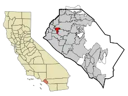 Location of Stanton within Orange County, California | |
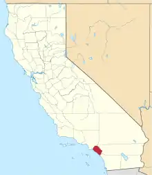
 Stanton, California Location in the United States | |
| Coordinates: 33°48′9″N 117°59′40″W | |
| Country | |
| State | |
| County | |
| Founded | 1911 |
| Incorporated | June 4, 1956[2] |
| Government | |
| • Type | Council–manager[3] |
| • City Council[4] | Mayor David Shawver Rigoberto Ramirez Carol Warren Gary Taylor Hong Alyce Van |
| Area | |
| • Total | 3.10 sq mi (8.03 km2) |
| • Land | 3.10 sq mi (8.03 km2) |
| • Water | 0.00 sq mi (0.00 km2) 0% |
| Elevation | 66 ft (20 m) |
| Population | |
| • Total | 37,827 |
| • Estimate (2019)[8] | 38,139 |
| • Density | 12,302.90/sq mi (4,750.04/km2) |
| Time zone | UTC-8 (PST) |
| • Summer (DST) | UTC-7 (PDT) |
| ZIP code | 90680 |
| Area code | 714 |
| FIPS code | 06-73962 |
| GNIS feature ID | 1661501[9] |
| Website | www |
History
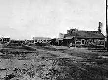
On November 4, 1905, the Los Angeles Interurban Railway[10] started service on the Santa Ana Line. It ran along an almost perfectly straight line between Watts and Santa Ana. Access to transportation allowed the population of the rural area to grow. This area is now Stanton and West Anaheim.
Stanton was named for Philip A. Stanton, a Republican assemblyman for Los Angeles from 1903 to 1909.[11]
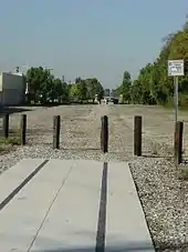
In 1908, the privately owned Pacific Electric Railway leased the Santa Ana Line and took over the service, extending its regional light-rail system. By 1928, the impressive thousand-mile system allowed the residents to conveniently travel throughout Los Angeles and Orange Counties. See 1928 Map. Passenger service to Santa Ana was discontinued in 1950, shortly after the railway was taken over by the Metropolitan Transportation Agency. Today, the easement still is owned by the Orange County Transportation Authority (OCTA). It crosses the intersections of Beach Boulevard/Pacific Street and Cerritos Avenue/Western Avenue.
The first City of Stanton was incorporated in 1911 and was then the largest city in Orange County by area.[12] The main motivation for incorporation was the City of Anaheim's plan to build a "sewage farm" to the west of their city. Former Speaker of the California State Assembly Phillip Ackley Stanton assisted in the incorporation and the city was named Stanton in his honor. In 1924, the residents voted to dis-incorporate to avoid the cost of building roads in the City.
In the early 1950s, the area had experienced a post-war population boom and the neighboring cities rapidly annexed land. In May 1956, the citizens responded by re-incorporating into today's City of Stanton.
Geography
Staton is directly bordered by Anaheim to the north and Cypress to the west. A southern salient of the city largely bisects the city of Garden Grove from its West Garden Grove neighborhood, making the city as a whole a neighbor of Stanton to the east, south, and west.[13]
According to the United States Census Bureau, the city has a total area of 3.15 square miles (8.2 km2), all land.
Demographics
| Historical population | |||
|---|---|---|---|
| Census | Pop. | %± | |
| 1920 | 695 | — | |
| 1960 | 11,163 | — | |
| 1970 | 18,186 | 62.9% | |
| 1980 | 23,723 | 30.4% | |
| 1990 | 30,491 | 28.5% | |
| 2000 | 37,403 | 22.7% | |
| 2010 | 37,827 | 1.1% | |
| 2019 (est.) | 38,139 | [8] | 0.8% |
| U.S. Decennial Census[14] | |||
2010
The 2010 United States Census[15] reported that Stanton had a population of 38,186. The population density was 12,122.5 people per square mile (4,680.6/km2). The racial makeup of Stanton was 16,991 (44.5%) White, 858 (2.2%) African American, 405 (1.1%) Native American, 8,831 (23.1%) Asian, 217 (0.6%) Pacific Islander, 9,274 (24.3%) from other races, and 1,610 (4.2%) from two or more races. Hispanic or Latino of any race were 19,417 persons (50.8%). Non-Hispanic Whites were 21.8% of the population.[16]
The Census reported that 37,836 people (99.1% of the population) lived in households, 92 (0.2%) lived in non-institutionalized group quarters, and 258 (0.7%) were institutionalized.
There were 10,825 households, out of which 5,015 (46.3%) had children under the age of 18 living in them, 5,551 (51.3%) were opposite-sex married couples living together, 1,798 (16.6%) had a female householder with no husband present, 860 (7.9%) had a male householder with no wife present. There were 645 (6.0%) unmarried opposite-sex partnerships, and 74 (0.7%) same-sex married couples or partnerships. 1,958 households (18.1%) were made up of individuals, and 846 (7.8%) had someone living alone who was 65 years of age or older. The average household size was 3.50. There were 8,209 families (75.8% of all households); the average family size was 3.90.
The population was spread out, with 10,566 people (27.7%) under the age of 18, 4,062 people (10.6%) aged 18 to 24, 11,289 people (29.6%) aged 25 to 44, 8,455 people (22.1%) aged 45 to 64, and 3,814 people (10.0%) who were 65 years of age or older. The median age was 33.0 years. For every 100 females, there were 98.0 males. For every 100 females age 18 and over, there were 95.8 males.
There were 11,283 housing units at an average density of 3,582.0 per square mile (1,383.0/km2), of which 5,418 (50.1%) were owner-occupied, and 5,407 (49.9%) were occupied by renters. The homeowner vacancy rate was 2.1%; the rental vacancy rate was 4.3%. 18,033 people (47.2% of the population) lived in owner-occupied housing units and 19,803 people (51.9%) lived in rental housing units.
According to the 2010 United States Census, Stanton had a median household income of $50,542, with 16.9% of the population living below the federal poverty line.[17]
2000
At the 2000 census,[18] there were 37,403 people, 10,767 households and 7,806 families residing in the city. The population density was 11,971.0 inhabitants per square mile (4,628.6/km2). There were 11,011 housing units at an average density of 3,524.1 per square mile (1,362.6/km2). The racial makeup of the city was 49.57% White, 2.27% African American, 1.06% Native American, 15.45% Asian, 0.92% Pacific Islander, 25.71% from other races, and 5.02% from two or more races. Hispanic or Latino of any race were 48.89% of the population.
There were 10,767 households, of which 41.8% had children under the age of 18 living with them, 50.2% were married couples living together, and 27.5% were non-families. 21.5% of all households were made up of individuals, and 9.3% had someone living alone who was 65 years of age or older. The average household size was 3.43 and the average family size was 3.93.
Age distribution was 30.4% under the age of 18, 10.5% from 18 to 24, 33.3% from 25 to 44, 16.2% from 45 to 64, and 9.6% who were 65 years of age or older. The median age was 30 years. For every 100 females, there were 102.4 males. For every 100 females age 18 and over, there were 99.1 males.
The median household income was $39,127, and the median family income was $40,162. Males had a median income of $27,644 versus $25,995 for females. The per capita income for the city was $14,197. About 13.4% of families and 18.0% of the population were below the poverty line, including 22.2% of those under age 18 and 13.2% of those age 65 or over.
Economy
According to the City's 2018 Comprehensive Annual Financial Report,[19] the top employers in the city are:
| # | Employer | # of employees |
|---|---|---|
| 1 | Rowntree Gardens | 340 |
| 2 | The Home Depot | 154 |
| 3 | All Metals Processing | 150 |
| 4 | USS Cal Builders | 144 |
| 5 | Super King Market | 140 |
| 6 | CR&R | 122 |
| 7 | Adventure City | 105 |
| 8 | Great ScottTree Service | 97 |
| 9 | Custom Pipe & Coupling | 89 |
| 10 | Wal-Mart Neighborhood Market | 97 |
Parks and recreation
Public parks include Harry M. Dotson Park, Hollenbeck Park, the Norm Ross Sports Complex, Martha Weishaupt Linear Park, Premier Park, Stanton Community Services Center Park, Stanton Municipal Tennis Center, Stanton Park, Stanton Central Park,[20] Veterans Memorial Park and Zuniga Park.[21][22] Adventure City, a small amusement park, is located in Stanton.
In the 1950s, with help of the James Irvine Foundation,[23] the Stanton Lions Club[24] and a land donation from a local farmer, Lions-Stock Park was built with a sports facility and community center.[25] This privately owned park was later purchased by the school board.
Government and politics
| Year | Democratic | Republican | Third Parties |
|---|---|---|---|
| 2020[26] | 56.24% 7,557 | 41.86% 5,625 | 1.90% 255 |
| 2016[27] | 62.85% 6,286 | 30.95% 3,095 | 6.20% 620 |
| 2012[28] | 59.80% 5,057 | 37.83% 3,199 | 2.38% 201 |
| 2008[29] | 53.77% 4,842 | 43.98% 3,960 | 2.25% 203 |
| 2004[30] | 43.49% 3,588 | 55.16% 4,551 | 1.35% 111 |
| 2000[31] | 51.41% 3,752 | 44.85% 3,273 | 3.74% 273 |
| 1996[32] | 48.52% 3,206 | 38.82% 2,565 | 12.67% 837 |
| 1992[33] | 39.76% 3,263 | 36.30% 2,979 | 23.93% 1,964 |
| 1988[34] | 39.15% 3,251 | 59.65% 4,954 | 1.20% 100 |
| 1984[35] | 30.92% 2,581 | 68.16% 5,689 | 0.92% 77 |
| 1980[36] | 29.35%% 2,151 | 61.74% 4,525 | 8.91% 653 |
State and federal representation
In the California State Legislature, Stanton is in the 29th Senate District, represented by Democrat Josh Newman, and in the 65th Assembly District, represented by Democrat Sharon Quirk-Silva.[39]
In the United States House of Representatives, Stanton is in California's 47th congressional district, represented by Democrat Alan Lowenthal.[40]
Education
Residents of the City are served by four public school districts and one private school:
The Garden Grove Unified School District operates a special education school in Stanton, named Carver (ECEC).
The Savanna School District serves elementary school students and has a high API similar school ranking of 9.75 out of 10 as compiled by the California Department of Education.[41]
The Magnolia School District's Baden-Powell and Pyles Schools have been named as a Title I Academic Achievement School.[42]
Anaheim Union High School District.
Saint Polycarp School (K-8) Catholic School
Educational resources
The Orange County Public Library has a branch Library in Stanton. In addition to over 60,000 volumes, it offers morning and an evening story time, afternoon craft programs, free high speed wireless Internet access (WiFi), and Internet instruction; and the Stanton Boys and Girls Club, located next door, offers computer access, tutoring and a homework help room for elementary school children. Two additional organizations also help educate children and prepare them for careers. The Orange County Children's Theater produces plays and musicals. Often Broadway style musicals are held in the City's Community Center with a professional sound system, lighting and staging. The Future Scientists and Engineers of America organization offers hands-on projects that encourage middle and high school aged children to learn about mathematics, science and engineering.
Infrastructure
Freeways
Stanton is located north of the Garden Grove (22) Freeway, south of the Artesia (91) Freeway, east of the San Gabriel River (605) Freeway and west of the Santa Ana (5) Freeway.
Streets
East–west major thoroughfares are (in order from north to south) Cerritos Avenue, Katella Avenue, Orangewood Avenue, Chapman Avenue, Lampson Avenue and at the southernmost boundary, Garden Grove Boulevard. North–south thoroughfares are (in order from west to east) Knott Avenue, Western Avenue, Beach Boulevard, Dale Avenue and Magnolia Avenue.[43]
Emergency services
The City of Stanton contracts its protective services as common with many cities in Orange County. Police services are provided by Orange County Sheriff's Department (OCSD) who has a Northwest County Sheriff's department located in Stanton. Fire protection is provided by the Orange County Fire Authority(OCSD). Ambulance service is contracted through the County with Care Ambulance Service. The city is a safe place to do business or live in as it has a crime rate that is about the same as the rest of Orange County, and significantly less than the rest of California.[44] As of May 2008, the residents are working with the Department to reduce quality-of-life crimes, such as graffiti and illegal dumping.[45]
The city's crime rate has decreased 40% from 2007 to 2013.[46]
Community service organizations
- American Legion Post 783
- Greater Anaheim Chamber of Commerce
- Stanton Boys and Girls Club
- Stanton Kiwanis Club
- Stanton Lions Club
See also
 Greater Los Angeles portal
References
- "City of Stanton, California Website". City of Stanton, California Website. Retrieved May 26, 2018.
- "California Cities by Incorporation Date". California Association of Local Agency Formation Commissions. Archived from the original (Word) on October 17, 2013. Retrieved August 25, 2014.
- "City of Stanton > Council and Commissions > City Council". City of Stanton. Retrieved December 18, 2019.
- "City Council". Stanton, CA. Retrieved November 29, 2018.
- "2019 U.S. Gazetteer Files". United States Census Bureau. Retrieved July 1, 2020.
- "Stanton". Geographic Names Information System. United States Geological Survey. Retrieved April 15, 2015.
- "Stanton (city) QuickFacts". United States Census Bureau. Archived from the original on April 17, 2015. Retrieved May 25, 2019.
- "Population and Housing Unit Estimates". United States Census Bureau. May 24, 2020. Retrieved May 27, 2020.
- U.S. Geological Survey Geographic Names Information System: Stanton
- see http://www.erha.org/pessa.htm
- Capace, Nancy (1999). Encyclopedia of California. North American Book Dist LLC. Page 443. ISBN 9780403093182.
- See https://www.ocregister.com/2010/05/20/stanton-the-city-that-was-born-twice/
- "City Boundaries". Orange County GIS. Retrieved January 23, 2021.
- "Census of Population and Housing". Census.gov. Retrieved May 25, 2019.
- "2010 Census Interactive Population Search: CA - Stanton city". U.S. Census Bureau. Archived from the original on July 15, 2014. Retrieved July 12, 2014.
- "Stanton (city), California". State & County QuickFacts. U.S. Census Bureau. Archived from the original on April 17, 2015. Retrieved July 15, 2012.
- "Archived copy". Archived from the original on April 17, 2015. Retrieved July 15, 2012.CS1 maint: archived copy as title (link)
- "U.S. Census website". United States Census Bureau. Retrieved January 31, 2008.
- City of Stanton Comprehensive Annual Financial Report
- http://www.ocregister.com/articles/park-720616-stanton-open.html
- Stanton parks
- See Lions press release November 8
- James Irvine Foundation
- Stanton Lions Club
- See Lions Press Release from 1958, page 1 and page 2
- "Votes cast" (PDF). www.ocvote.com. Retrieved January 18, 2021.
- https://www.ocvote.com/fileadmin/live/gen2016/sov.pdf
- https://www.ocvote.com/fileadmin/live/gen2012/sov-for-web.pdf
- https://www.ocvote.com/fileadmin/user_upload/sov/gen2008/sov.pdf
- https://www.ocvote.com/fileadmin/user_upload/sov/e13/sov1.pdf
- https://www.ocvote.com/fileadmin/user_upload/sov/gen2000/gen2000-SOV.pdf
- California. Secretary of State (March 30, 1968). "Statement of vote". Sacramento, Calif. : The Secretary – via Internet Archive.
- California. Secretary of State (March 30, 1968). "Statement of vote". Sacramento, Calif. : The Secretary – via Internet Archive.
- Statement of the Vote. Sacramento, Calif. : The Secretary. 1968.
- Statement of the Vote. Sacramento, Calif. : The Secretary. 1968.
- Statement of the Vote. Sacramento, Calif. : The Secretary. 1968.
- "City Council". City of Stanton. Retrieved July 5, 2018.
- "City Manager". City of Stanton. Retrieved May 26, 2019.
- "Statewide Database". UC Regents. Archived from the original on February 1, 2015. Retrieved December 1, 2014.
- "California's 47th Congressional District - Representatives & District Map". Civic Impulse, LLC.
- See Savanna School District website
- See Magnolia School District website
- Google Maps: Stanton, CA
- See crime statistics on OCSD website
- Press release from Lions website
- http://ocsmallbusiness.com/crime-decreases-dramatically-in-some-orange-county-cities-stanton-west-anaheim-area/ OC NEWS ARTICLE Stanton reports a drop in crime from 2012
External links
| Wikimedia Commons has media related to Stanton, California. |
| Wikivoyage has a travel guide for Stanton. |
Municipalities and communities of Orange County, California, United States | ||
|---|---|---|
| Cities |
|  Orange County map |
| CDPs | ||
| Unincorporated communities | ||
| Ghost towns | ||
| ||

| Authority control |
|---|