Taghit
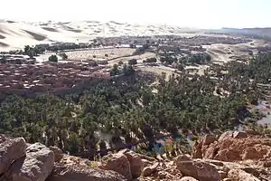
Taghit (Arabic: ﺗﺎﻏﻴﺖ) is a town and commune in Taghit District, Béchar Province, in western Algeria. The town is an oasis watered by the underground Oued Zousfana, which runs along beside the dunes of the Grand Erg Occidental.[3] According to the 2008 census its population is 6,317,[2] up from 6,047 in 1998,[4] with an annual growth rate of 0.4%.[2] The commune covers an area of 8,080 square kilometres (3,120 sq mi).[1]
Taghit
ﺗﺎﻏﻴﺖ | |
|---|---|
Commune and town | |
 | |
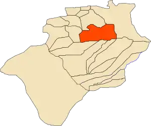 Location of Taghit commune within Béchar Province | |
 Taghit Location of Taghit within Algeria | |
| Coordinates: 30°55′N 2°2′W | |
| Country | |
| Province | Béchar Province |
| District | Taghit District (coextensive) |
| Area | |
| • Total | 8,080 km2 (3,120 sq mi) |
| Elevation | 623 m (2,044 ft) |
| Population (2008)[2] | |
| • Total | 6,317 |
| • Density | 0.78/km2 (2.0/sq mi) |
| Time zone | UTC+1 (CET) |
History
The town was the site of the Battle of Taghit in 1903, in which 4000 Zayanes Berbers besieged the French in the town, whom they outnumbered by 10 to 1. The attackers were later forced to retreat.[5]
Geography
Taghit lies on the left (eastern) bank of the Oued Zouzfana. The Grand Erg Occidental, a large area of continuous sand dunes, lies to the east, while the rocky Djebel Baroun lies to the west across the river.
Climate
Taghit has a hot desert climate (Köppen climate classification BWh), with extremely hot summers and cool winters, and very little precipitation throughout the year.
| Climate data for Taghit | |||||||||||||
|---|---|---|---|---|---|---|---|---|---|---|---|---|---|
| Month | Jan | Feb | Mar | Apr | May | Jun | Jul | Aug | Sep | Oct | Nov | Dec | Year |
| Average high °C (°F) | 17.0 (62.6) |
20.4 (68.7) |
24.0 (75.2) |
28.6 (83.5) |
33.0 (91.4) |
38.1 (100.6) |
42.3 (108.1) |
40.8 (105.4) |
35.8 (96.4) |
28.7 (83.7) |
22.0 (71.6) |
17.9 (64.2) |
29.1 (84.3) |
| Daily mean °C (°F) | 9.9 (49.8) |
12.9 (55.2) |
16.7 (62.1) |
21.0 (69.8) |
25.4 (77.7) |
30.5 (86.9) |
34.5 (94.1) |
33.3 (91.9) |
28.7 (83.7) |
21.9 (71.4) |
15.5 (59.9) |
11.0 (51.8) |
21.8 (71.2) |
| Average low °C (°F) | 2.8 (37.0) |
5.4 (41.7) |
9.4 (48.9) |
13.5 (56.3) |
17.9 (64.2) |
23.0 (73.4) |
26.7 (80.1) |
25.9 (78.6) |
21.6 (70.9) |
15.1 (59.2) |
9.0 (48.2) |
4.1 (39.4) |
14.5 (58.2) |
| Average precipitation mm (inches) | 11 (0.4) |
8 (0.3) |
11 (0.4) |
7 (0.3) |
4 (0.2) |
3 (0.1) |
1 (0.0) |
3 (0.1) |
6 (0.2) |
11 (0.4) |
12 (0.5) |
11 (0.4) |
88 (3.3) |
| Source: climate-data.org[6] | |||||||||||||
Economy
Agriculture is an important industry in Taghit. The commune has a total of 2,280 hectares (5,600 acres) of arable land, of which 1,432 hectares (3,540 acres) is irrigated.[7] There are a total of 137,450 date palms planted in the commune.[8] As of 2009 there were 3,330 sheep, 2,995 goats, 2,481 camels, and 62 cattle. There were also 24,000 chickens in 2 buildings.[9]
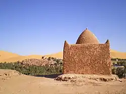
Tourism is also significant in Taghit due to many Neolithic rock engravings in the area. Other attractions include sand dunes, palm groves, the old ksar and the zawiya.[10] There is one hotel in Taghit, the three-star Taghit.[11]
Infrastructure and housing
90% of Taghits's population are connected to drinking water,[12] 96% are connected to the sewerage system,[13] and 93% (including 1,485 buildings) have access to electricity.[14] There is one fuel service station in the town.[15]
Taghit has a total of 1,551 houses, of which 913 are occupied, giving an occupation rate of 6.9 inhabitants per occupied building.[16]
Transportation
There are three main roads out of Taghit: one leads northwest to the N6 highway (Bechar-Adrar section) just south of Bechar, another leads southwest through Igli to the N6 further south, and the third leads northeast, also to the N6 (Bechar-Mecheria section) northeast of Bechar, near Figuig. A number of small localities lie along the Oued Zouzfana to the south; these are connected by a local road.
Taghit is 95 kilometres (59 mi) from the provincial capital, Béchar.[17]
There is a total length of 146 kilometres (91 mi) of roads in the commune.[18]
Education
There are 5 elementary schools, with 39 classrooms including 30 in use.[19] There are a total of 1,310 school students.[20]
5.9% of the population has a tertiary education, and another 18.4% has competed secondary education.[21] The overall literacy rate is 81.4%, and is 86.6% among males and 76.7% among females.[22]
Health
Taghit has 4 room care facilities, and a private pharmacy, and a medical operating theatre. The nearest hospital (by road) is in Béchar.[23]
Localities
The commune is composed of five localities:[25]
- Taghit
- Zaouia Fougania
- Berrabi Bakhti
- Zaouia Tahtania
- Brika
References
- "Population, Area and Density per Commune" (in French). Official Website of the Wilaya of Bechar. Archived from the original on 22 February 2014. Retrieved 16 March 2013.
- "Population: Béchar Wilaya" (PDF) (in French). Office National des Statistiques Algérie. Retrieved 13 February 2013.
- N. Huguenin-Gonon (1973). Algeria. Nagel Publishers. ISBN 978-2-8263-0604-7.
- "Algeria Communes". Statoids. Retrieved 9 March 2013.
- "History of the Battle of El Moungar" (in French). French Ministry of Defence. Retrieved 15 March 2013.
- "Climate data for: Taghit". climate-data.org. Retrieved 15 March 2013.
- "Distribution of Agricultural Land" (in French). Official Website of the Wilaya of Bechar. Archived from the original on 10 July 2014. Retrieved 9 March 2013.
- "Plant Productions" (in French). Official Website of the Wilaya of Bechar. Archived from the original on 20 August 2014. Retrieved 9 March 2013.
- "Animal Production" (in French). Official Website of the Wilaya of Bechar. Archived from the original on 20 August 2014. Retrieved 9 March 2013.
- "Tourism Sites and Monuments" (in French). Official Website of the Wilaya of Bechar. Retrieved 9 March 2013.
- "Census of Hotels" (in French). Official Website of the Wilaya of Bechar. Retrieved 9 March 2013.
- "Drinking Water" (in French). Official Website of the Wilaya of Bechar. Archived from the original on 9 July 2014. Retrieved 9 March 2013.
- "Sewerage Networks" (in French). Official Website of the Wilaya of Bechar. Archived from the original on 10 July 2014. Retrieved 9 March 2013.
- "Electrification" (in French). Official Website of the Wilaya of Bechar. Archived from the original on 9 July 2014. Retrieved 9 March 2013.
- "Fuel Distribution" (in French). Official Website of the Wilaya of Bechar. Archived from the original on 10 July 2014. Retrieved 9 March 2013.
- "Housing" (in French). Official Website of the Wilaya of Bechar. Archived from the original on 4 March 2016. Retrieved 9 March 2013.
- "Presentation" (in French). Site Officiel de la Wilaya de Béchar. Archived from the original on 16 February 2013. Retrieved 19 February 2013.
- "Density Kilometres" (in French). Official Website of the Wilaya of Bechar. Archived from the original on 29 April 2014. Retrieved 9 March 2013.
- "School Infrastructure" (in French). Official Website of the Wilaya of Bechar. Archived from the original on 29 April 2014. Retrieved 9 March 2013.
- "Number of Pupils" (in French). Official Website of the Wilaya of Bechar. Archived from the original on 4 March 2016. Retrieved 9 March 2013.
- "Structure relative de la population résidente des ménages ordinaires et collectifs âgée de 6 ans et plus selon le niveau d'instruction et la commune de résidence" (PDF) (in French). Office National des Statistiques Algérie. Retrieved 13 February 2013.
- "Taux d'analphabétisme et taux d'alphabétisation de la population âgée de 15 ans et plus, selon le sexe et la commune de résidence " (PDF) (in French). Office National des Statistiques Algérie. Retrieved 13 February 2013.
- "Health Facilities by Commune" (in French). Official Website of the Wilaya of Bechar. Archived from the original on 29 April 2014. Retrieved 9 March 2013.
- "Mosques and Koranic Rooms" (in French). Official Website of the Wilaya of Bechar. Archived from the original on 4 March 2016. Retrieved 9 March 2013.
- "Décret n° 84-365, fixant la composition, la consistance et les limites territoriale des communes. Wilaya d'El Oued" (PDF) (in French). Journal officiel de la République Algérienne. 19 December 1984. p. 1489. Archived from the original (PDF) on 2 March 2013 or before. Retrieved 2 March 2013. Check date values in:
|archivedate=(help)
External links
| Wikimedia Commons has media related to Taghit. |
Places adjacent to Taghit | |
|---|---|
Capital: Béchar | ||
| Béchar District | .svg.png.webp) | |
| Abadla District | ||
| Béni Abbès District | ||
| Béni Ounif District | ||
| El Ouata District | ||
| Igli District | ||
| Kénadsa District | ||
| Kerzaz District | ||
| Lahmar District | ||
| Ouled Khodeïr District | ||
| Tabelbala District | ||
| Taghit District | ||
