Igli, Algeria
Igli (Arabic: اﻳﻘﻠﻰ) is a town and commune in Béchar Province, western Algeria, located 152 km south of Bechar. It is coextensive with Igli District. Its population was 6,682 as of the 2008 census,[2] up from 5,474 in 1998,[3] and an annual population growth rate of 2.1%.[2] The commune covers an area of 6,220 square kilometres (2,400 sq mi).[1]
Igli
اﻳﻘﻠﻰ | |
|---|---|
Commune and town | |
 | |
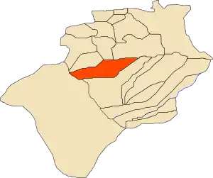 Location of Igli commune within Béchar Province | |
 Igli Location of Igli within Algeria | |
| Coordinates: 30°27′0″N 2°18′33″W | |
| Country | |
| Province | Béchar Province |
| District | Igli District |
| Area | |
| • Total | 6,220 km2 (2,400 sq mi) |
| Elevation | 507 m (1,663 ft) |
| Population (2008)[2] | |
| • Total | 6,682 |
| • Density | 1.1/km2 (2.8/sq mi) |
| Time zone | UTC+1 (CET) |
Its inhabitants, along with those of the small neighbouring town of Mazzer, speak a Zenati Berber language termed tabəldit, closely related to that of other south-western Algerian ksars and of Figuig.[4]
Geography
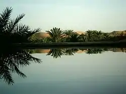
Igli lies on the left (eastern) bank of the Oued Saoura in the Saoura valley, just south of the confluence of Oued Guir and Oued Zouzfana. The Grand Erg Occidental, a large area of continuous sand dunes lies to the east, while the Hamada, a broad rocky plateau, lies across the river to the west.
Climate
Igli has a hot desert climate, with extremely hot summers and mild winters, and very little precipitation throughout the year.
| Climate data for Igli | |||||||||||||
|---|---|---|---|---|---|---|---|---|---|---|---|---|---|
| Month | Jan | Feb | Mar | Apr | May | Jun | Jul | Aug | Sep | Oct | Nov | Dec | Year |
| Average high °C (°F) | 18.2 (64.8) |
21.5 (70.7) |
25.3 (77.5) |
29.9 (85.8) |
34.5 (94.1) |
39.7 (103.5) |
43.7 (110.7) |
42.0 (107.6) |
37.1 (98.8) |
30.1 (86.2) |
23.2 (73.8) |
18.7 (65.7) |
30.3 (86.6) |
| Daily mean °C (°F) | 10.6 (51.1) |
13.8 (56.8) |
17.7 (63.9) |
22.1 (71.8) |
26.6 (79.9) |
31.7 (89.1) |
35.6 (96.1) |
34.2 (93.6) |
29.8 (85.6) |
23.0 (73.4) |
16.6 (61.9) |
11.8 (53.2) |
22.8 (73.0) |
| Average low °C (°F) | 3.5 (38.3) |
6.2 (43.2) |
10.2 (50.4) |
14.3 (57.7) |
18.8 (65.8) |
23.8 (74.8) |
27.5 (81.5) |
26.5 (79.7) |
22.5 (72.5) |
15.9 (60.6) |
10.0 (50.0) |
5.0 (41.0) |
15.4 (59.6) |
| Average precipitation mm (inches) | 12 (0.5) |
8 (0.3) |
12 (0.5) |
7 (0.3) |
4 (0.2) |
2 (0.1) |
1 (0.0) |
2 (0.1) |
5 (0.2) |
9 (0.4) |
11 (0.4) |
11 (0.4) |
84 (3.4) |
| Source: climate-data.org[5] | |||||||||||||
Economy
Agriculture is an important industry in Igli. The commune has a total of 1,130 hectares (2,800 acres) of arable land, of which 1,002 hectares (2,480 acres) is irrigated.[6] There are a total of 75,450 date palms planted in the commune.[7] As of 2009 there were 4,652 sheep, 1,785 goats, 401 camels, and 5 cattle.
Local tourist attractions include palm groves, the old ksar, and local caves.
Infrastructure and housing
90% of Igli's population is connected to drinking water,[8] 95% is connected to the sewerage system,[9] and 99% (including 1,728 buildings) have access to electricity.[10] There is one fuel service station in the town.[11]
Igli has a total of 1,425 houses, of which 972 are occupied, giving an occupation rate of 6.9 inhabitants per occupied building.[12]
Transportation
Igli is connected by a local road to the N6 national highway between Béchar to the north and Adrar to the southeast. Abadla is accessible to the north via the N6, while to the south the towns of El Ouata, Béni Abbès and Kerzaz, among others can be accessed. Igli is 153 kilometres (95 mi) from the provincial capital, Béchar.[13]
There is a total length of 147 kilometres (91 mi) of roads in the commune.[14]
Education
There are 4 elementary schools, with 36 classrooms including 23 in use.[15] There are a total of 1,282 school students.[16]
9.8% of the population has a tertiary education (the highest in the province), and another 19.8% has competed secondary education.[17] The overall literacy rate is 84.3%, and is 88.3% among males and 79.9% among females.[18]
Health
Igli has one polyclinic, 3 room care facilities, and a maternity ward.[19]
Localities
The commune is composed of three localities:[21]
- Igli
- Touzdit
- Mazzer
The locality of Mazzer is located about 15 kilometres (9.3 mi) south of Igli on the eastern bank of the Oued Saoura.[22]
References
- "Population, Area and Density per Commune" (in French). Official Website of the Wilaya of Bechar. Archived from the original on 22 February 2014. Retrieved 16 March 2013.
- "Population: Béchar Wilaya" (PDF) (in French). Office National des Statistiques Algérie. Archived from the original (PDF) on 16 May 2013. Retrieved 13 February 2013.
- "Algeria Communes". Statoids. Retrieved 9 March 2013.
- Maarten Kossmann, "Grammatical notes on the Berber dialect of Igli (Sud oranais, Algeria)", in ed. D. Ibriszimow, M. Kossmann, H. Stroomer, R. Vossen, Études berbères V – Essais sur des variations dialectales et autres articles. Köln: Rüdiger Köppe, 2010.
- "Climate data for: Igli". climate-data.org. Retrieved 10 March 2013.
- "Distribution of Agricultural Land" (in French). Official Website of the Wilaya of Bechar. Archived from the original on 10 July 2014. Retrieved 9 March 2013.
- "Plant Productions" (in French). Official Website of the Wilaya of Bechar. Archived from the original on 20 August 2014. Retrieved 9 March 2013.
- "Drinking Water" (in French). Official Website of the Wilaya of Bechar. Archived from the original on 9 July 2014. Retrieved 9 March 2013.
- "Sewerage Networks" (in French). Official Website of the Wilaya of Bechar. Archived from the original on 10 July 2014. Retrieved 9 March 2013.
- "Electrification" (in French). Official Website of the Wilaya of Bechar. Archived from the original on 9 July 2014. Retrieved 9 March 2013.
- "Fuel Distribution" (in French). Official Website of the Wilaya of Bechar. Archived from the original on 10 July 2014. Retrieved 9 March 2013.
- "Housing" (in French). Official Website of the Wilaya of Bechar. Archived from the original on 4 March 2016. Retrieved 9 March 2013.
- "Presentation" (in French). Site Officiel de la Wilaya de Béchar. Archived from the original on 16 February 2013. Retrieved 19 February 2013.
- "Density Kilometres" (in French). Official Website of the Wilaya of Bechar. Archived from the original on 29 April 2014. Retrieved 9 March 2013.
- "School Infrastructure" (in French). Official Website of the Wilaya of Bechar. Archived from the original on 29 April 2014. Retrieved 9 March 2013.
- "Number of Pupils" (in French). Official Website of the Wilaya of Bechar. Archived from the original on 4 March 2016. Retrieved 9 March 2013.
- "Structure relative de la population résidente des ménages ordinaires et collectifs âgée de 6 ans et plus selon le niveau d'instruction et la commune de résidence" (PDF) (in French). Office National des Statistiques Algérie. Archived from the original (PDF) on 17 May 2013. Retrieved 13 February 2013.
- "Taux d'analphabétisme et taux d'alphabétisation de la population âgée de 15 ans et plus, selon le sexe et la commune de résidence " (PDF) (in French). Office National des Statistiques Algérie. Archived from the original (PDF) on 16 May 2013. Retrieved 13 February 2013.
- "Health Facilities by Commune" (in French). Official Website of the Wilaya of Bechar. Archived from the original on 29 April 2014. Retrieved 9 March 2013.
- "Mosques and Koranic Rooms" (in French). Official Website of the Wilaya of Bechar. Archived from the original on 4 March 2016. Retrieved 9 March 2013.
- "Décret n° 84-365, fixant la composition, la consistance et les limites territoriale des communes. Wilaya d'El Oued" (PDF) (in French). Journal officiel de la République Algérienne. 19 December 1984. p. 1490. Archived from the original (PDF) on 6 January 2015. Retrieved 2 March 2013.
- "Mazzer, Algeria". Google Maps. Retrieved 10 March 2013.
Places adjacent to Igli, Algeria | |
|---|---|
Capital: Béchar | ||
| Béchar District | .svg.png.webp) | |
| Abadla District | ||
| Béni Abbès District | ||
| Béni Ounif District | ||
| El Ouata District | ||
| Igli District | ||
| Kénadsa District | ||
| Kerzaz District | ||
| Lahmar District | ||
| Ouled Khodeïr District | ||
| Tabelbala District | ||
| Taghit District | ||
