Talipao
Talipao, officially the Municipality of Talipao (Tausūg: Dāira sin Talipao; Tagalog: Bayan ng Talipao), is a 1st class municipality in the province of Sulu, Philippines. According to the 2015 census, it has a population of 80,255 people. [3]
Talipao | |
|---|---|
| Municipality of Talipao | |
 The Hadja Sitti Raya Mosque | |
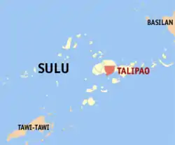 Map of Sulu with Talipao highlighted | |
OpenStreetMap 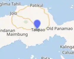
| |
.svg.png.webp) Talipao Location within the Philippines | |
| Coordinates: 5°58′34″N 121°06′31″E | |
| Country | |
| Region | Bangsamoro Autonomous Region in Muslim Mindanao (BARMM) |
| Province | Sulu |
| District | 1st District |
| Barangays | 52 (see Barangays) |
| Government | |
| • Type | Sangguniang Bayan |
| • Mayor | Nivocadnezar I. Tulawie |
| • Vice Mayor | Zulficar T. Tulawie |
| • Representative | Samier A. Tan |
| • Electorate | 26,088 voters (2019) |
| Area | |
| • Total | 380.57 km2 (146.94 sq mi) |
| Elevation | 157 m (515 ft) |
| Highest elevation | 506 m (1,660 ft) |
| Lowest elevation | 0 m (0 ft) |
| Population | |
| • Total | 80,255 |
| • Density | 210/km2 (550/sq mi) |
| • Households | 12,190 |
| Economy | |
| • Income class | 1st municipal income class |
| • Poverty incidence | 58.05% (2015)[4] |
| • Revenue | ₱158,397,277.21 (2016) |
| Service provider | |
| • Electricity | Sulu Electric Cooperative |
| Time zone | UTC+8 (PST) |
| ZIP code | 7403 |
| PSGC | |
| IDD : area code | +63 (0)68 |
| Climate type | tropical climate |
| Native languages | Tausug Tagalog |
| Website | www |
Etymology
The municipality of Talipao derived its name from a certain couple, “Tal” and “Pao”, that of the husband’s and wife’s name respectively.
History
From the district of Jolo, it was transformed into a full-pledged municipality on July 1, 1957, under the provision of the Department of Mindanao and Sulu Administrative Code.
Geography
The Municipality of Talipao’s total area coverage is approximately 38,057.00 hectares. This constitute more or less 20.63% of Sulu’s total land area. It is bounded on the north by the municipality of Patikul; on the south by Sulu Sea; on the east by the municipality of Panglima Estino; and by the municipality of Maimbung on its west side.
The municipality of Talipao lies right in the mid portion of Jolo island with its Barangay Poblacion basically situated in the innermost central part of the municipality. From the capital town of Jolo, Talipao is connected with concrete-type national road which is approximately 22.8 kilometres (14.2 mi) away from the Sulu Provincial Capitol Complex.
Barangays
Talipao is politically subdivided into 52 barangays.
- Andalan
- Bagsak
- Bandang
- Bilaan (Poblacion)
- Bud Bunga
- Buntod
- Buroh
- Dalih
- Gata
- Kabatuhan Bilaan
- Kabatuhan Tiis
- Kabungkol
- Kagay
- Kahawa
- Kandaga
- Kanlibot
- Kiutaan
- Kuhaw
- Kulamboh
- Kuttong
- Lagtoh
- Lambanah
- Liban
- Liu-Bud Pantao
- Lower Binuang
- Lower Kamuntayan
- Lower Laus
- Lower Sinumaan
- Lower Talipao
- Lumbayao
- Lumping Pigih Daho
- Lungkiaban
- Mabahay
- Mahala
- Mampallam
- Marsada
- Mauboh
- Mungit-mungit
- Niog-Sangahan
- Pantao
- Samak
- Talipao Proper
- Tampakan
- Tiis
- Tinggah
- Tubod
- Tuyang
- Upper Binuang
- Upper Kamuntayan
- Upper Laus
- Upper Sinumaan
- Upper Talipao
Climate
| Climate data for Talipao, Sulu | |||||||||||||
|---|---|---|---|---|---|---|---|---|---|---|---|---|---|
| Month | Jan | Feb | Mar | Apr | May | Jun | Jul | Aug | Sep | Oct | Nov | Dec | Year |
| Average high °C (°F) | 27 (81) |
27 (81) |
27 (81) |
28 (82) |
28 (82) |
28 (82) |
28 (82) |
28 (82) |
28 (82) |
28 (82) |
28 (82) |
27 (81) |
28 (82) |
| Average low °C (°F) | 26 (79) |
26 (79) |
26 (79) |
27 (81) |
27 (81) |
27 (81) |
27 (81) |
27 (81) |
27 (81) |
27 (81) |
27 (81) |
27 (81) |
27 (81) |
| Average precipitation mm (inches) | 170 (6.7) |
130 (5.1) |
125 (4.9) |
122 (4.8) |
229 (9.0) |
286 (11.3) |
254 (10.0) |
248 (9.8) |
182 (7.2) |
257 (10.1) |
233 (9.2) |
188 (7.4) |
2,424 (95.5) |
| Average rainy days | 18.3 | 15.3 | 15.2 | 14.6 | 22.8 | 24.0 | 24.3 | 23.3 | 20.5 | 22.6 | 21.9 | 19.3 | 242.1 |
| Source: Meteoblue[5] | |||||||||||||
Demographics
|
| |||||||||||||||||||||||||||||||||||||||||||||
| Source: Philippine Statistics Authority [3] [6] [7][8] | ||||||||||||||||||||||||||||||||||||||||||||||
References
- Municipality of Talipao | (DILG)
- "Province: Sulu". PSGC Interactive. Quezon City, Philippines: Philippine Statistics Authority. Retrieved 12 November 2016.
- Census of Population (2015). "ARMM – Autonomous Region in Muslim Mindanao". Total Population by Province, City, Municipality and Barangay. PSA. Retrieved 20 June 2016.
- https://psa.gov.ph/sites/default/files/City%20and%20Municipal-level%20Small%20Area%20Poverty%20Estimates_%202009%2C%202012%20and%202015_0.xlsx; publication date: 10 July 2019; publisher: Philippine Statistics Authority.
- "Talipao, Sulu : Average Temperatures and Rainfall". Meteoblue. Retrieved 31 January 2019.
- Census of Population and Housing (2010). "ARMM – Autonomous Region in Muslim Mindanao". Total Population by Province, City, Municipality and Barangay. NSO. Retrieved 29 June 2016.
- Censuses of Population (1903–2007). "ARMM – Autonomous Region in Muslim Mindanao". Table 1. Population Enumerated in Various Censuses by Province/Highly Urbanized City: 1903 to 2007. NSO.
- "Province of Sulu". Municipality Population Data. Local Water Utilities Administration Research Division. Retrieved 17 December 2016.
- "Poverty incidence (PI):". Philippine Statistics Authority. Retrieved 28 December 2020.
- https://psa.gov.ph/sites/default/files/NSCB_LocalPovertyPhilippines_0.pdf; publication date: 29 November 2005; publisher: Philippine Statistics Authority.
- https://psa.gov.ph/sites/default/files/2003%20SAE%20of%20poverty%20%28Full%20Report%29_1.pdf; publication date: 23 March 2009; publisher: Philippine Statistics Authority.
- https://psa.gov.ph/sites/default/files/2006%20and%202009%20City%20and%20Municipal%20Level%20Poverty%20Estimates_0_1.pdf; publication date: 3 August 2012; publisher: Philippine Statistics Authority.
- https://psa.gov.ph/sites/default/files/2012%20Municipal%20and%20City%20Level%20Poverty%20Estima7tes%20Publication%20%281%29.pdf; publication date: 31 May 2016; publisher: Philippine Statistics Authority.
- https://psa.gov.ph/sites/default/files/City%20and%20Municipal-level%20Small%20Area%20Poverty%20Estimates_%202009%2C%202012%20and%202015_0.xlsx; publication date: 10 July 2019; publisher: Philippine Statistics Authority.
External links
- Talipao Profile at PhilAtlas.com
- Philippine Standard Geographic Code
- Philippine Census Information
- Local Governance Performance Management System
Places adjacent to Talipao | ||||||||||
|---|---|---|---|---|---|---|---|---|---|---|
| ||||||||||
