Trolltinder Mountain
Trolltinder Mountain is a 2,912-metre (9,554-foot) mountain summit located immediately west of the Continental Divide, in the Waputik Range of the Canadian Rockies in British Columbia, Canada.[1] It is situated in Yoho National Park, with its nearest higher peak being Mount Balfour, 1.0 km (0.62 mi) to the northeast, and Fairy Lake directly below its southern slope.[1]
| Trolltinder Mountain | |
|---|---|
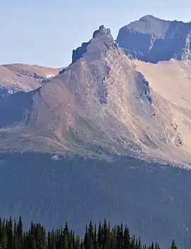 Trolltinder Mountain seen from Iceline Trail | |
| Highest point | |
| Elevation | 2,912 m (9,554 ft) [1] |
| Prominence | 112 m (367 ft) [1] |
| Listing | Mountains of British Columbia |
| Coordinates | 51°33′26″N 116°28′55″W [2] |
| Geography | |
 Trolltinder Mountain Location of Trolltinder Mountain in British Columbia  Trolltinder Mountain Trolltinder Mountain (Canada) | |
| Location | Yoho National Park British Columbia, Canada |
| Parent range | Waputik Range Canadian Rockies |
| Topo map | NTS 82N/09[2] |
| Geology | |
| Age of rock | Cambrian |
| Type of rock | Sedimentary |
| Climbing | |
| First ascent | 1901 J. Outram, E. Whymper, C. Kaufmann, C. Klucker, J. Pollinger[1] |
| Easiest route | Climbing Class 5 [1] |
History
The mountain was named by Jean Habel in 1897 for its resemblance to a mountain in Norway.[1] The translation is Witch's Peak.[3] [4] Jean Habel was a German geographer who explored the Yoho Valley in 1896.[5]
The first ascent of the mountain was made in 1901 by James Outram and Edward Whymper, with guides Christian Kaufmann, Christian Klucker, and Joseph Pollinger.[6] Outram described the climb in his book, "In the Heart of the Canadian Rockies" as follows: "On the 21st we had a little climb to a ruined tower on a serrated spur of Mt. Balfour, which had been called by Mr. Habel "Trolltinder," or the Witch's Peaks, after a famous and much pinnacled ridge above the Romsdal in Norway: the legend saying that the points represent a wedding party turned to stone by an evil genius. It was an absurdly simple climb, though somewhat laborious, except for the last fifty feet, which gave us a really good gymnastic scramble." [7]
The mountain's name was officially adopted in 1924 when approved by the Geographical Names Board of Canada.[2]
Geology
Trolltinder Mountain is composed of sedimentary rock laid down during the Precambrian to Jurassic periods.[8] Formed in shallow seas, this sedimentary rock was pushed east and over the top of younger rock during the Laramide orogeny.[9]
Climate
Based on the Köppen climate classification, Trolltinder Mountain is located in a subarctic climate zone with cold, snowy winters, and mild summers.[10] Temperatures can drop below −20 °C with wind chill factors below −30 °C.
See also
References
- "Trolltinder Mountain". Bivouac.com. Retrieved 2019-03-31.
- "Trolltinder Mountain". Geographical Names Data Base. Natural Resources Canada. Retrieved 2019-03-31.
- "Trolltinder Mountain". BC Geographical Names. Retrieved 2019-09-23.
- Chambers' Encyclopædia: A Dictionary of Universal Knowledge, page 796
- W., Boles, Glen (2006). Canadian mountain place names : the Rockies and Columbia Mountains. Laurilla, Roger W., 1959-, Putnam, William Lowell., Putnam, William Lowell. Place names of the Canadian Alps. Calgary, Alta.: Rocky Mountain Books. ISBN 9781894765794. OCLC 244770225.
- "Trolltinder Mountain". PeakFinder.com. Retrieved 2019-09-23.
- In the Heart of the Canadian Rockies, James Outram, Rocky Mountain Books, 2007
- Belyea, Helen R. (1960). The Story of the Mountains in Banff National Park (PDF). parkscanadahistory.com (Report). Ottawa: Geological Survey of Canada. Archived (PDF) from the original on 2015-10-02. Retrieved 2019-09-13.
- Gadd, Ben (2008). Geology of the Rocky Mountains and Columbias.
- Peel, M. C.; Finlayson, B. L.; McMahon, T. A. (2007). "Updated world map of the Köppen−Geiger climate classification". Hydrol. Earth Syst. Sci. 11: 1633–1644. ISSN 1027-5606.
External links
- Trolltinder Mountain weather forecast