Vermilion Peak (British Columbia)
Vermilion Peak is a 2,647-metre (8,684-foot) mountain summit located in the Vermilion River Valley of Kootenay National Park, in British Columbia, Canada. It is part of the Ball Range, which is a sub-range of the Canadian Rockies. Its nearest higher peak is Stanley Peak, 2.8 km (1.7 mi) to the east.[3] Vermilion Peak can be seen from the Banff–Windermere Parkway as it traverses the base of the mountain.
| Vermilion Peak | |
|---|---|
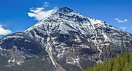 Vermilion Peak, north aspect | |
| Highest point | |
| Elevation | 2,647 m (8,684 ft) [1] |
| Prominence | 448 m (1,470 ft) [1] |
| Parent peak | Mount Ball (3294 m)[1] |
| Coordinates | 51°09′43″N 116°07′04″W [2] |
| Geography | |
 Vermilion Peak Location of Vermilion Peak in British Columbia  Vermilion Peak Vermilion Peak (Canada) | |
| Location | Kootenay National Park British Columbia, Canada |
| Parent range | Ball Range[3] Canadian Rockies |
| Topo map | NTS 82N/1 |
| Climbing | |
| Easiest route | Scrambling[4] |
History
Vermilion Peak stands to the east of the ochre beds along Ochre Creek that the Ktunaxa First Nations discovered and used for trading. The Ktunaxa would convert the ochre into red oxide, calling it vermilion.[5] Vermilion Peak takes its name from this. The mountain's name was officially adopted April 3, 1952, by the Geographical Names Board of Canada.[6]
Geology
Vermilion Peak is composed of drag-folded rocks of the Goodsir Group, a sedimentary rock laid down during the Precambrian to Jurassic periods and pushed east and over the top of younger rock during the Laramide orogeny.[7][8]
Climate
Based on the Köppen climate classification, Vermilion Peak has an alpine climate with cold, snowy winters, and mild summers.[9] Temperatures can drop below −20 °C with wind chill factors below −30 °C. Precipitation runoff from the mountain drains into tributaries of the Vermilion River.
References
- "Vermilion Peak". Bivouac.com. Retrieved 2020-01-25.
- "BC Geographical Names - Vermilion Peak". Retrieved 2020-01-26.
- "Vermilion Peak, British Columbia". Peakbagger.com.
- Alan Kane, "Scrambles in the Canadian Rockies", 3rd Ed, Rocky Mountain Books, 2016, pg 286.
- Vermilion Peak PeakFinder
- "Vermilion Peak". Geographical Names Data Base. Natural Resources Canada. Retrieved 2020-01-25.
- Gadd, Ben (2008). "Geology of the Rocky Mountains and Columbias". Cite journal requires
|journal=(help) - Parks Canada
- Peel, M. C.; Finlayson, B. L.; McMahon, T. A. (2007). "Updated world map of the Köppen−Geiger climate classification". Hydrol. Earth Syst. Sci. 11: 1633–1644. ISSN 1027-5606.
External links
- Parks Canada web site: Kootenay National Park
- Weather forecast: Vermilion Peak