Webster Springs, West Virginia
Addison, commonly known as Webster Springs, is a town in and the county seat of Webster County, West Virginia, United States. Although it was incorporated as Addison in 1892,[6] it is more frequently referred to as Webster Springs, the name of the town's post office.[1] It was named for Addison McLaughlin, upon whose land the town was originally laid out.[1] The population was 776 at the 2010 census.[7]
Webster Springs, West Virginia | |
|---|---|
| Addison, West Virginia | |
 | |
_Highlighted.svg.png.webp) Location of Addison (Webster Springs) in Webster County, West Virginia. | |
| Coordinates: 38°28′34″N 80°24′36″W | |
| Country | United States |
| State | West Virginia |
| County | Webster |
| Settled as: | Fort Lick in 1860 |
| Incorporated as (town): | Addison in 1892 |
| Named for | Addison McLaughlin[1] |
| Government | |
| • Mayor | Don E. McCourt |
| Area | |
| • Total | 0.47 sq mi (1.23 km2) |
| • Land | 0.45 sq mi (1.17 km2) |
| • Water | 0.02 sq mi (0.06 km2) |
| Elevation | 1,460 ft (445 m) |
| Population | |
| • Total | 776 |
| • Estimate (2019)[5] | 663 |
| • Density | 1,470.07/sq mi (568.16/km2) |
| Time zone | UTC-5 (Eastern (EST)) |
| • Summer (DST) | UTC-4 (EDT) |
| ZIP code | 26288 |
| Area code(s) | 304, 681 (beginning March 28, 2009) |
| FIPS code | 54101 |
| GNIS feature ID | 1560603 |
| Website | Addison Official Website |
The town was famous in the late 19th and early 20th centuries for its numerous salt sulfur water wells. People believed that the water from the wells had medicinal qualities.[6]
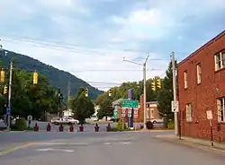
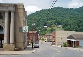
Webster Springs sits at the confluence of the Elk and Back Fork of the Elk Rivers. The town has numerous shops, retail stores, grocery stores, pharmacies, a motel, and several restaurants. Government offices for the municipality, county, and state are available in the town. The town is served by the Addison Public Library and fire service is provided by the Webster Springs Volunteer Fire Department.
Etymology
The name of the town is officially "Addison", but the community is most often referred to by the name of its post office, "Webster Springs".[8] It is also labeled on some maps as "Addison", and some as "Webster Springs". The unofficial name has gone so far that the county commission's letterhead reads "Webster Springs," rather than "Addison", which it had previously.
Other names for the town have included Elk Lick and Fork Lick.[8]
History
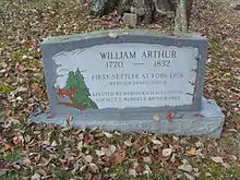
The town's first permanent settlers were named William and Polly (maiden name, "Friend") Arthur, who arrived in 1860.[6] The first post office established in Webster County was Fort Lick, present-day Webster Springs.[6] The postmaster at the time was a man by the name of John Hall. It is also the county seat of Webster County[6]
The Morton House was listed on the National Register of Historic Places in 1986.[9]
Salt sulfur wells
Hall, along with a man whose first name is not known, who is only known as Mr. Skidmore, drilled the first salt sulfur well in the county, it was known as "Old Spring."[6] The well was later owned by Colonel John T. McGraw.[6] The salt sulfur well helped make Webster Springs a popular summer tourist location during the 19th and early 20th Century.[6]
According to Springs in West Virginia, Webster Springs had a total of four springs: the Addison McLaughlin Well, located to the west of Court Square on the present site of the Mineral Springs Motel; Old Fork Lick Spring, located in the bed of the Elk River; Tracy Well, located on the lot of its owner, W.B. Tracy, in Webster Springs; and the William Smith Well, located in Dorrtown.[10] The wells were popular because people believed that the water from the wells had medicinal qualities.[6] The water was used to treat skin conditions such as psoriasis, eczema, acne and arthritis.[6]
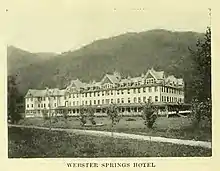
Webster Springs Hotel
In 1897, Senator Johnson Newlon Camden had built a 265-room hotel of Victorian style architecture,[11] which was larger than The Greenbrier Hotel built in 1913, which only has 250 rooms,[11] named the Webster Springs Hotel. The hotel contained a tennis court, horse stables, garden, bowling alley, power plant, and Russian and Turkish baths,[11] where visitors could enjoy the "medicinal" qualities of its salt sulfur waters. The hotel was also the largest wood frame hotel in West Virginia.[12]
When first built, the hotel was a three-story dark colored building. After it was completed, construction began on a new, much larger section of the hotel, adding more rooms, and a new exterior color, white. The new section of the hotel contained up-to-date Turkish bath equipment, where guests could have a sulfur water bath.[11] For many years, filled to capacity by guests and a greatly increased overflow which necessitated the building of smaller hotels in the town.[11] The hotel also raised its own cattle and provided some of its own food and milk.[11] The hotel's ice house, according to Elizah Hedding Gillespie, His Ancestors, Descendants and Their Families, was capable of holding 150 tons of ice.[11] The hotel was heated by steam.[11]
In 1903, Colonel McGraw purchased the hotel and expanded it by 115 rooms, completed in the spring of 1904.[11] Of the 89 "non-guest" rooms in the new section, 40 were for salt sulfur baths, which took up the entire first floor of one wing.[11] The entire southern wing of the hotel was given to bath rooms, including; "the plunge," Turkish, Russian, Needle, Shower, and Steam baths. Of which they were offered in both fresh and salt-sulfur water.[11]
On the interior, it contained stuffed bears, elks, and other wildlife of the local county in realistic poses.[11]
At the height of its popularity, the hotel played host to such guests as Senators Thomas Kearns (Utah), Henry G. Davis (West Virginia), his son-in-law, Senator Stephen Benton Elkins (West Virginia), and Camden (West Virginia).
On the night of July 20, 1925, the hotel caught fire and was burned to the ground, being completely destroyed.[11] Flames could be seen as far as one mile away, as well, the sky was seen as a bright red color, up to 19 miles away, in Camden-on-Gauley.[11]

Geography
Webster Springs is located at 38°28′34″N 80°24′36″W (38.476192, -80.410025), along the Elk River. According to the United States Census Bureau, the town has a total area of 0.47 square miles (1.22 km2), of which, 0.45 square miles (1.17 km2) is land and 0.02 square miles (0.05 km2) is water.[13] It is at an elevation of 1,460 ft. (445m).[3] It is close to Buffalo Bull Knob, elevation 2,799 ft.
Climate
The climate in this area has mild differences between highs and lows, and there is adequate rainfall year-round. According to the Köppen Climate Classification system, Webster Springs has a marine west coast climate, abbreviated "Cfb" on climate maps.[14]
Demographics
| Historical population | |||
|---|---|---|---|
| Census | Pop. | %± | |
| 1880 | 120 | — | |
| 1900 | 297 | — | |
| 1910 | 500 | 68.4% | |
| 1920 | 679 | 35.8% | |
| 1930 | 976 | 43.7% | |
| 1940 | 1,133 | 16.1% | |
| 1950 | 1,313 | 15.9% | |
| 1960 | 1,132 | −13.8% | |
| 1970 | 1,038 | −8.3% | |
| 1980 | 939 | −9.5% | |
| 1990 | 674 | −28.2% | |
| 2000 | 808 | 19.9% | |
| 2010 | 776 | −4.0% | |
| 2019 (est.) | 663 | [5] | −14.6% |
| U.S. Decennial Census[15] | |||
2000 census
As of the census of 2000, there were 808 people, 403 households, and 222 families living in the town. The population density was 1,729.9 inhabitants per square mile (663.8/km2). There were 463 housing units at an average density of 991.3 per square mile (380.4/km2). The racial makeup of the town was 99.75% White, 0.12% Native American, and 0.12% from two or more races. Hispanic or Latino of any race were 0.50% of the population.
There were 403 households, out of which 22.1% had children under the age of 18 living with them, 40.9% were married couples living together, 12.7% had a female householder with no husband present, and 44.7% were non-families. 42.2% of all households were made up of individuals, and 20.8% had someone living alone who was 65 years of age or older. The average household size was 2.00 and the average family size was 2.70.
In the town, the population was spread out, with 19.9% under the age of 18, 7.4% from 18 to 24, 24.4% from 25 to 44, 27.7% from 45 to 64, and 20.5% who were 65 years of age or older. The median age was 44 years. For every 100 females, there were 80.8 males. For every 100 females age 18 and over, there were 76.8 males.
The median income for a household in the town was $20,592, and the median income for a family was $27,434. Males had a median income of $27,386 versus $16,389 for females. The per capita income for the town was $13,500. About 22.0% of families and 28.1% of the population were below the poverty line, including 35.2% of those under age 18 and 21.9% of those age 65 or over.
2010 census
As of the census[4] of 2010, there were 776 people, 363 households, and 211 families living in the town. The population density was 1,724.4 inhabitants per square mile (665.8/km2). There were 447 housing units at an average density of 993.3 per square mile (383.5/km2). The racial makeup of the town was 99.2% White, 0.1% African American, 0.1% Native American, and 0.5% from two or more races. Hispanic or Latino of any race were 0.3% of the population.
There were 363 households, of which 27.0% had children under the age of 18 living with them, 40.8% were married couples living together, 13.2% had a female householder with no husband present, 4.1% had a male householder with no wife present, and 41.9% were non-families. 36.9% of all households were made up of individuals, and 14% had someone living alone who was 65 years of age or older. The average household size was 2.14 and the average family size was 2.77.
The median age in the town was 45.3 years. 20.6% of residents were under the age of 18; 7.1% were between the ages of 18 and 24; 22.3% were from 25 to 44; 32% were from 45 to 64; and 18% were 65 years of age or older. The gender makeup of the town was 47.8% male and 52.2% female.
Notable residents
- Joe Talbott,[16] Delegate for the 36th District
- Forest Dewey Dodrill, pioneering heart surgeon[17]
- Walt Helmick, West Virginia Commissioner of Agriculture.
See also
References
- Romano, Mark (2002). "Map of Webster County". A Pictorial History of Webster County (First ed.). Mark Romano. p. 203. ISBN 0-9720212-0-5.
- "2019 U.S. Gazetteer Files". United States Census Bureau. Retrieved August 7, 2020.
- "Geographic Names Information System (GNIS): Feature name: Webster Springs, West Virginia". United States Department of the Interior and United States Geological Survey. Retrieved 2008-12-26.
- "U.S. Census website". United States Census Bureau. Retrieved 2013-01-24.
- "Population and Housing Unit Estimates". United States Census Bureau. May 24, 2020. Retrieved May 27, 2020.
- Dilger, Dr. Robert Jay. "Webster County History". WVU.edu. Morgantown, West Virginia: West Virginia University. Retrieved 2008-12-26.
- "Addison (Webster Springs) town, West Virginia". American Fact Finder. United States Census Bureau. Archived from the original on 2020-02-10. Retrieved 2008-12-26.
- Romano, Mark (2007). ""The Historic Springs"". The Webster Springs Hotel and Historic Springs, WV: The Summer Resort Center (Limited Edition First ed.). Mark Romano. p. 15. ISBN 978-0-9720212-6-5.
- "National Register Information System". National Register of Historic Places. National Park Service. March 13, 2009.
- Romano, Mark (2007). "12, "The Historic Springs"". The Webster Springs Hotel and Historic Springs, WV: The Summer Resort Center (Limited Edition First ed.). Mark Romano. p. 58. ISBN 978-0-9720212-6-5.
- Romano, Mark (2007). ""The Historic Springs"". The Webster Springs Hotel and Historic Springs, WV: The Summer Resort Center (Limited Edition First ed.). Mark Romano. pp. 78–96. ISBN 978-0-9720212-6-5.
- Romano, Mark (2007). ""The Historic Springs"". The Webster Springs Hotel and Historic Springs, WV: The Summer Resort Center (Interview with Mae R. Cogar) (Limited Edition First ed.). Mark Romano. p. 97. ISBN 978-0-9720212-6-5.
- "US Gazetteer files 2010". United States Census Bureau. Retrieved 2013-01-24.
- Climate Summary for Webster Springs, West Virginia
- "Census of Population and Housing". Census.gov. Retrieved June 4, 2015.
- "West Virginia House of Delegates". West Virginia State Legislature. Retrieved 2008-12-26.
- Stephenson, Larry. "THE MICHIGAN HEART" (PDF). Retrieved 4 December 2013.
External links
| Wikimedia Commons has media related to Webster Springs, West Virginia. |
Municipalities and communities of Webster County, West Virginia, United States | ||
|---|---|---|
| Towns | 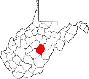 Map of West Virginia highlighting Webster County | |
| CDPs | ||
| Unincorporated communities |
| |
| Ghost towns | ||
| ||