Davy, West Virginia
Davy is a town in McDowell County, West Virginia, USA. The population was 420 at the 2010 census. An early variant name was Hallsville.[6] Davy was incorporated in 1948. It is a mostly residential community in a coal mining district along the main line of the Norfolk Southern Railway.
Davy, West Virginia | |
|---|---|
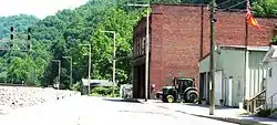 Main Street in Davy | |
 Location of Davy in McDowell County, West Virginia. | |
| Coordinates: 37°28′47″N 81°39′0″W | |
| Country | United States |
| State | West Virginia |
| County | McDowell |
| Area | |
| • Total | 1.29 sq mi (3.35 km2) |
| • Land | 1.27 sq mi (3.30 km2) |
| • Water | 0.02 sq mi (0.06 km2) |
| Elevation | 1,184 ft (361 m) |
| Population | |
| • Total | 420 |
| • Estimate (2019)[3] | 337 |
| • Density | 264.73/sq mi (102.21/km2) |
| Time zone | UTC-5 (Eastern (EST)) |
| • Summer (DST) | UTC-4 (EDT) |
| ZIP code | 24828 |
| Area code(s) | 304 |
| FIPS code | 54-20500[4] |
| GNIS feature ID | 1538061[5] |
Geography
According to the United States Census Bureau, the town has a total area of 1.29 square miles (3.34 km2), of which, 1.27 square miles (3.29 km2) is land and 0.02 square miles (0.05 km2) is water.[7]
Demographics
| Historical population | |||
|---|---|---|---|
| Census | Pop. | %± | |
| 1950 | 1,650 | — | |
| 1960 | 1,331 | −19.3% | |
| 1970 | 993 | −25.4% | |
| 1980 | 882 | −11.2% | |
| 1990 | 403 | −54.3% | |
| 2000 | 373 | −7.4% | |
| 2010 | 420 | 12.6% | |
| 2019 (est.) | 337 | [3] | −19.8% |
| U.S. Decennial Census[8] | |||
2010 census
At the 2010 census there were 420 people, 167 households, and 123 families living in the town. The population density was 330.7 inhabitants per square mile (127.7/km2). There were 192 housing units at an average density of 151.2 per square mile (58.4/km2). The racial makeup of the town was 96.7% White, 2.6% African American, 0.2% Native American, and 0.5% from two or more races.[2] Of the 167 households 33.5% had children under the age of 18 living with them, 51.5% were married couples living together, 14.4% had a female householder with no husband present, 7.8% had a male householder with no wife present, and 26.3% were non-families. 24.6% of households were one person and 12.6% were one person aged 65 or older. The average household size was 2.51 and the average family size was 2.94.
The median age in the town was 40 years. 22.6% of residents were under the age of 18; 8.8% were between the ages of 18 and 24; 27.2% were from 25 to 44; 26.7% were from 45 to 64; and 14.8% were 65 or older. The gender makeup of the town was 51.4% male and 48.6% female.
2000 census
At the 2000 census there were 373 people, 137 households, and 106 families living in the town. The population density was 288.8 inhabitants per square mile (111.5/km2). There were 170 housing units at an average density of 131.6 per square mile (50.8/km2). The racial makeup of the town was 99.73% White and 0.27% Pacific Islander.[4] Of the 137 households 29.9% had children under the age of 18 living with them, 59.1% were married couples living together, 13.1% had a female householder with no husband present, and 22.6% were non-families. 21.2% of households were one person and 10.2% were one person aged 65 or older. The average household size was 2.72 and the average family size was 3.13.
The age distribution was 23.9% under the age of 18, 8.8% from 18 to 24, 28.7% from 25 to 44, 26.8% from 45 to 64, and 11.8% 65 or older. The median age was 37 years. For every 100 females, there were 90.3 males. For every 100 females age 18 and over, there were 85.6 males.
The median household income was $16,250 and the median family income was $23,000. Males had a median income of $15,417 versus $13,750 for females. The per capita income for the town was $8,116. About 37.3% of families and 41.8% of the population were below the poverty line, including 60.0% of those under age 18 and 15.4% of those age 65 or over.
References
- "2019 U.S. Gazetteer Files". United States Census Bureau. Retrieved August 7, 2020.
- "U.S. Census website". United States Census Bureau. Retrieved 2013-01-24.
- "Population and Housing Unit Estimates". United States Census Bureau. May 24, 2020. Retrieved May 27, 2020.
- "U.S. Census website". United States Census Bureau. Retrieved 2008-01-31.
- "US Board on Geographic Names". United States Geological Survey. 2007-10-25. Retrieved 2008-01-31.
- Kenny, Hamill (1945). West Virginia Place Names: Their Origin and Meaning, Including the Nomenclature of the Streams and Mountains. Piedmont, WV: The Place Name Press. p. 202.
- "US Gazetteer files 2010". United States Census Bureau. Archived from the original on 2012-01-25. Retrieved 2013-01-24.
- "Census of Population and Housing". Census.gov. Retrieved June 4, 2015.
Municipalities and communities of McDowell County, West Virginia, United States | ||
|---|---|---|
| Cities | 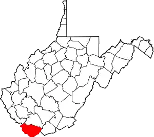 Map of West Virginia highlighting McDowell County | |
| Towns | ||
| CDPs | ||
| Unincorporated communities |
| |
| Ghost town | ||
| Footnotes | ‡This populated place also has portions in an adjacent county or counties | |
| ||