Moundsville, West Virginia
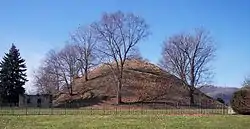
Moundsville is a city in Marshall County, West Virginia, along the Ohio River. It is part of the Wheeling, West Virginia metropolitan area. The population was 9,318 at the 2010 census. It is the county seat of Marshall County.[5] The city was named for the nearby ancient Grave Creek Mound, constructed 250 to 100 BC by indigenous people of the Adena culture.[6]
Moundsville, West Virginia | |
|---|---|
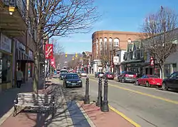 Jefferson Avenue in downtown Moundsville in 2006 | |
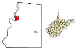 Location of Moundsville in Marshall County, West Virginia. | |
| Coordinates: 39°55′17″N 80°44′22″W | |
| Country | United States |
| State | West Virginia |
| County | Marshall |
| Area | |
| • Total | 3.36 sq mi (8.70 km2) |
| • Land | 2.91 sq mi (7.53 km2) |
| • Water | 0.45 sq mi (1.17 km2) |
| Elevation | 696 ft (212 m) |
| Population | |
| • Total | 9,318 |
| • Estimate (2019)[3] | 8,252 |
| • Density | 2,838.67/sq mi (1,096.20/km2) |
| Time zone | UTC-5 (Eastern (EST)) |
| • Summer (DST) | UTC-4 (EDT) |
| ZIP code | 26041 |
| Area code(s) | 304 |
| FIPS code | 54-56020 |
| GNIS feature ID | 1543607[4] |
| Website | http://www.cityofmoundsville.com/ |
History
In 1771 by English colonists Samuel and James Tomlinson built a cabin at what later became Moundsville, although they did not overwinter, and in fact left for several years after attacks by Native Americans. Elizabethtown, as Tomlinson's community was called, was incorporated in 1830 and would become the county seat upon the creation of Marshall County in 1835. Nearby, the town of Mound City was incorporated in 1832. The two towns combined in 1865.[7] In 1852 a llne of the Baltimore and Ohio Railroad opened, connecting the eastern rail network with the Ohio and Mississippi riverboat system; Moundsville was an important port until 1861, when the Civil War shut down the river system and caused major damage to the railroad. Fostoria Glass Company (specializing in hand-blown glassworks) was headquartered in Moundsville from 1891 to 1986. The retired West Virginia State Penitentiary operated in Moundsville from 1867 to 1995.[8] On August 4, 1927, Charles Lindbergh landed The Spirit of St. Louis at Langin Field in Moundsville.[9]
Geography
According to the United States Census Bureau, the city has a total area of 3.36 square miles (8.70 km2), of which, 2.91 square miles (7.54 km2) is land and 0.45 square miles (1.17 km2) is water.[10]
Climate
The climate in this area is characterized by relatively high temperatures and evenly distributed precipitation throughout the year. According to the Köppen Climate Classification system, Moundsville has a Humid subtropical climate, abbreviated "Cfa" on climate maps.[11]
| Climate data for Moundsville, West Virginia | |||||||||||||
|---|---|---|---|---|---|---|---|---|---|---|---|---|---|
| Month | Jan | Feb | Mar | Apr | May | Jun | Jul | Aug | Sep | Oct | Nov | Dec | Year |
| Average high °C (°F) | 4 (39) |
6 (42) |
12 (53) |
19 (66) |
24 (75) |
28 (82) |
30 (86) |
29 (85) |
26 (78) |
19 (67) |
13 (55) |
6 (43) |
18 (64) |
| Average low °C (°F) | −7 (20) |
−6 (22) |
−1 (30) |
4 (39) |
9 (49) |
14 (58) |
17 (62) |
16 (61) |
12 (54) |
6 (42) |
1 (34) |
−3 (26) |
5 (41) |
| Average precipitation cm (inches) | 7.6 (3) |
5.8 (2.3) |
8.6 (3.4) |
9.1 (3.6) |
11 (4.3) |
11 (4.4) |
11 (4.3) |
10 (4) |
8.1 (3.2) |
6.9 (2.7) |
8.6 (3.4) |
7.9 (3.1) |
106 (41.7) |
| Source: Weatherbase [12] | |||||||||||||
Demographics
| Historical population | |||
|---|---|---|---|
| Census | Pop. | %± | |
| 1850 | 445 | — | |
| 1860 | 515 | 15.7% | |
| 1870 | 1,500 | 191.3% | |
| 1880 | 1,774 | 18.3% | |
| 1890 | 2,688 | 51.5% | |
| 1900 | 5,362 | 99.5% | |
| 1910 | 8,918 | 66.3% | |
| 1920 | 10,669 | 19.6% | |
| 1930 | 14,411 | 35.1% | |
| 1940 | 14,168 | −1.7% | |
| 1950 | 14,772 | 4.3% | |
| 1960 | 15,163 | 2.6% | |
| 1970 | 13,560 | −10.6% | |
| 1980 | 12,419 | −8.4% | |
| 1990 | 10,753 | −13.4% | |
| 2000 | 9,998 | −7.0% | |
| 2010 | 9,318 | −6.8% | |
| 2019 (est.) | 8,252 | [3] | −11.4% |
| U.S. Decennial Census[13] 2014 Estimate[14] | |||
2010 census
As of the census[2] of 2010, there were 9,318 people, 4,016 households, and 2,445 families living in the city. The population density was 3,202.1 inhabitants per square mile (1,236.3/km2). There were 4,458 housing units at an average density of 1,532.0 per square mile (591.5/km2). The racial makeup of the city was 97.5% White, 0.8% African American, 0.2% Native American, 0.4% Asian, 0.2% from other races, and 0.9% from two or more races. Hispanic or Latino of any race were 1.1% of the population.
There were 4,016 households, of which 25.4% had children under the age of 18 living with them, 41.2% were married couples living together, 14.5% had a female householder with no husband present, 5.1% had a male householder with no wife present, and 39.1% were non-families. 33.7% of all households were made up of individuals, and 16.4% had someone living alone who was 65 years of age or older. The average household size was 2.21 and the average family size was 2.79.
The median age in the city was 45.2 years. 19.4% of residents were under the age of 18; 7.1% were between the ages of 18 and 24; 23.2% were from 25 to 44; 30.1% were from 45 to 64; and 20.1% were 65 years of age or older. The gender makeup of the city was 47.9% male and 52.1% female.
2000 census
As of the census of 2000, there were 9,998 people, 4,122 households, and 2,662 families living in the city. The population density was 3,399.0 people per square mile (1,313.0/km2). There were 4,461 housing units at an average density of 1,516.6 per square mile (585.9/km2). The racial makeup of the city was 98.13% White, 0.73% African American, 0.13% Native American, 0.30% Asian, 0.01% Pacific Islander, 0.10% from other races, and 0.60% from two or more races. Hispanic or Latino of any race were 1.16% of the population.
There were 4,122 households, out of which 25.5% had children under the age of 18 living with them, 47.7% were married couples living together, 13.3% had a female householder with no husband present, and 35.4% were non-families. 31.4% of all households were made up of individuals, and 17.0% had someone living alone who was 65 years of age or older. The average household size was 2.28 and the average family size was 2.84.
In the city the population was spread out, with 20.4% under the age of 18, 7.8% from 18 to 24, 26.8% from 25 to 44, 24.9% from 45 to 64, and 20.0% who were 65 years of age or older. The median age was 42 years. For every 100 females, there were 92.3 males. For every 100 females age 18 and over, there were 89.0 males.
The median income for a household in the city was $23,107, and the median income for a family was $30,534. Males had a median income of $26,242 versus $19,348 for females. The per capita income for the city was $13,997. About 18.1% of families and 22.4% of the population were below the poverty line, including 33.2% of those under age 18 and 15.5% of those age 65 or over.
Notable people
- Steve Crabtree, Republican politician and media personality
- Frank De Vol, film and television music composer and actor
- Cadency, Youtuber
- Virginia B. Evans, painter, glass artist, and teacher
- Joseph W. Gallaher, businessman and politician
- Davis Grubb, novelist and story writer
- Kristin Lewicki, professional ice hockey player
- Adrian Melott, astrophysicist and astrobiologist
- Arch A. Moore, Jr., former Governor of West Virginia
- Ed Pastilong, football player, coach, and college athletics administrator, WVU's Director of Athletics for 21 years
- Ted Valentine, NCAA men's basketball referee and 2005 Naismith College Official of the Year.
Gallery
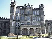 West Virginia State Penitentiary.
In popular culture
In 2018, documentary filmmakers David Bernabo and John W. Miller released Moundsville,[15] a documentary about the history of Moundsville.
References
- "2019 U.S. Gazetteer Files". United States Census Bureau. Retrieved August 7, 2020.
- "U.S. Census website". United States Census Bureau. Retrieved 2013-01-24.
- "Population and Housing Unit Estimates". United States Census Bureau. May 24, 2020. Retrieved May 27, 2020.
- "US Board on Geographic Names". United States Geological Survey. 2007-10-25. Retrieved 2008-01-31.
- "Find a County". National Association of Counties. Retrieved 2011-06-07.
- Comins, Linda S. (2006). "Moundsville". In Ken Sullivan (ed.). The West Virginia Encyclopedia. Charleston, W.Va.: West Virginia Humanities Council. p. 505. ISBN 0-9778498-0-5.
- Marshall County Historical Society. History of Marshall County, West Virginia. Marceline, Mo.: Walsworth, 1984. p. 975.416 M367m.
- Bumgardner, Stan (2006). "Moundsville Penitentiary". In Ken Sullivan (ed.). The West Virginia Encyclopedia. Charleston, W.Va.: West Virginia Humanities Council. p. 505. ISBN 0-9778498-0-5.
- http://www.wvculture.org/history/thisdayinwvhistory/0804.html
- "US Gazetteer files 2010". United States Census Bureau. Archived from the original on 2012-07-02. Retrieved 2013-01-24.
- Climate Summary for Moundsville, West, Virginia
- "Weatherbase.com". Weatherbase. 2013. Retrieved on September 14, 2013.
- United States Census Bureau. "Census of Population and Housing". Retrieved August 27, 2013.
- "Population Estimates". United States Census Bureau. Archived from the original on May 22, 2015. Retrieved June 19, 2015.
- Edinger, Nora. ""Moundsville" — the Happy, the Sad, the Past, the Future Summed Up in Documentary – Weelunk". Retrieved 2019-01-12.
External links
| Wikimedia Commons has media related to Moundsville, West Virginia. |
- City's official website
- Chisholm, Hugh, ed. (1911). . Encyclopædia Britannica (11th ed.). Cambridge University Press.
Municipalities and communities of Marshall County, West Virginia, United States | ||
|---|---|---|
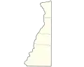
| Cities | 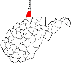 Map of West Virginia highlighting Marshall County | |
| Unincorporated communities |
| |
| Ghost towns | ||
| Footnotes | ‡This populated place also has portions in an adjacent county or counties | |
| ||
| Authority control |
|---|