White Pyramid (Banff)
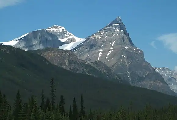
White Pyramid is a 3,219 metres (10,561 ft) mountain summit located between the Howse River valley and Mistaya River valley of Banff National Park, in the Canadian Rockies of Alberta, Canada. Its nearest higher peak is Howse Peak, 3.00 km (1.86 mi) to the south.[1] White Pyramid is visible from the Icefields Parkway in the vicinity of Waterfowl Lakes.
| White Pyramid | |
|---|---|
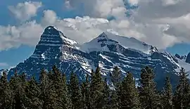 White Pyramid (right) and Mount Chephren (left) seen from north along the Icefields Parkway | |
| Highest point | |
| Elevation | 3,219 m (10,561 ft) [1] |
| Prominence | 236 m (774 ft) [1] |
| Parent peak | Howse Peak (3295 m)[1] |
| Coordinates | 51°50′08″N 116°41′40″W [2] |
| Geography | |
 White Pyramid Location of White Pyramid in Alberta  White Pyramid White Pyramid (Canada) | |
| Location | Banff National Park Alberta, Canada |
| Parent range | Waputik Mountains Canadian Rockies |
| Topo map | NTS 82N15[2] |
| Geology | |
| Age of rock | Cambrian |
| Type of rock | Sedimentary |
| Climbing | |
| First ascent | 1939 Katie Gardiner, Edward Feuz Jr. (guide)[3] |
History
It was named in 1901 by J. Norman Collie to distinguish it from Mount Chephren, which back then was named Pyramid Mountain.[3] The two peaks are nearly the same in height, and separated by only one kilometre. However, White Pyramid has a glacier on its north aspect, which Chephren does not.
The first ascent of White Pyramid was made in 1939 by Kate (Katie) Gardiner and guide Edward Feuz Jr.[3] The climbing duo made many first ascents in the Canadian Rockies during the 1930s.[4]
The mountain's name was made official in 1961 when approved by the Geographical Names Board of Canada.[2]
Geology
Like other mountains in Banff Park, White Pyramid is composed of sedimentary rock laid down during the Precambrian to Jurassic periods.[5] Formed in shallow seas, this sedimentary rock was pushed east and over the top of younger rock during the Laramide orogeny.[6]
Climate
Based on the Köppen climate classification, White Pyramid is located in a subarctic climate with cold, snowy winters, and mild summers.[7] Temperatures can drop below -20 °C with wind chill factors below -30 °C. Precipitation runoff from White Pyramid drains into the Mistaya River and Howse River which are both tributaries of the North Saskatchewan River.
References
- "White Pyramid". Bivouac.com. Retrieved 2019-02-12.
- "White Pyramid". Geographical Names Data Base. Natural Resources Canada. Retrieved 2019-02-11.
- "White Pyramid". PeakFinder.com. Retrieved 2019-08-02.
- "Katie Gardner". PeakFinder.com. Retrieved 2019-08-02.
-
Belyea, Helen (1960). "The Story of the Mountains in Banff National Park" (PDF). Geological Survey of Canada. Archived (PDF) from the original on 2 October 2015. Retrieved 2019-06-23. Cite journal requires
|journal=(help) - Gadd, Ben (2008). "Geology of the Rocky Mountains and Columbias". Cite journal requires
|journal=(help) - Peel, M. C.; Finlayson, B. L.; McMahon, T. A. (2007). "Updated world map of the Köppen−Geiger climate classification". Hydrol. Earth Syst. Sci. 11: 1633–1644. ISSN 1027-5606.
See also
External links
- Parks Canada web site: Banff National Park
- White Pyramid weather: Mountain Forecast