Yerriyong
Yerriyong is a locality in the City of Shoalhaven in New South Wales, Australia.[2][3] It lies about 17 km to the southwest of Nowra on the road to Nerriga and Canberra. It is largely made up of eucalyptus forest. At the 2016 census, it had a population of 25.[1]
| Yerriyong New South Wales | |||||||||||||||
|---|---|---|---|---|---|---|---|---|---|---|---|---|---|---|---|
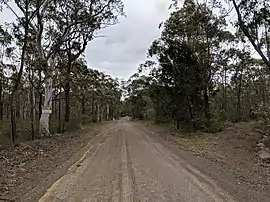 Road in Yerriyong | |||||||||||||||
Yerriyong Location in New South Wales | |||||||||||||||
| Coordinates | 34°59′36″S 150°29′05″E | ||||||||||||||
| Population | 25 (2016 census)[1] | ||||||||||||||
| Postcode(s) | 2540 | ||||||||||||||
| Location | |||||||||||||||
| LGA(s) | City of Shoalhaven | ||||||||||||||
| Region | South Coast | ||||||||||||||
| County | St Vincent | ||||||||||||||
| Parish | Yerriyong | ||||||||||||||
| State electorate(s) | Kiama | ||||||||||||||
| Federal Division(s) | Gilmore | ||||||||||||||
| |||||||||||||||
The name is believed to be of Aboriginal origin, as in Tharawal "Yerri" means "tooth" and "ong" is a common place name ending, so it is considered to relate to an initiation ceremony.[2]
Yerriyong had a state school from 1885 to 1948. This was described as a "provisional school" (October 1882–April 1883), "public school" (1883–1895), or "half-time school" (June–September 1895).[4] It was replaced by Yerriyong Vale, which was a "half-time school" (June–September 1895, 1906–1908 and 1914–1916) or a "provisional school" (1895–1906 and 1909–1913).[5]
References
- Australian Bureau of Statistics (27 June 2017). "Yerriyong". 2016 Census QuickStats. Retrieved 5 December 2018.

- "Yerriyong". Geographical Names Register (GNR) of NSW. Geographical Names Board of New South Wales. Retrieved 5 December 2018.
- "Yerriyong". OpenStreetMap. Retrieved 5 December 2018.
- "Yerriyong in the School history database search". New South Wales Department of Education. Retrieved 5 December 2018.
- "Yerriyong Vale in the School history database search". New South Wales Department of Education. Retrieved 5 December 2018.
