City of Shoalhaven
The City of Shoalhaven is a local government area in the south-eastern coastal region of New South Wales, Australia. The area is approximately 200 kilometres (120 mi) south of Sydney. The area is located adjacent to the Tasman Sea. The Princes Highway passes through the area and the South Coast railway line traverses the northern section of the area and terminates at Bomaderry. At the 2016 census, the population of the City of Shoalhaven was 99,650.[1]
| City of Shoalhaven New South Wales | |||||||||||||||
|---|---|---|---|---|---|---|---|---|---|---|---|---|---|---|---|
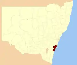 Location in NSW | |||||||||||||||
| Coordinates | 35°07′S 150°30′E | ||||||||||||||
| Population |
| ||||||||||||||
| • Density | 21.820/km2 (56.512/sq mi) | ||||||||||||||
| Established | 1 July 1948 | ||||||||||||||
| Area | 4,567 km2 (1,763.3 sq mi) | ||||||||||||||
| Mayor | Amanda Findley | ||||||||||||||
| Council seat | Nowra[3] | ||||||||||||||
| Region | South Coast | ||||||||||||||
| State electorate(s) | |||||||||||||||
| Federal Division(s) | Gilmore | ||||||||||||||
| Website | City of Shoalhaven | ||||||||||||||
| |||||||||||||||
The City was established on 1 July 1948 as the Shoalhaven Shire following the amalgamation of the Municipalities of Nowra, Berry, Broughton’s Vale, Ulladulla, South Shoalhaven, and the shires of Cambewarra and Clyde.[4]
The Mayor of Shoalhaven City Council is Amanda Findley, who is a member of the Greens. She defeated the incumbent mayor Joanna Gash on preferences at the 2016 elections.
History
Modern-day groupings of the Illawarra and South Coast Aboriginal peoples are based on information compiled by white anthropologists from the late 1870s. Two divisions were initially presented (refer Ridley, 1878), using geographical location and language, though these criteria are now expanded into five divisions and given Aboriginal names, as follows (after C.Sefton, 1983):
*Dharawal - general name for the Aboriginal people of the area on the east coast of New South Wales from Botany Bay to Shoalhaven, and west to Berrima and Camden.
*Wodi-Wodi (or Wadi-Wadi) - a subdivision of Thuruwal, includes the Aboriginal people of the coast from Wollongong to Shoalhaven.
*Gurandada and Tharumba (or Dharumba) - those people living around the Shoalhaven River.
The Jerrinja people record their traditional lands as stretching from Crooked River in the north to Clyde River in the south, from the mountains to the sea at Roseby Park.[5]
George Bass explored the area in 1797, following Seven Mile Beach. He crossed the shoals at the entrance to the river, calling it "Shoals Haven" due to the shallowness of the river mouth. This river is now known as the Crookhaven,[6] but the name was adopted for the Shoalhaven area and the Shoalhaven River.
Towns and localities
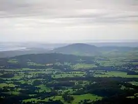
Shoalhaven, although designated a city, is a dispersed region spread over 125 kilometres (78 mi) of coastline, with the vast majority of its population located in the north-east around Nowra, Jervis Bay and Sussex Inlet.
It includes the following towns, suburbs and localities:
Localities with no population in 2016 included:
|
|
Council
.jpg.webp)
Current composition and election method
Shoalhaven City Council is composed of thirteen Councillors, including the Mayor, for a fixed four-year term of office. The Mayor is directly elected while the twelve other Councillors are elected proportionally as three separate wards, each electing four Councillors. The most recent election was held on 10 September 2016, and the makeup of the Council, including the Mayor, is in order of elected and as follows:[7]
| Party | Councillors | |
|---|---|---|
| Shoalhaven Independents Group | 5 | |
| Greens | 4 | |
| Team Gash | 3 | |
| Labor | 1 | |
| Total | 13 | |
The current Council, elected in 2016, in order of election by ward, is:
| Ward | Councillor | Party | Notes | |
|---|---|---|---|---|
| Mayor[8] | Amanda Findley | Greens | ||
| Ward One[9] | Andrew Guile | Shoalhaven Independents Group | ||
| John Wells | Team Gash | |||
| Nina Cheyne | Greens | |||
| Annette Alldrick | Labor | |||
| Ward Two[10] | Greg Watson | Shoalhaven Independents Group | ||
| Jo Gash | Team Gash | Former Federal MP for Gilmore. | ||
| John Levett | Greens | |||
| Mitchell Pakes | Shoalhaven Independents Group | |||
| Ward Three[11] | Mark Kitchener | Shoalhaven Independents Group | ||
| Patricia White | Team Gash | Deputy Mayor | ||
| Bob Proudfoot | Shoalhaven Independents Group | |||
| Kaye Gartner | Greens | |||
Tourism and culture
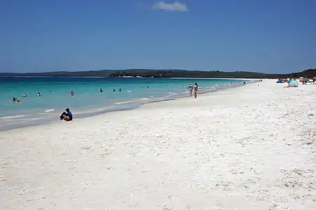
The Shoalhaven can be reached from Sydney by car via the Princes Highway and by rail via the South Coast railway line which terminates just north of Nowra at Bomaderry. The Shoalhaven is adjacent to the Jervis Bay Territory. The area is approximately 160 kilometres (99 mi) long along the coastline, including 109 beaches, which allegedly possesses the whitest sand in the world, as well as pristine natural Australian bushland. The Shoalhaven area is home to numerous species of native Australian flora and fauna.[12]
The area is well known for its strong commitment to the arts and music, featuring the See Change and See Celebrations festivals in the Jervis Bay and St Georges Basin areas, as well as the EscapeArtfest festival and Blessing of the Fleet in the Ulladulla area.[13]
Tourists to Shoalhaven can enjoy a wealth of cultural and nature-based activities and experiences, including whale-watching, kayaking, visiting beaches and tastings at wineries.[14] Some of the most famous establishments for visitors in Shoalhaven are Rick Stein at Bannisters, Cupitt's Estate and Coolangatta Estate.
Heritage listings
Heritage listings for the City of Shoalhaven include:
- Bherwerre Beach, Wreck Bay: Hive shipwreck[15]
See also
References
- Australian Bureau of Statistics (27 June 2017). "Shoalhaven (C)". 2016 Census QuickStats. Retrieved 9 July 2017.

- "3218.0 – Regional Population Growth, Australia, 2017-18". Australian Bureau of Statistics. 27 March 2019. Retrieved 27 March 2019. Estimated resident population (ERP) at 30 June 2018.
- "Shoalhaven City Council". Department of Local Government. Archived from the original on 7 September 2006. Retrieved 26 November 2006.
- "Municipality of Nowra". Search. State Records NSW. Archived from the original on 3 June 2016. Retrieved 21 May 2016.
- "The Jerrinja tribe and the Shoalhaven – New Bush Telegraph". New Bush Telegraph – Shoalhaven, NSW. 17 February 2020. Retrieved 5 March 2020.
- "NSW Police Regions and History". Nowra Police Station. Archived from the original on 6 March 2011. Retrieved 29 April 2008.
- http://vtr.elections.nsw.gov.au/shoalhaven-city-council
- http://vtr.elections.nsw.gov.au/shoalhaven-city-council/mayoral
- http://vtr.elections.nsw.gov.au/shoalhaven-city-council/ward-1
- http://vtr.elections.nsw.gov.au/shoalhaven-city-council/ward-2
- http://vtr.elections.nsw.gov.au/shoalhaven-city-council/ward-3
- "Jervis Bay & Shoalhaven". Visit NSW. Retrieved 11 May 2013.
- "Arts in Shoalhaven". Geoff Bolton. October 2012. Retrieved 6 October 2012.
- Kelly, Chris. "The Weekender: Shoalhaven, NSW". Hunter and Bligh. Retrieved 29 September 2020.
- "Hive Shipwreck". New South Wales State Heritage Register. Office of Environment and Heritage. H01812. Retrieved 2 June 2018.
| Capital | |
|---|---|
| Cities | |
| Cities | |
|---|---|
| Towns & Townships |
|
| Local government areas | |
| National parks | |
| Rivers and other waterbodies | |