Bellawongarah
Bellawongarah is a locality in the City of Shoalhaven in New South Wales, Australia.[2][3] It lies west of the Princes Highway on the Kangaroo Valley Road between Berry and Kangaroo Valley. It lies about 23 kilometre north of Nowra and about 160 km south of Sydney. At the 2016 census, it had a population of 127.[1] It lies on a ridge and is partly covered by temperate rain forest and partly by grasslands that were formerly used for dairying, but are now mainly used for rural residences.
| Bellawongarah New South Wales | |||||||||||||||
|---|---|---|---|---|---|---|---|---|---|---|---|---|---|---|---|
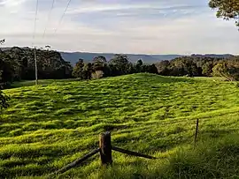 Bellawongarah with Illawarra escarpment in the background | |||||||||||||||
Bellawongarah Location in New South Wales | |||||||||||||||
| Coordinates | 34°45′57″S 150°37′02″E | ||||||||||||||
| Population | 127 (2016 census)[1] | ||||||||||||||
| Postcode(s) | 2535 | ||||||||||||||
| Location | |||||||||||||||
| LGA(s) | City of Shoalhaven | ||||||||||||||
| Region | South Coast | ||||||||||||||
| County | Camden | ||||||||||||||
| Parish | Cambewarra | ||||||||||||||
| State electorate(s) | Kiama | ||||||||||||||
| Federal Division(s) | Gilmore | ||||||||||||||
| |||||||||||||||
Bellawongarah had a state school from 1874 to 1944. It was variously described as a "public", "provisional" or "half-time".[4]
References
- Australian Bureau of Statistics (27 June 2017). "Bellawongarah". 2016 Census QuickStats. Retrieved 5 May 2018.

- "Bellawongarah". Geographical Names Register (GNR) of NSW. Geographical Names Board of New South Wales. Retrieved 5 May 2018.
- "Bellawongarah". OpenStreetMap. Retrieved 5 May 2018.
- "Bellawongarah in the School history database search". New South Wales Department of Education. Retrieved 5 May 2018.
| Cities | |
|---|---|
| Towns & Townships |
|
| Local government areas | |
| National parks | |
| Rivers and other waterbodies | |
This article is issued from Wikipedia. The text is licensed under Creative Commons - Attribution - Sharealike. Additional terms may apply for the media files.