1964 Atlantic hurricane season
The 1964 Atlantic hurricane season featured the highest number of U.S.-landfalling hurricanes since 1933.[1] The season officially began on June 15, and lasted until November 30. These dates conventionally delimit the period of each year when most tropical cyclones form in the Atlantic basin. The season was above average, with thirteen named storms, seven hurricanes, and five major hurricanes. The first system, an unnamed tropical storm, developed on June 2, almost two weeks before the official start of the season. Striking Florida on June 6, the storm brought localized flooding to portions of Cuba and the Southeastern United States, leaving about $1 million in damage. The next storm, also unnamed, developed near the end of July; it did not impact land.
| 1964 Atlantic hurricane season | |
|---|---|
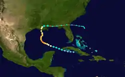
 Season summary map | |
| Seasonal boundaries | |
| First system formed | June 2, 1964 |
| Last system dissipated | November 10, 1964 |
| Strongest storm | |
| Name | Cleo |
| • Maximum winds | 150 mph (240 km/h) (1-minute sustained) |
| • Lowest pressure | 938 mbar (hPa; 27.7 inHg) |
| Seasonal statistics | |
| Total depressions | 15 |
| Total storms | 13 |
| Hurricanes | 7 |
| Major hurricanes (Cat. 3+) | 5 |
| Total fatalities | 270 |
| Total damage | ~ $629.63 million (1964 USD) |
| Related articles | |
The effects of Hurricanes Cleo, Dora, and Isbell combined were devastating to Florida. Cleo also brought destruction to portions of the Caribbean, especially Guadeloupe and Haiti. After moving inland, Cleo brought flooding to states such as Virginia. Overall, the storm caused 219 deaths and about $187.5 million in damage.[nb 1] Dora lashed much of North Florida and southeastern Georgia with hurricane-force winds, leaving five fatalities and around $280 million in damage. In October, Isbell brought strong winds and several tornadoes to Florida, as well as flooding to Cuba and The Carolinas. Isbell killed seven people and left approximately $30 million in damage.
The strongest tropical cyclone of the season was Hurricane Cleo, a powerful Category 4 hurricane that severely affected areas in the Caribbean, including the Leeward Islands, Haiti, and Cuba. Cleo went on to hit the United States, in the eastern Florida peninsula as a minimal Category 2 hurricane, particularly in Miami, Florida, where the storm brought severe damage to the state alone, and bringing heavy rain, and severe flooding to the Carolinas in the United States East Coast as a tropical storm. The names Cleo, Dora, and Hilda were retired following the season. Collectively, the tropical cyclones resulted in 270 fatalities and approximately $629.63 million in damage.
Season summary


The Atlantic hurricane season officially began on June 15, 1964.[2] It was a slightly above average season in which twelve tropical storms formed,[3] compared with the 1950–2000 average of 9.6 named storms.[4] Six of these reached hurricane status,[3] which is near the 1950–2000 average of 5.9.[4] All six of the hurricanes reached major hurricane status – well above the 1950–2000 mean of 2.3 per season.[4] Prior to the season, National Hurricane Center Director Gordon Dunn noted that the probability of a hurricane striking the United States was "astronomical."[5] Four hurricanes and three tropical storms made landfall during the season, causing at least 270 deaths and $629.63 million in damage. Tropical Storm Brenda and Hurricane Gladys also caused damage and fatalities, but neither struck land.[6] The season officially ended on November 30, 1964.[2]
The first system, an unnamed tropical storm, developed on June 2,[3] 13 days before the start of the season.[2] It struck Florida as a tropical depression and then strengthened into a tropical storm while out at sea. The storm ceased to exist on June 11. Thereafter, the season went dormant for nearly seven weeks, as the next cyclone, another unnamed storm, did not form until July 28. Tropical cyclogenesis increased in August, which had four tropical cyclones, Abby, Brenda, Cleo, and Dora. Four additional storms originated in September, including Ethel, Florence, Gladys, and Hilda. The strongest storm of the season, Hilda, peaked with maximum sustained winds of 150 mph (240 km/h) and a minimum barometric pressure of 941 mbar (27.8 inHg). Hurricane Isbell was the sole tropical cyclone to form in the month of October. The final system, another unnamed storm, existed developed on November 5 and dissipated on November 10,[3] about 20 days before the end of the season.[2]
The season's activity was reflected with an accumulated cyclone energy (ACE) rating of 170.[1] ACE is, broadly speaking, a measure of the power of the hurricane multiplied by the length of time it existed, so storms that last a long time, as well as particularly strong hurricanes, have high ACEs. It is only calculated for full advisories on tropical systems at or exceeding 39 mph (63 km/h), which is tropical storm strength.[7]
Systems
Tropical Storm One
| Tropical storm (SSHWS) | |
  | |
| Duration | June 2 – June 11 |
|---|---|
| Peak intensity | 70 mph (110 km/h) (1-min) 989 mbar (hPa) |
A disturbance that moved out of the Intertropical Convergence Zone (ITCZ) developed into a tropical depression to the east of British Honduras (modern day Belize) on June 2.[8] Moving slowly northward to north-northeastward across the Caribbean Sea and Gulf of Mexico, the depression failed to intensify significantly. Between 12:00 UTC and 18:00 UTC on June 6, it made landfall near Cedar Key, Florida, with winds of 35 mph (56 km/h). Early the following day, the depression emerged into the Atlantic Ocean near Jacksonville and began to strengthen and move northeastward. While located offshore South Carolina on June 7, the system became a tropical storm. Further deepening occurred slowly, with the storm peaking with winds of 70 mph (110 km/h) on June 9.[3] By June 11, it was absorbed by an extratropical low while located about 365 mi (587 km) south-southeast of Sable Island in Nova Scotia.[8]
The storm brought local flooding to portions of western Cuba and the Southeastern United States. Some areas in North Florida experienced considerable damage from strong winds and hail associated with thunderstorm, particularly in Cross City. Damage in the Jacksonville area alone was over $300,000.[8] A few gale warnings were issued between Myrtle Beach, South Carolina, and Nags Head, North Carolina. More than 8 in (200 mm) of rain in the former resulted in inundated streets and overflowing streams. Additionally, about 20 in (510 mm) of water covered streets in downtown Conway, South Carolina.[9] Overall, the storm caused about $1 million in damage.[8]
Tropical Storm Two
| Tropical storm (SSHWS) | |
 | |
| Duration | July 23 – July 26 |
|---|---|
| Peak intensity | 60 mph (95 km/h) (1-min) 1001 mbar (hPa) |
On July 25, a tropical depression developed east of Cape Hatteras, North Carolina. Winds of 35–45 mph (56–72 km/h) occurred in squalls associated with the system as it moved northeast. It was last noted on July 27 as it moved over Nova Scotia.[10]
Hurricane Three
| Category 1 hurricane (SSHWS) | |
 | |
| Duration | July 28 – August 2 |
|---|---|
| Peak intensity | 85 mph (140 km/h) (1-min) 990 mbar (hPa) |
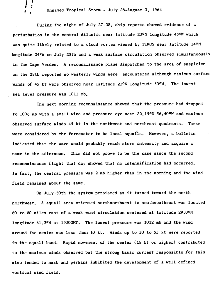
Television Infrared Observation Satellite (TIROS) indicated an area of disturbed weather with a weak surface circulation in the vicinity of Cape Verde on July 25.[11] Reports from a reconnaissance aircraft indicate that a tropical depression developed at 06:00 UTC on July 28, while located about halfway between the Leeward Islands and the northernmost islands of Cape Verde.[11][3] Initially the depression moved rapidly west-northwestward, which likely caused the minimal intensification. By July 30, a north-northwest to south-southeast oriented trough forced the depression to re-curve north-northwestward.[11]
While situated about 300 mi (480 km) east of Bermuda on July 31, it began heading northeastward. Later that day, the depression finally organized further and developed a well-defined rainband. The Atlantic hurricane database indicates that the depression strengthened into a tropical storm at 18:00 UTC on July 31, due to ships reports of winds reaching 46 mph (74 km/h).[11][3] On August 1, it intensified further into a hurricane. Around that time, maximum sustained winds peaked at 85 mph (137 km/h).[3] The storm continued moving rapidly northeastward and began to interact with a cold front.[11] It transitioned into an extratropical cyclone on August 2, while located about 525 mi (845 km) east of Cape Race, Newfoundland.[3]
Tropical Storm Abby
| Tropical storm (SSHWS) | |
  | |
| Duration | August 5 – August 8 |
|---|---|
| Peak intensity | 70 mph (110 km/h) (1-min) 1000 mbar (hPa) |
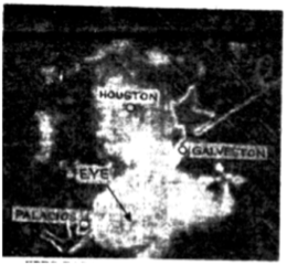
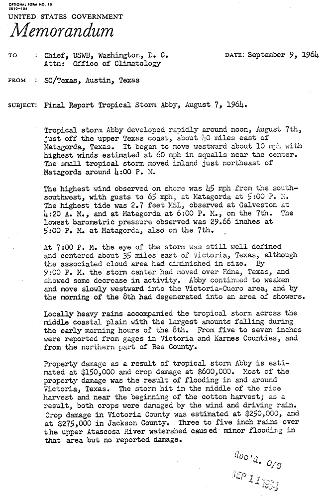
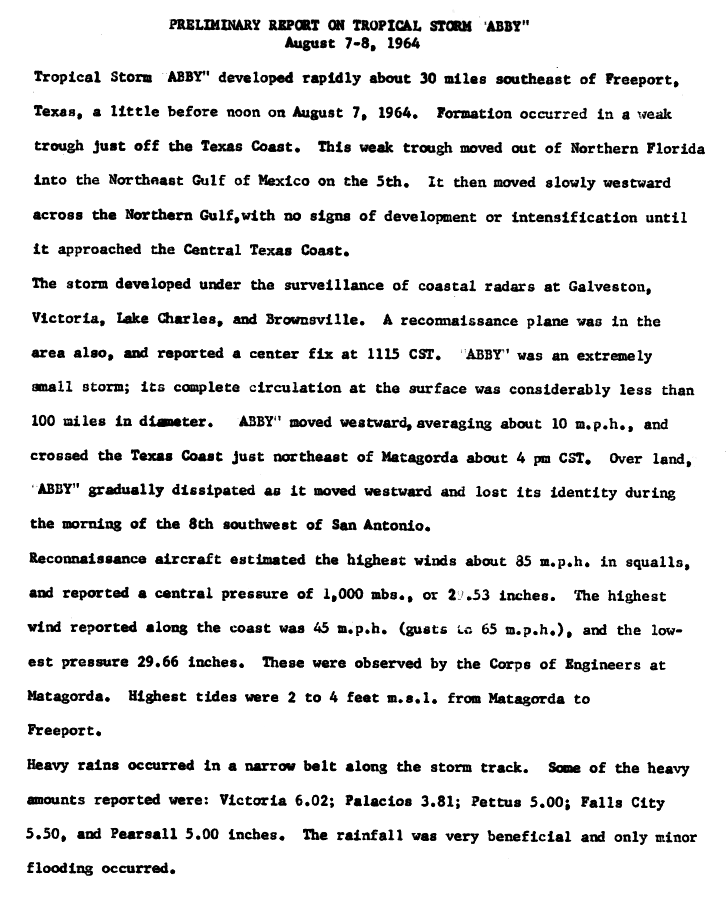
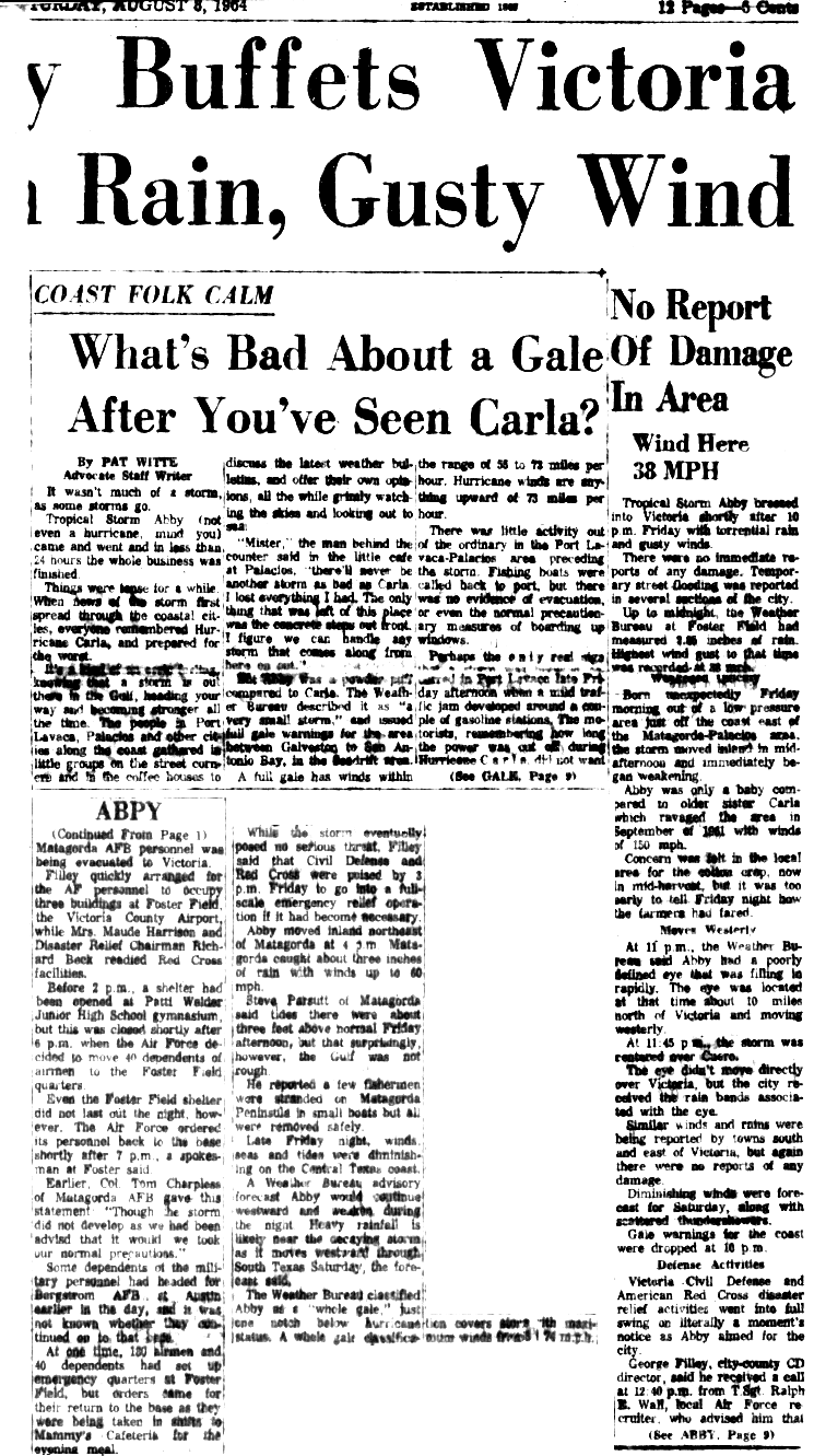
A weak trough developed into a tropical depression on August 5 while located about 225 mi (362 km) south of Dauphin Island, Alabama.[12][3] The depression moved westward and initially remained disorganized.[12][3] At 12:00 UTC on August 7, the depression strengthened into Tropical Storm Abby.[3] It was a small tropical cyclone, spanning a diameter of less than 100 mi (160 km).[12] The storm quickly intensified furtherlate on August 7. A few hours later, Abby made landfall near Matagorda, Texas at just below hurricane intensity (although it is possible it may have reached that intensity, the lack of definitive observations prevented an upgrade). It weakened to a tropical depression early on August 8, before dissipating later that day.[3]
Overall, impact from this system was minor. In Texas, precipitation peaked at 6.14 in (156 mm) at the Victoria Regional Airport.[13] However, only localized flooding occurred and rainfall was mostly beneficial. In the city of Victoria, several streets were temporarily inundated with water.[14] A fishing company in Matagorda lost a portion of its roof.[15] Abby resulted in an estimated $750,000 in losses, with $150,000 in damage to property and $600,000 to crops. The impacts from the storm were most severe in Jackson and Victoria counties, where damage to crops were estimated at $275,000 and $250,000, respectively.[16]
Tropical Storm Brenda
| Tropical storm (SSHWS) | |
 | |
| Duration | August 8 – August 10 |
|---|---|
| Peak intensity | 50 mph (85 km/h) (1-min) 1006 mbar (hPa) |
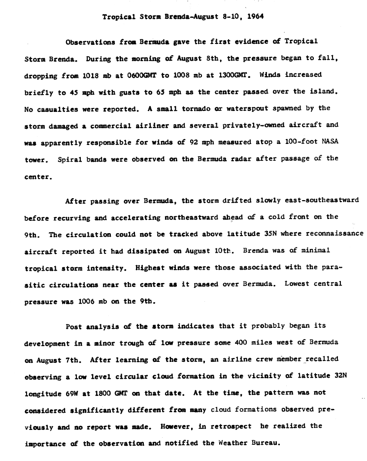
A minor trough of low pressure was situated west of Bermuda in early August. An airline crew member observed a low-level circular cloud forming at 32.0°N, 69.0°W at 18:00 UTC on August 7.[17] Afterward, a tropical depression developed about 245 mi (394 km) west of Bermuda. It moved just north of due east and strengthened into Tropical Storm Brenda on August 8. Shortly thereafter, the storm struck Bermuda.[3] Sustained winds on the island reached 45 mph (72 km/h), while gusts up to 65 mph (105 km/h) were reported. A tornado damaged several aircraft, most of which were privately owned.[17] Losses reached approximately $275,000.[8]
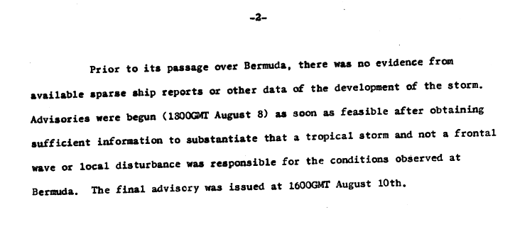
Shortly after moving across Bermuda on August 8, spiral bands appeared on the island's radar.[17] Advisories on Brenda were not initiated until 18:00 UTC on August 8, due to sparsity of data, making it difficult to confirm a tropical cyclone.[18] A cold front caused the storm to re-curve northeastward on August 9.[17] Later that day, Brenda attained its peak intensity with maximum sustained winds of 50 mph (80 km/h) and a minimum barometric pressure of 1,006 mbar (29.7 inHg).[3] Brenda then began weakening and dissipated late on the following day, while located about 585 mi (941 km) east-northeast of Bermuda.[3][18]
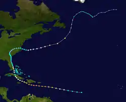
Hurricane Cleo
| Category 4 hurricane (SSHWS) | |
  | |
| Duration | August 20 – September 5 |
|---|---|
| Peak intensity | 150 mph (240 km/h) (1-min) 938 mbar (hPa) |
A tropical wave developed into a tropical depression while located about 890 mi (1,430 km) east of Barbados late on August 20. Early the following day, the depression strengthened into Tropical Storm Cleo. It continued west-northwestward, quickly intensifying into a hurricane later on August 21. Cleo rapidly deepened and reached Category 3 early on August 22. Several hours later, Cleo struck Guadeloupe with winds of 115 mph (185 km/h). The storm then intensified into a Category 4 hurricane and entered the Caribbean Sea. While located south of the Dominican Republic around 18:00 UTC on August 23, Cleo attained its peak intensity with winds of 155 mph (249 km/h).[3] Cleo weakened slightly before making landfall near Les Cayes, Haiti, on August 25, with winds of 150 mph (240 km/h).[8] The storm re-emerged into the Caribbean hours later, but rapidly weakened, falling to Category 3 hurricane at 12:00 UTC and to Category 1 hurricane only six hours later. Around 12:00 UTC on August 25, the hurricane briefly moved ashore near Cape Cruz, Cuba, while winds were at 80 mph (130 km/h).[3]
Cleo emerged into the Gulf of Guacanayabo, before striking Sancti Spíritus Province as a minimal hurricane early on August 26. Several hours later, the hurricane emerged into the Atlantic Ocean and began re-strengthening while moving northward, becoming a Category 2 hurricane early the next day.[3] Around 06:00 UTC on August 27, Cleo made landfall on Key Biscayne, Florida,[8] with winds of 110 mph (180 km/h). The system quickly weakened inland, falling to tropical storm intensity early the following day, but did not deteriorate to a tropical depression until August 29. Thereafter, the cyclone meandered slowly across The Carolinas and Virginia, but did not dissipate. Cleo instead re-intensified into a tropical storm while re-entering the Atlantic near Norfolk, Virginia, on September 1. It moved east-northeastward and became a hurricane again about 24 hours later. By early on September 4, the cyclone accelerated and curved north-northeastward. Cleo weakened to a tropical storm on September 5 and became extratropical soon after while located about 370 mi (600 km) east-northeast of Cartwright, Newfoundland and Labrador.[3]
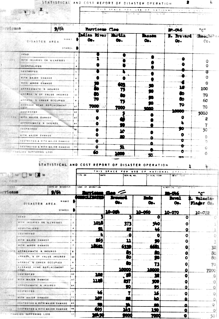
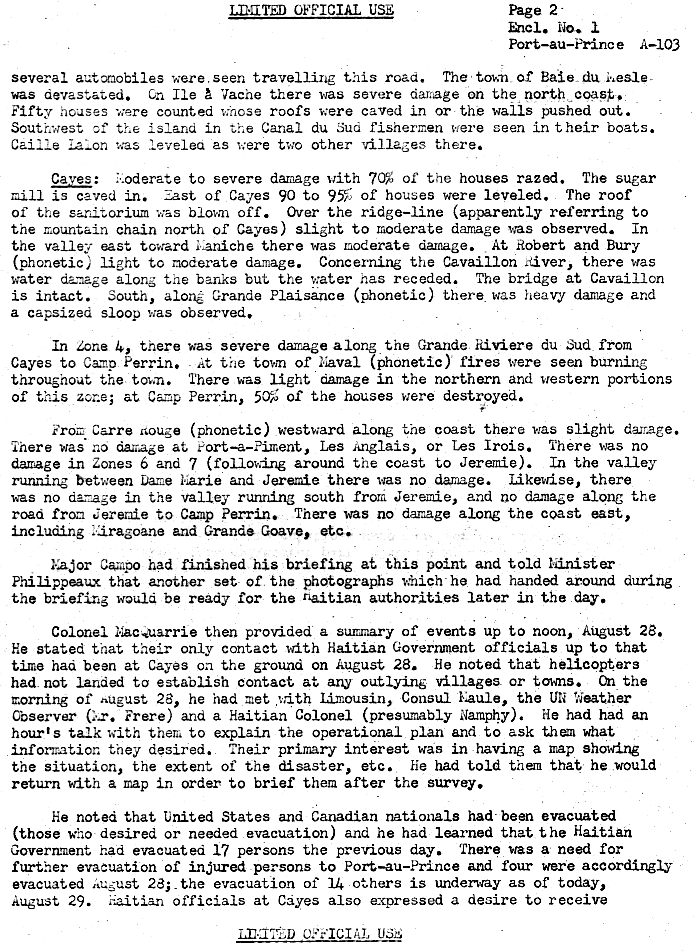
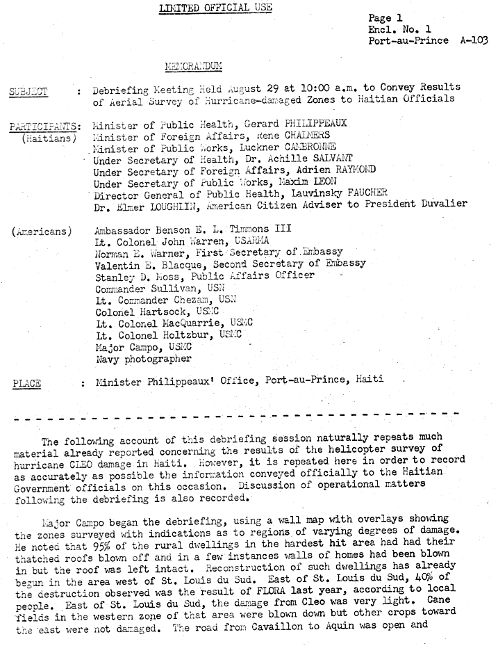
In Guadeloupe, the storm destroyed 1,000 homes and caused extensive damage to roofs, roads, and power lines. Additionally, the banana crop was ruined. Overall, there were 14 deaths and about $50 million in damage.[19] Cleo caused seven fatalities and at least $2 million in damage in Dominican Republic.[8] Strong winds in Haiti caused severe damage. On Île-à-Vache, 50 houses either had the roof caved in or the walls knocked over. In Les Cayes, 70% of houses were destroyed, as was the sugar mill. In rural areas outside of the city, 90% to 95% of dwellings were demolished.[20] About half of the houses in Camp-Perrin were leveled. Near Saint-Louis-du-Sud, many sugarcane crops, particularly on the west side of the city, were ruined.[21] The storm left 192 fatalities and $5 million in damage in Haiti. Impact in Cuba was minor, with one death and $2 million in damage.[8] In Florida, Cleo left damage along much of the east coast. Winds left about 620,000 people without electricity in South Florida alone.[22] Throughout the state, the storm damaged almost 19,000 homes and destroyed 4 others, while 2,187 mobile homes were flattened or suffered severe impact. Additionally, 605 small businesses were damaged or destroyed. There were three deaths and about $125 million in damage, including agriculture.[23] Cleo brought flooding to a few other states, especially Virginia. In the Hampton Roads area, many streets were inundated and blocked. Hundreds of dwellings were flooded, forcing several areas to evacuate.[8] Two deaths and about $3 million in damage occurred in Virginia. Overall, the storm caused 219 fatalities and about $187.5 million in damage.[8][19][23]
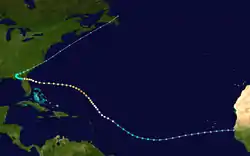
Hurricane Dora
| Category 4 hurricane (SSHWS) | |
  | |
| Duration | August 28 – September 13 |
|---|---|
| Peak intensity | 130 mph (215 km/h) (1-min) 942 mbar (hPa) |
A tropical depression developed from a low pressure on August 28, shortly after moving offshore the west coast of Africa near Dakar, Senegal. The depression was upgraded to Tropical Storm Dora on September 1.[8] It then curved northeastward and continued to strengthen, reaching hurricane status by early on September 3. Intensification slowed somewhat, though Dora became a Category 3 major hurricane on September 5. Deepening further, the peaked as a Category 4 with maximum sustained winds of 130 mph (210 km/h) and a minimum barometric pressure of 942 mbar (27.8 inHg) early the following day. At 18:00 UTC on September 16, Dora weakened to a Category 3 hurricane, then a Category 2 hurricane while curving westward early the following day. However, later on September 17, the system re-strengthened into a Category 3 hurricane.[3]
Approaching the east coast of Florida, Dora's motion became erratic, making a few cyclonic loops. Around 04:00 UTC on September 10,[24] the hurricane made landfall near St. Augustine, Florida, with winds of 115 mph (185 km/h). Two hours later, Dora weakened to a Category 2 hurricane. However, deterioration then slowed, with the hurricane falling to tropical storm intensity on September 11. Dora then briefly drifted over southwestern Georgia, until turned east-northeastward late the next day. Early on September 14, the storm re-emerged into the Atlantic Ocean near Cape Hatteras, North Carolina, and became extratropical several hours later. The remnants of Dora moved rapidly northeastward and dissipated offshore Newfoundland early on September 16.[3]
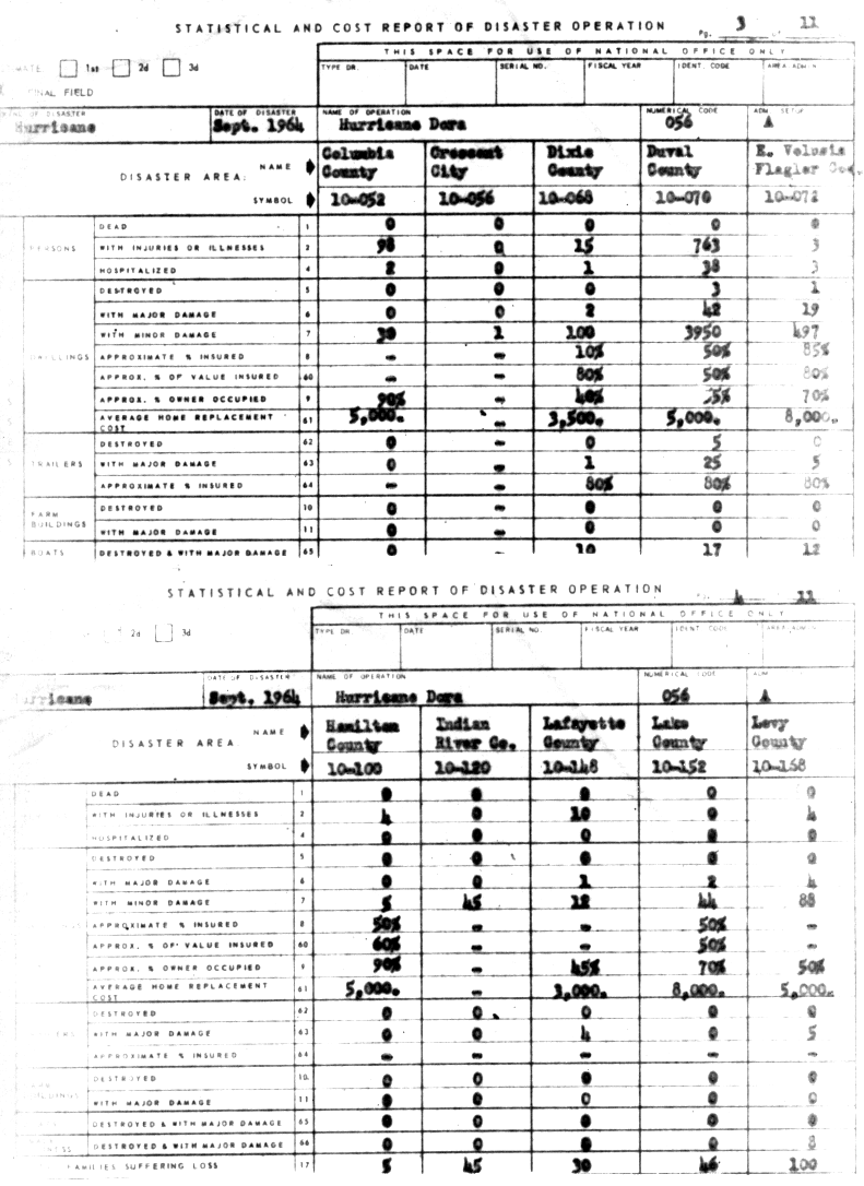
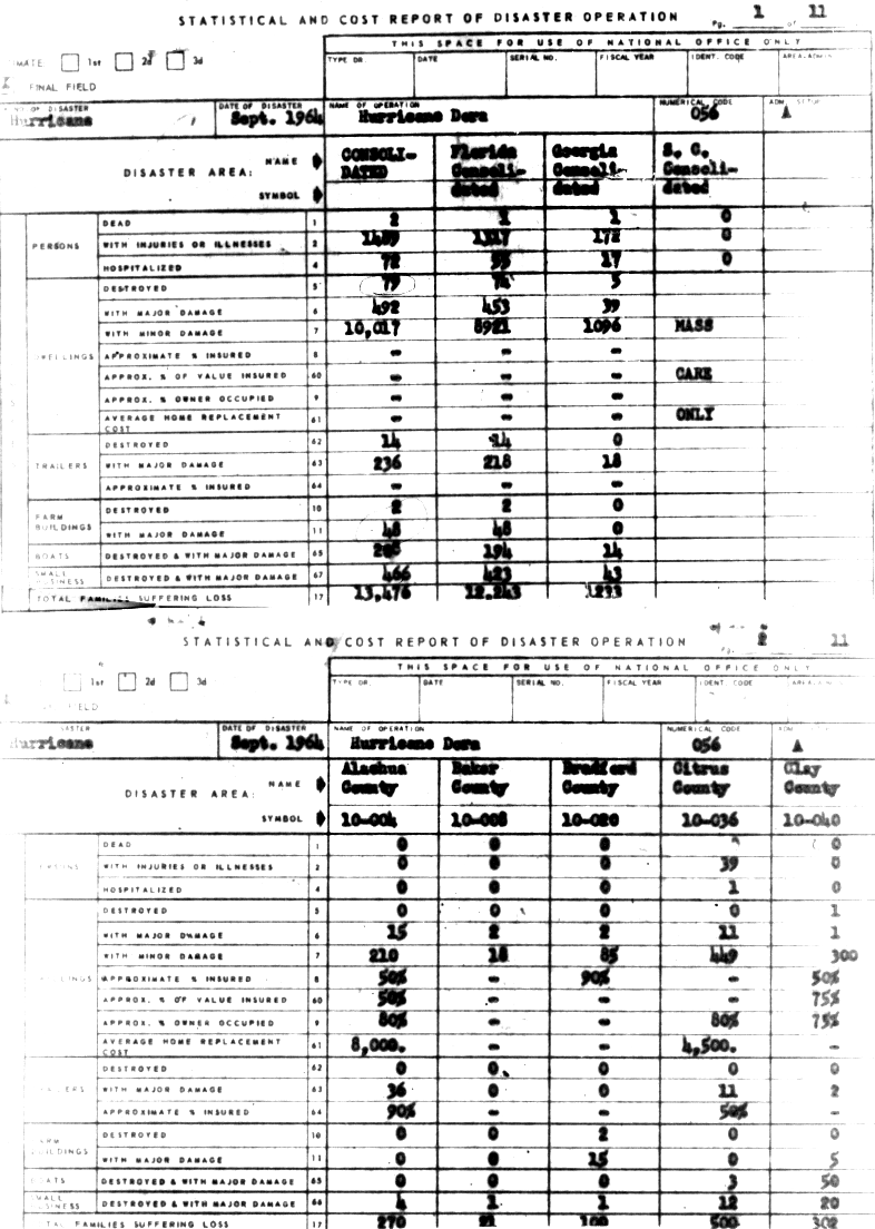
Hurricane Dora was the only hurricane in the twentieth century to make landfall in the First Coast region of Florida. Along the coast, tides reached up to 10 ft (3.0 m) above mean sea level.[8] Strong winds lashed North Florida, with sustained wind of 125 mph (201 km/h) observed in St. Augustine.[8] In Jacksonville, approximately 156,000 customers were left without electricity, while about 19% of phones in Duval County were out of service.[25] Much of the damage in the Jacksonville area occurred to older buildings and those located in coastal areas. Additionally, sections of the city experienced wind-induced river flooding in the vicinity of the St. Johns River.[8] Three homes were destroyed and 3,992 suffered damage, while 5 mobile homes were demolished and 25 experienced impact, overall in Duval County.[26] Heavy rainfall damaged many unharvested crops and inundated numerous of roads and bridges, isolated some communities for several days.[8] Throughout Florida, 74 dwellings were flattened and 9,374 received damage, while 14 mobile homes were destroyed and 218 others suffered severe impact. About 50 farm buildings and 423 small businesses were severely damaged or demolished.[27] Three deaths and at least $230 million in damage occurred.[8] In Georgia, the storm damaged about 1,135 homes and obliterated five others. Additionally, 18 trailers suffered major impact, while 43 small businesses were destroyed or experienced severe damage.[27] There was one death in the state and at least $9 million in damage. A few other states were affected by the storm, though impact there was much lesser. One death occurred in Virginia. Overall, Dora caused $280 million in damage and five deaths.[8]
Hurricane Ethel
| Category 2 hurricane (SSHWS) | |
  | |
| Duration | September 4 – September 14 |
|---|---|
| Peak intensity | 105 mph (165 km/h) (1-min) 974 mbar (hPa) |
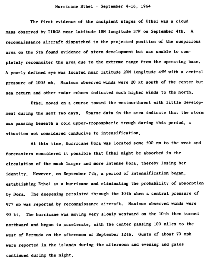
TIROS observed a large cloud mass near 18°N, 37°W on September 4.[28] Later that day, it developed into a tropical depression while located about 665 mi (1,070 km) east of Cape Verde. The depression moved west-northwestward and intensified into Tropical Storm Ethel at 12:00 UTC on September 4.[3] Initially, it was suggested that Hurricane Dora could absorb Ethel, as the storms were located 690 mi (1,110 km) apart.[28] On September 7, Ethel strengthened into a hurricane. By early on the following day, it curved westward and continued to slowly deepen. Late on September 9, the storm peaked as a Category 2 hurricane with maximum sustained winds of 105 mph (169 km/h).[3]
Thereafter, the storm weakened back to a Category 2 hurricane early on September 10. It further deteriorated to a Category 1 on the following day. Early on September 12, Ethel re-strengthened to a Category 2 hurricane. Later that day, the storm passed to the northwest of Bermuda on September 12,[3] bringing 4.05 in (103 mm) of and wind gusts up to 70 mph (110 km/h).[28][29] Throughout the island, low-lying areas were flooded and trees were felled. At St. George's Island, residents were briefly left without electricity and telephones and the causeway linking St. George's Island to the main island was inundated.[30] Next, it resumed weakened and was downgraded to a Category 1 late on September 13. Ethel accelerated northeastward and became extratropical late on September 15, while located about 540 mi (870 km) northwest of Corvo Island in the Azores.[3]
Tropical Storm Florence
| Tropical storm (SSHWS) | |
 | |
| Duration | September 5 – September 10 |
|---|---|
| Peak intensity | 45 mph (75 km/h) (1-min) 1002 mbar (hPa) |
A tropical wave emerged into the Atlantic Ocean from the west coast of Africa on September 5.[8] The wave quickly developed into a tropical depression at 1800 UTC on September 5, while located about 180 mi (290 km) northwest of Dakar, Senegal.[3] Shortly later, the depression produced squally weather in Cape Verde.[8] Despite having sustained winds of only 25 mph (40 km/h),[3] the system's minimum barometric pressure of 1,002 mbar (29.6 inHg) was recorded early on September 6.[8] The depression then re-curved northwestward and began to intensify. Early on September 8, it was upgraded to Tropical Storm Florence. Six hours later, the storm attained its maximum sustained wind speed of 45 mph (72 km/h). Florence curved north-northeastward on September 8 and slowly weakened.[3] A reconnaissance aircraft reported that Florence degenerated into an area of squalls to the south of the Azores at 0600 UTC on September 10.[8][3]
Hurricane Gladys
| Category 4 hurricane (SSHWS) | |
  | |
| Duration | September 13 – September 24 |
|---|---|
| Peak intensity | 130 mph (215 km/h) (1-min) 945 mbar (hPa) |
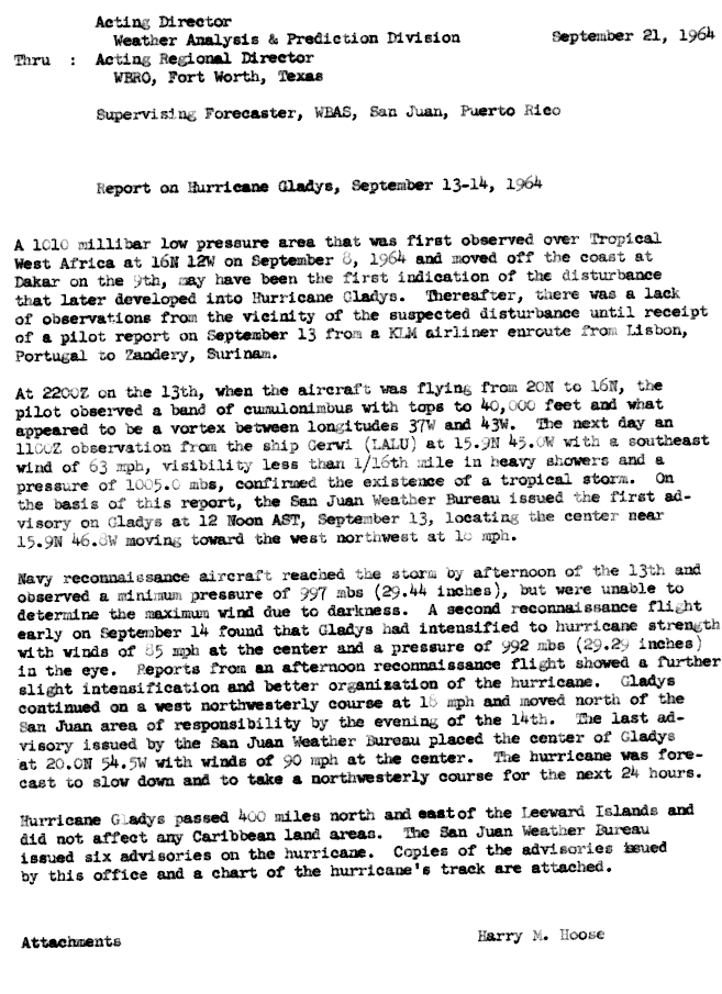
A emerged into the Atlantic from the west coast of Africa on September 8.[31] Tracking westward, it developed into a tropical depression while centered about midway between the Lesser Antilles and Cape Verde on September 13. Shortly thereafter, it strengthened Tropical Storm Gladys. On September 14, Gladys abruptly strengthened into a Category 2 hurricane, with winds increasing from 70 to 100 mph (110 to 160 km/h) in just six hours. However, early on the following day, Gladys weakened slightly to a Category 1 hurricane. Between late on September 16 and late on September 17, the storm rapidly intensified and peaked as a 130 mph (210 km/h) Category 4 hurricane later that day. Gladys began weakening on the following day and re-curved northward on September 19.[3]
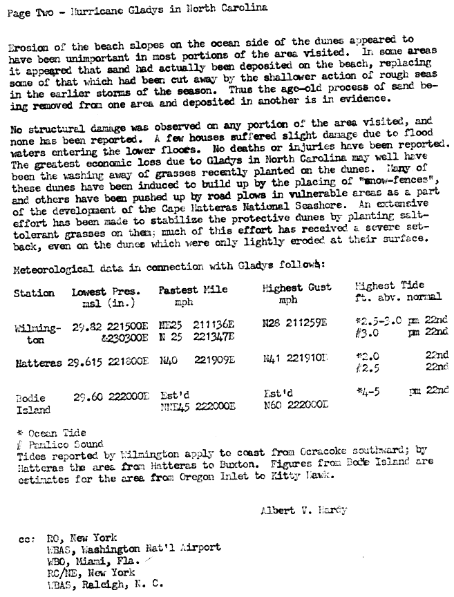
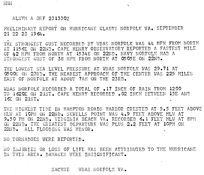
The storm turned northwestward on September 22 and briefly threatened the East Coast of the United States. However, it veered northeastward on September 23 and moved rapidly toward Atlantic Canada. By 00:00 UTC on September 25, Gladys became extratropical while centered between Sable Island and the Nova Scotia mainland.[3] Along the East Coast of the United States, Gladys produced light rainfall, gusty winds, and storm surge. Coastal flooding was reported in North Carolina and Virginia.[32][33] In the former, high tides inundated homes and buildings with 2 ft (0.61 m) of water in two small villages on the Outer Banks and flooded a highway to Manteo.[32][34] In the state of Virginia, one death occurred when a man was fatally struck in the throat by debris.[35] Abnormally high tides also affected the Mid-Atlantic, New England,[36][37] and Atlantic Canada,[38] with tides ranging from 2.2–6.1 ft (0.67–1.86 m) higher than average in Virginia.[33]
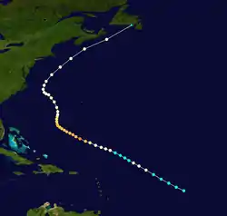
Hurricane Hilda
| Category 4 hurricane (SSHWS) | |
  | |
| Duration | September 28 – October 4 |
|---|---|
| Peak intensity | 140 mph (220 km/h) (1-min) 941 mbar (hPa) |
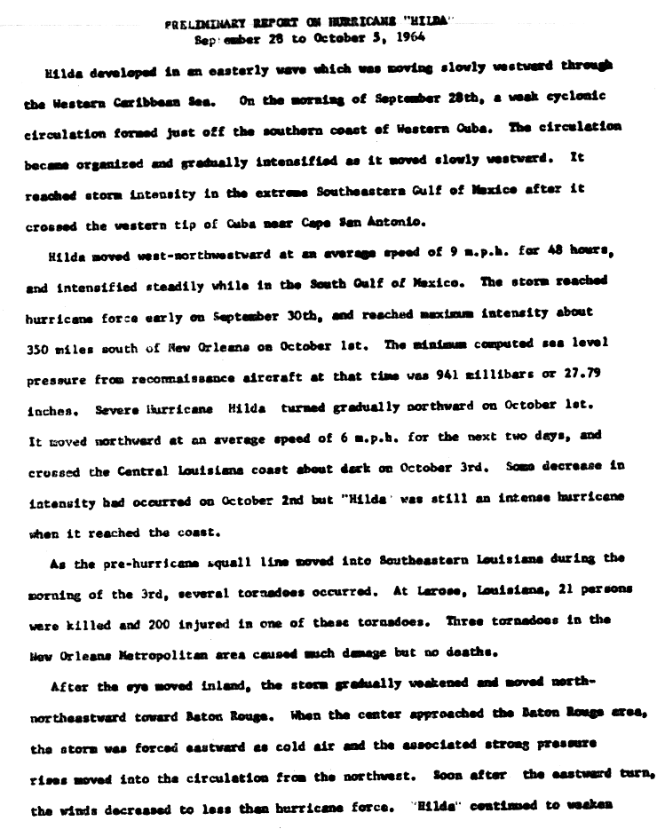
A tropical wave developed into a tropical depression at 12:00 UTC on September 28, while located about 40 mi (64 km) south of Trinidad, Cuba.[39][3] The depression tracked west-northwestward and struck Isla de la Juventud, Cuba early on September 29. After briefly re-emerging into the northwestern Caribbean Sea later that day, the depression strengthened into Tropical Storm Hilda at 1200 UTC on September 29. Around that time, Hilda made landfall near Sandino, Cuba with winds of 40 mph (64 km/h). By late on September 29, it emerged into the Gulf of Mexico near Cape San Antonio. The storm continued to intensify, reaching hurricane status on September 30. During the following 30 hours, Hilda strengthened significantly and peaked as a Category 4 hurricane with winds of 140 mph (230 km/h) late on October 1. It re-curved northward and began weakening due to unfavorable conditions. Around 00:00 UTC on October 4, the storm made landfall near Franklin, Louisiana with winds of 105 mph (169 km/h). It rapidly weakened inland and became extratropical over southern Mississippi by 1200 UTC that day.[3]
In Cuba, the storm caused minor impact, with damage totaling about $1 million.[8] Offshore the United States in the Gulf of Mexico, 13 oil platforms were destroyed and 5 others were damaged beyond repair. Losses to the oil industry reached $100 million.[40] In Louisiana, sustained winds of 90 to 105 mph to (150 to 165 km/h) lashed the Abbeville-Morgan City-New Iberia area. Additionally, several tornadoes in the New Orleans area resulted in significant damage. There were 37 fatalities and an estimated 5,000 injuries. Approximately 19,000 homes were damaged in the state, 2,600 of which were severely impacted. Outside of Louisiana, damage was primarily caused by flooding in the Southeastern United States. Impacted worst by flooding was North Carolina, where 2000 homes and buildings suffered water damage and one death was reported.[41] Throughout the United States, the storm caused 38 fatalities and $125 million in losses.[8]
Hurricane Isbell
| Category 3 hurricane (SSHWS) | |
  | |
| Duration | October 8 – October 16 |
|---|---|
| Peak intensity | 115 mph (185 km/h) (1-min) 964 mbar (hPa) |
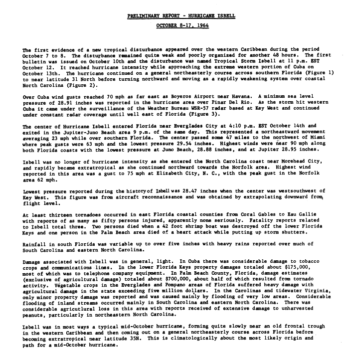
A diffused frontal trough developed into a tropical depression in the southwestern Caribbean on October 8.[8] The depression initially remained disorganized as it track northwestward, but strengthened into Tropical Storm Isbell on October 13. Re-curving northeastward, Isbell quickly strengthened further and reached hurricane status by later that day. Late on October 13, Isbell made landfall in the Pinar del Río Province of Cuba. Despite land interaction, the storm continued strengthening and peaked as a Category 3 hurricane winds of 125 mph (201 km/h) on the following day. Isbell moved northeastward and made landfall near Everglades, Florida, at the same intensity late on October 14. After reaching the Atlantic on the following day, the storm began to weaken and fell Category 1 hurricane. Isbell turned northward and continued weakening, before transitioning to an extratropical cyclone while located just offshore of eastern North Carolina on October 16.[3]
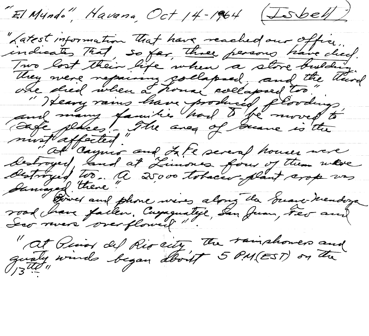
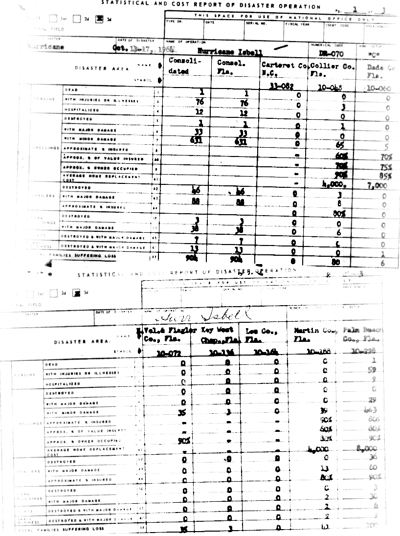
The storm produced strong winds throughout western Cuba. Hundreds of homes were destroyed, as were several tobacco warehouses. There were four deaths in Cuba,[42][43] three of them caused by collapsing houses in the Guane area.[43] Several tornadoes in Florida caused significant damage overall.[44] Throughout the state, 1 house was destroyed, 33 severely damage, and 631 suffered minor impact. Additionally, 66 trailers were destroyed and 88 were inflicted with major damage.[45] Three deaths occurred in the state, one due to a heart attack and two from drowning in Florida Keys when their shrimp boat sank.[44] Because the storm weakened considerably, impact in North Carolina was generally minor. The storm also spawned at least six tornadoes in the state, which demolished trailers and unroofed homes and other buildings in several communities.[42] Damage throughout the United States totaled $10 million.[8]
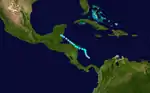
Tropical Storm Thirteen
| Tropical storm (SSHWS) | |
 | |
| Duration | November 5 – November 10 |
|---|---|
| Peak intensity | 70 mph (110 km/h) (1-min) 997 mbar (hPa) |
An area of disturbed weather within the ITCZ developed into a tropical depression early on November 5, while located about 135 mi (217 km) north-northwest of Colón, Panama.[8][3] The depression strengthened slowly, reaching tropical storm status on November 6. Thereafter, it curved westward and headed for Central America, beginning a rapid strengthening trend. Early on November 7, the storm made landfall near Puerto Cabezas, Nicaragua, with winds of 70 mph (110 km/h). Several hours later, it weakened to a tropical depression, shortly before re-emerging into the Caribbean Sea. The storm failed to re-intensify and made landfall in Belize on November 9. It dissipated early on the following day.[3]
In Nicaragua, winds and heavy rainfall caused significant crop damage, especially to bananas. Many residents living near the Caratasca Lagoon evacuated. The entire town of Caukira was flooded, with five small houses completely destroyed. Tides were as high as 18 ft (5.5 m) above-normal. In Puerto Castilla, large amounts of precipitation caused flooding and destroyed a bridge, leaving part of the population out of communication. Another bridge collapsed in the town of Rus-Rus. Strong winds and heavy rainfall also resulted in "considerable damage" on the Bay Islands. Overall, the storm resulted in about $5 million in damage.[8]
Other systems
In addition to the thirteen tropical storms, there were two depressions monitored throughout the season. TIROS VII depicted two tropical depressions, one on July 15 and the other on September 19 at 20°N 25°W and 15°N 27°W, respectively. Due to the sparsity of data in the region and lack of complete satellite coverage, no further information on these systems is available.[46]
Storm names
The following names were used for named storms that formed in the North Atlantic in 1964. This is the same list used in the 1960 season with the exception of Dora, which replaced Donna.[47] A storm was named Isbell for the first time in 1964. The names Cleo, Dora, and Hilda were later retired and replaced with Candy, Dolly, and Hannah, respectively, in the 1968 season.[48][49] Names that were not assigned are marked in gray.
|
Season effects
The following table lists all of the storms that have formed in the 1964 Atlantic hurricane season. It includes their duration, names, landfall(s) (in parentheses), damages, and death totals. Deaths in parentheses are additional and indirect (an example of an indirect death would be a traffic accident), but were still related to that storm. Damage and deaths include totals while the storm was extratropical, a wave, or a low, and all of the damage figures are in 1964 USD.
| Saffir–Simpson scale | ||||||
| TD | TS | C1 | C2 | C3 | C4 | C5 |
| Storm name |
Dates active | Storm category
at peak intensity |
Max 1-min wind mph (km/h) |
Min. press. (mbar) |
Areas affected | Damage (USD) |
Deaths | Refs | ||
|---|---|---|---|---|---|---|---|---|---|---|
| One | June 2 – 11 | Tropical storm | 70 (110) | 989 | Yucatán Peninsula, Cuba, Southeastern United States | $1 million | None | |||
| Two | July 23 – 26 | Tropical storm | 60 (95) | 1001 | East Coast of the United States, Atlantic Canada | Unknown | None | |||
| Three | July 28 – August 2 | Category 1 hurricane | 85 (140) | 990 | British Isles | None | None | |||
| Abby | August 5 – 8 | Tropical storm | 65 (100) | 1000 | United States Gulf Coast | $750,000 | None | |||
| Brenda | August 8 – 10 | Tropical storm | 50 (85) | 1006 | Bermuda | $275,000 | None | |||
| Cleo | August 20 – September 5 | Category 4 hurricane | 150 (240) | 938 | Lesser Antilles, Greater Antilles, The Bahamas, Southeastern United States, Newfoundland | $187.5 million | 219 | |||
| Dora | August 28 – September 13 | Category 4 hurricane | 130 (215) | 942 | Bahamas, East Coast of the United States, Atlantic Canada | $280 million | 5 | |||
| Ethel | September 4 – 14 | Category 2 hurricane | 105 (165) | 974 | Bermuda | Minimal | None | |||
| Florence | September 5 – 10 | Tropical storm | 45 (75) | 1002 | West Africa, Cape Verde | None | None | |||
| Gladys | September 13 – 24 | Category 4 hurricane | 130 (215) | 945 | East Coast of the United States, Atlantic Canada | $100,000 | 1 | |||
| Hilda | September 28 – October 4 | Category 4 hurricane | 140 (220) | 941 | Cuba, Yucatán Peninsula. East Coast of the United States, United States Gulf Coast | $125 million | 38 | |||
| Isbell | October 8 – 16 | Category 3 hurricane | 115 (185) | 964 | Cuba, East Coast of the United States | $30 million | 7 | |||
| Thirteen | November 5 – 10 | Tropical storm | 70 (110) | 997 | Central America | $5 million | None | |||
| Season aggregates | ||||||||||
| 17 systems | June 2 – November 10 | 150 (240) | 938 | ~$629.63 million | 270 | |||||
See also
- 1964 Pacific hurricane season
- 1964 Pacific typhoon season
- 1964 North Indian Ocean cyclone season
- List of Atlantic hurricanes
- Atlantic hurricane season
Notes
- All damage figures are in 1966 USD, unless otherwise noted
References
- Atlantic basin Comparison of Original and Revised HURDAT. Hurricane Research Division; Atlantic Oceanographic and Meteorological Laboratory (Report). National Oceanic and Atmospheric Administration. March 2015. Retrieved September 2, 2015.
- "Hurricane Watch Starts Today; Season Officially Open June 15". The Palm Beach Post. United Press International. June 1, 1964. p. 24. Retrieved September 2, 2015.
- "Atlantic hurricane best track (HURDAT version 2)" (Database). United States National Hurricane Center. May 25, 2020.
- Philip J. Klotzbach; William M. Gray (December 8, 2006). Extended Range Forecast of Atlantic Seasonal Hurricane Activity and U.S. Landfall Strike Probability for 2007 (Report). Colorado State University. Archived from the original on December 18, 2006. Retrieved September 2, 2015.
- "Odds In Favor Of Hurricanes". Star-News. June 20, 1964. p. 8. Retrieved September 2, 2015.
- Gordon E. Dunn (March 1965). The Hurricane Season of 1964 (PDF). United States Weather Bureau (Report). Atlantic Oceanographic and Meteorological Laboratory; National Oceanic and Atmospheric Administration. Retrieved June 11, 2013.
- Final Report Tropical Storm Abby, August 7, 1964. United States Weather Bureau (Report). National Hurricane Center; National Oceanic and Atmospheric Administration. September 9, 1964. Retrieved June 11, 2013.
- Hurricane Cleo August 20 – September 4, 1964 (PDF). United States Weather Bureau (Report). National Oceanic and Atmospheric Administration. 1964. Archived from the original (PDF) on October 31, 2011. Retrieved June 9, 2014.
- Hurricane Cleo: 9/64 (DR-046). United States Weather Bureau (Report). National Hurricane Center; National Oceanic and Atmospheric Administration. Retrieved September 2, 2015.
- "East Coast Sparred as Hurricane Veers". Oshkosh Daily Northwestern. Associated Press. 1964.
- ""El Mundo", Havana, October 14, 1964 (Isbell)". National Hurricane Center; National Oceanic and Atmospheric Administration. October 14, 1964.
- David Levinson (August 20, 2008). 2005 Atlantic Ocean Tropical Cyclones. National Climatic Data Center (Report). National Oceanic and Atmospheric Administration. Archived from the original on December 1, 2005. Retrieved March 6, 2012.
- Gordon E. Dunn (March 1965). The Hurricane Season of 1964 (PDF). United States Weather Bureau (Report). Atlantic Oceanographic and Meteorological Laboratory; National Oceanic and Atmospheric Administration. Retrieved June 11, 2013.
- "Carolinas Get Soaking". Chicago Tribune. June 8, 1964. p. 16. Retrieved September 2, 2015.
- United States Weather Bureau (September 1964). "Rough Log, North Atlantic Weather". Mariners Weather Log. 8 (5): 170.
- Unnamed Tropical Storm – July 28–August 3, 1964. United States Weather Bureau (Report). National Hurricane Center; National Oceanic and Atmospheric Administration. 1964. p. 1. Retrieved June 10, 2013.
- Preliminary Report On Tropical Storm "Abby". United States Weather Bureau (Report). National Hurricane Center; National Oceanic and Atmospheric Administration. 1964. p. 1. Retrieved June 11, 2013.
- Roth, David M. (October 18, 2017). "Tropical Cyclone Point Maxima". Tropical Cyclone Rainfall Data. United States Weather Prediction Center. Retrieved November 26, 2017.
- "No Report Of Damage In Area". The Victoria Advocate. National Hurricane Center; National Oceanic and Atmospheric Administration. August 8, 1964. Retrieved June 11, 2013.
- "Abby Fizzles Out". Galveston Tribune. August 10, 1964. Retrieved June 11, 2013.
- Final Report Tropical Storm Abby, August 7, 1964. United States Weather Bureau (Report). National Hurricane Center; National Oceanic and Atmospheric Administration. September 9, 1964. Retrieved June 11, 2013.
- Tropical Storm Brenda – August 4–10, 1964. United States Weather Bureau (Report). National Hurricane Center; National Oceanic and Atmospheric Administration. 1964. p. 1. Retrieved June 10, 2013.
- Tropical Storm Brenda – August 4–10, 1964. United States Weather Bureau (Report). National Hurricane Center; National Oceanic and Atmospheric Administration. 1964. p. 2. Retrieved June 10, 2013.
- Hurricane Cleo August 20 – September 4, 1964 (PDF). United States Weather Bureau (Report). National Oceanic and Atmospheric Administration. 1964. Archived from the original (PDF) on October 31, 2011. Retrieved June 9, 2014.
- Norman E. Warner (September 9, 1964). Hurricane Cleo: Memorandum of Debriefing Session Held for Purpose of Informing Haitian Officials of Results of Aerial Survey of Damage (Report). Port-au-Prince, Haiti: United States Department of State. p. 3. Retrieved September 2, 2015.
- Norman E. Warner (September 9, 1964). Hurricane Cleo: Memorandum of Debriefing Session Held for Purpose of Informing Haitian Officials of Results of Aerial Survey of Damage (Report). Port-au-Prince, Haiti: United States Department of State. p. 2. Retrieved September 2, 2015.
- "1964 – Hurricane Cleo". Sun-Sentinel. Retrieved September 2, 2015.
- Hurricane Cleo: 9/64 (DR-046). United States Weather Bureau (Report). National Hurricane Center; National Oceanic and Atmospheric Administration. Retrieved September 2, 2015.
- George Cry (1964). Hurricane Dora, August 28 – September 16, 1964 (PDF). United States Weather Bureau (Report). Silver Spring, Maryland: National Oceanic and Atmospheric Administration. Retrieved 20 July 2014.
- Emergency Preparedness Guide Duval County Emergency Management 2014–2015 (PDF) (Report). Jacksonville, Florida: Duval County Emergency Management. 2014. Archived from the original (PDF) on July 18, 2014. Retrieved July 20, 2014.
- Hurricane Dora Florida Damage Summary (Report). National Oceanic and Atmospheric Administration. 1964. p. 3. Retrieved September 1, 2015.
- Hurricane Dora Florida Damage Summary (Report). National Oceanic and Atmospheric Administration. 1964. p. 1. Retrieved September 1, 2015.
- Hurricane Ethel, September 4–6, 1964. United States Weather Bureau (Report). National Hurricane Center; National Oceanic and Atmospheric Administration. 1964. p. 2. Retrieved June 14, 2013.
- Mark Guishard; James Dodgson; Michael Johnston (May 2015). Hurricanes – General Information for Bermuda (Report). Hamilton, Bermuda: Bermuda Weather Service. Archived from the original on November 17, 2015. Retrieved November 13, 2015.
- "Dora Dumps Heavy Rains on Carolinas". Cumberland Times-News. Wilmington, North Carolina. Associated Press. September 19, 1964. p. 1. Retrieved November 13, 2015.
- Harry M. Hoose (September 21, 1964). Report on Hurricane Gladys, September 13–14, 1964. Weather Bureau Office San Juan, Puerto Rico (Report). National Hurricane Center. Retrieved June 10, 2013.
- Albert Hardy (1964). Page Two – Hurricane Gladys in North Carolina (Report). National Hurricane Center. p. 2. Retrieved June 10, 2013.
- Sasche (September 23, 1964). Preliminary Report on Hurricane Gladys. Weather Bureau Office Norfolk, Virginia (Report). National Hurricane Center. Retrieved June 10, 2013.
- "Gladys Hovers Off N.C." Spokane Daily Chronicle. Associated Press. September 22, 1964. p. 29. Retrieved June 10, 2013.
- "East Coast Sparred as Hurricane Veers". Oshkosh Daily Northwestern. Associated Press. 1964.
- "Fickle Gladys heads away into open sea". The Greeley Daily Tribune. Associated Press. 1964.
- "Ocean Ordeal: I Thought I Was Going to Die". Independent News. 1964.
- 1964-Gladys (Report). Environment Canada. November 6, 2009. Retrieved June 10, 2013.
- Preliminary Report On Hurricane "Hilda": September 28 to October 5, 1964. United States Weather Bureau (Report). National Hurricane Center; National Oceanic and Atmospheric Administration. 1964. p. 1. Retrieved June 11, 2013.
- Diane Austin; Bob Carriker; Tom McGuire; Joseph Pratt; Tyler Priest; Allan G. Pulsipher (July 2004). History of the Offshore Oil and Gas Industry in Southern Louisiana (PDF). Louisiana State University (Report). United States Department of the Interior. p. 20. Archived from the original (PDF) on March 19, 2009. Retrieved June 11, 2013.
- Luther H. Hodges (1964). Storm Data and Unusual Weather Phenomena: October 1964 (PDF). National Climatic Data Center (Report). National Oceanic and Atmospheric Administration. pp. 107–108. Retrieved June 12, 2013.
- "Isbell Takes Dead Aim on North Carolina Coast". The Daily Times News. Associated Press. October 15, 1964.
- ""El Mundo", Havana, October 14, 1964 (Isbell)". National Hurricane Center; National Oceanic and Atmospheric Administration. 1964-10-14.
- Preliminary Report – Hurricane Isbell: October 8–17, 1964. United States Weather Bureau (Report). National Hurricane Center; National Oceanic and Atmospheric Administration. 1964. p. 5. Retrieved June 11, 2013.
- Hurricane Isbell: Oct. 13–17, 1964 (DR-070). United States Weather Bureau (Report). National Hurricane Center; National Oceanic and Atmospheric Administration. Retrieved 2006-09-27.
- Neil L. Frank; H. M. Johnson (February 1969). "Vortical Cloud Systems Over the Tropical Atlantic During the 1967 Atlantic Hurricane Season" (PDF). Monthly Weather Review. 97 (2): 125. Bibcode:1969MWRv...97..124F. doi:10.1175/1520-0493(1969)097<0124:vcsott>2.3.co;2. Retrieved June 9, 2014.
- "Roll of Hurricanes Starts with Abby". Reading Eagle. Associated Press. June 24, 1964. Retrieved June 10, 2013.
- Tropical Cyclone Naming History and Retired Names. National Hurricane Center (Report). National Oceanic and Atmospheric Administration. April 13, 2012. Retrieved June 10, 2013.
- "Brenda Follows Abby (Hope Not)". Spartanburg Herald-Journal. June 11, 1968. Retrieved June 10, 2013.