1987 Superstition Hills earthquakes
The 1987 Superstition Hills earthquakes were a pair of earthquakes Mw 6.2 and 6.6 that rattled the Imperial Valley of California. The earthquakes caused damage to places in California and Mexico, and was felt as far as Las Vegas and Phoenix. Both main shocks were larger than the deadly earthquake that struck Los Angeles on October 1, which was a magnitude 5.9.[1]
 Ridgecrest Los Angeles Bakersfield Las Vegas Sacramento San Diego Tijuana | |
| UTC time | 1987-11-24 01:54:14 |
|---|---|
| 1987-11-24 13:15:56 | |
| ISC event | 453653 |
| 453722 | |
| USGS-ANSS | ComCat |
| ComCat | |
| Local date | November 23 1987 |
| November 24 1987 | |
| Local time | 5:53 p.m. |
| 5:16 a.m. | |
| Magnitude | 6.2 Mw |
| 6.6 Mw | |
| Depth | 10.9 km |
| 11.2 km | |
| Epicenter | 33.090°N 115.792°W |
| Fault | San Jacinto Fault & Elmore Ranch Fault |
| Type | Strike-slip |
| Areas affected | California and Mexico |
| Total damage | $3 million |
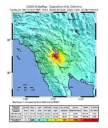
| Max. intensity | VIII (Severe) |
| Peak acceleration | 0.36 g at El Centro-Imperial County (2nd main shock) |
| Casualties | 2 dead, 90+ injured |
Geology
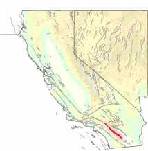
Both mainshocks were situated in the Salton Trough, a pull-apart basin caused by extension between offset strike-slip faults. The Brawley Seismic Zone is an area of extension and small divergent plate boundary that connects the Imperial Fault with the San Andreas Fault. Earthquake swarms are common in the fault zone, with the last one in 2020.[2] The San Jacinto Fault is a long, active strike-slip fault in Southern California that is part of the San Andreas Fault which accommodates the motion between the North American and Pacific Plate. The Imperial Valley is one of the most seismically active areas in California. There have been earthquakes of M 6 or greater in 1915, 1940, and 1979, with the strongest, an M 6.7 quake that killed seven people in 1940. The geological forces that caused the November 23-24, 1987, earthquakes are the same ones that rifted Baja California from Mexico to form the Sea of Cortez.
Earthquake
The earthquakes consisted of two main shocks; the Mw 6.2 that was followed by an Mw 6.6 eleven hours later. Both epicenters are located within Imperial County, near the Salton Sea.
November 23 1987
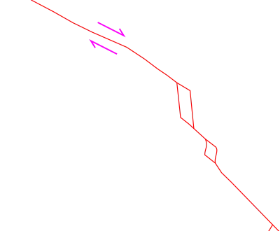
The first shock occurred at 5:53 pm along a previously undetected north-east striking structure. It was associated with left-lateral (sinistral) fault rupture and had a maximum offset of 12.5 cm. The epicenter was located in a sparsely populated area 22.5 km north of Westmorland.[3]
November 24 1987
The second main shock was larger and it was caused by movement on the Superstition Hills and Superstition Mountain faults, which are part of the San Jacinto Fault Zone, along which ground rupture was observed.[4] This event occurred at 5:16 am, nearly 12 hours later and centered 9.7 km southwest of the first quake. Right-lateral (dextral) rupture that was seen for 27 km. A maximum of 65 cm of dextral offset was measured on December 2, 1987.[3]
Impact
Imperial Valley
The first earthquake forced the closure of a runway at the Naval Air Facility, El Centro but no damage was found after inspection.[5] Telephone services were affected because the earthquake had destroyed some lines. The shaking triggered an "unusual event" declaration at the San Onofre nuclear plant, but the facility was unaffected.
Damage was reported at El Centro, Imperial and Westmorland. Fallen chimneys, pipes, and windows were seen in properties. Some roads needed to be replaced because they were offset or cracked from liquefaction. About 40 mobile homes were wrenched from their stands. The Southern California Irrigation District estimated $600,000 to $750,000 worth of damage to canal facilities.[6] The initial earthquake resulted in minor buckling of the canal concrete reinforce while the second shock collapsed many of the concrete.[6] In Calexico, the wall of a furniture store collapsed on automobiles, and in El Centro, another brick wall fell onto a car. Many homes and businesses lost power following the earthquake. Fifty people were injured in Imperial County. California 86 between Westmorland and El Centro was damaged and closed off. California 98 was closed at Ocotillo at the junction with Interstate 8 after a road buckled. The entry station between Mexicali and Calexico was closed for damage inspection.[7]
Los Angeles
Tremors were felt but there was no damage. Los Angeles County fire dispatcher reported calls from residents asking if there had been an earthquake.[5] Many people were frightened by the earthquake, in the wake of the Whittier Narrows quake two months earlier. In Orange County, people started stoking up in survival appliances such as water purification tablets and water bottles for their earthquake preparedness kits. The California Department of Transportation began inspecting freeways for possible damage.[7] This region experienced a deadly earthquake that killed eight on October 1 the same year.
San Diego
The first event struck while city councils were having a conference on the 12th floor, shaking caused some turmoil in the room.[5] The San Diego Fire Department reported minor cracks to five of their stations.[7]
Mexico
Forty-four were injured in Mexico. The injuries included broken bones, sprains, cuts, and some heart attacks. In Mexicali, hundreds evacuated from buildings, and 35 were damaged, including several hospitals.[7] Structural damage and fires were reported.[8] Two people, a woman and her child were killed as they were fleeing a factory and was struck by an oncoming vehicle.
References
- "M 5.9 - 2km SSW of Rosemead, CA". United States Geological Survey ANSS. Retrieved 21 November 2020.
- Wigglesworth, Alex (1 October 2020). "More than 600 earthquakes strike small California town in swarm around Salton Sea". Los Angeles Times.
- "Earthquakes Strike Imperial Valley in "Superstition Hills Sequence"". California Geology. 41. 1988.
- Magistrale, Harold; Jones, Lucile; Kanamori, Hiroo (April 1989). "The Superstition Hills, California, earthquakes of 24 November 1987" (PDF). Bulletin of the Seismological Society of America. 79 (2): 239–251. ISSN 0037-1106.
- Feldman, Paul; Reza, H.G. (24 November 1987). "Imperial Valley Rocked by 6.2 Quake; Damage Minor". Los Angeles Times. Retrieved November 21, 2020.
- Carl W Stover, Jerry L Coffman (1993). Seismicity of the United States, 1568-1989 (revised). United States: United States Government Printing Office.
- Kenneth Reich, H. G. Reza (25 November 1987). "6.3 Quake Injures 94 Along Mexican Border: Imperial Valley Temblor, 2nd in 12 Hours, Damages Buildings in Mexicali, El Centro". Los Angeles Times.
- "California gets more reminders of quake potential. Experts say temblors that hit the lower Imperial Valley and Mexicali, Mexico don't mean more are likely to follow soon". The Christian Science Monitor. 1987.
Municipalities and communities of Imperial County, California, United States | ||
|---|---|---|
| Cities | 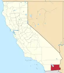 Imperial County map | |
| CDPs | ||
| Unincorporated communities | ||
| Indian reservations | ||
| Ghost towns | ||
| ||