1999 Oklahoma tornado outbreak
The 1999 Oklahoma tornado outbreak was a significant tornado outbreak that affected much of the Central and parts of the Eastern United States, with the highest record-breaking wind speeds of 302 ± 22 mph (486 ± 35 km/h). During this week-long event, 154 tornadoes touched down (including one in Canada), more than half of them on May 3 and 4 when activity reached its peak over Oklahoma, Kansas, Nebraska, Texas, and Arkansas.
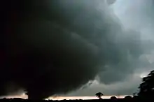
 A tornado near Anadarko, Oklahoma, on May 3 | |
| Duration | May 2–8, 1999 |
|---|---|
| Tornadoes confirmed | 152 |
| Max. rating1 | F5 tornado |
| Duration of tornado outbreak2 | 7 days |
| Highest winds |
|
| Largest hail | 4.5 in (11 cm) in diameter (multiple locations on May 3)[3] |
| Damage | $1.4 billion[4] |
| Casualties | 50 fatalities (+7 non-tornadic), 895 injuries |
| Areas affected | Central and Eastern United States |
Part of the Tornadoes of 1999 1Most severe tornado damage; see Fujita scale 2Time from first tornado to last tornado | |
The most significant tornado first touched down southwest of Chickasha, Oklahoma, and became an F5 before dissipating near Midwest City. The tornado tore through southern and eastern parts of Oklahoma City and its suburbs of Bridge Creek, Moore, Del City, Tinker Air Force Base and Midwest City, killing 36 people, destroying more than 8,000 homes, and causing $1.5 billion in damage. With a total of 72 tornadoes, it was the most prolific tornado outbreak in Oklahoma history, although not the deadliest.
Meteorological synopsis

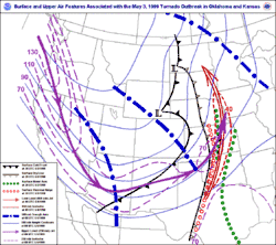
The outbreak was caused by a vigorous upper-level trough that moved into the Central and Southern Plains states on the morning of May 3. That morning, low stratus clouds overspread much of Oklahoma, with clear skies along and west of a dry line located from Gage to Childress, Texas. Air temperatures at 7:00 a.m. Central Daylight Time ranged in the mid to upper 60s °F (upper 10s to near 20 °C) across the region, while dew point values ranged in the low to mid 60s °F (mid to upper 10s °C).[5] The Storm Prediction Center (SPC) in Norman, Oklahoma, a division of the National Weather Service, initially issued a slight risk of severe thunderstorms early that morning stretching from the Kansas-Nebraska border to parts of southern Texas, with an intended threat of large hail, damaging winds and tornadoes.[6]
.gif)
By late morning, the low cloud cover began to dissipate in advance of the dry line, but during the afternoon hours high cirrus clouds overspread the region, resulting in filtered sunshine in some areas that caused atmospheric destabilization. The sunshine and heating, combined with abundant low-level moisture, combined to produce a very unstable air mass. Upper air balloon soundings observed strong directional wind shear, cooling temperatures at high atmospheric levels, and the increased potential of CAPE values potentially exceeding 4000 J/kg, levels that are considered favorable for supercells and tornadoes.
As observations and forecasts began to indicate an increasing likelihood of widespread severe weather conditions even more favorable for strong tornadoes, the SPC issued a moderate risk of severe weather at 11:15 a.m. CDT for portions of Kansas, Oklahoma and Texas along and near the Interstate 40 corridor.[7] By 3:00 p.m. CDT, it had become evident that a widespread severe weather event was imminent; the Storm Prediction Center upgraded locations within the moderate risk area to a high risk of severe weather around 4:00 p.m. CDT as wind shear profiles, combined with volatile atmospheric conditions, had made conditions highly conducive for a significant tornadic event across most of Oklahoma, southern Kansas and north Texas, including the likelihood of violent, damaging tornadoes.[7] The SPC issued a tornado watch by mid-afternoon as conditions gathered together for what would be a historic tornado outbreak. By the time thunderstorms began developing in the late-afternoon hours, CAPE values over the region had reached to near 6,000 J/kg. Large supercell thunderstorms developed and in the late afternoon through the mid-evening hours of that Monday, tornadoes began to break out across the state.
Notable tornadoes
| FU | F0 | F1 | F2 | F3 | F4 | F5 | Total |
|---|---|---|---|---|---|---|---|
| 0 | 73 | 44 | 20 | 10 | 4 | 1 | 152 |
- Note: The above amount refers to the rest of the outbreak, not just the ones confirmed in Oklahoma.
Bridge Creek–Moore, Oklahoma
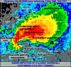
At approximately 3:30 p.m. CDT, a severe thunderstorm began forming in Tillman County in southwestern Oklahoma; a severe thunderstorm warning was issued for this storm by the National Weather Service Weather Forecast Office in Norman at 4:15 p.m. CDT. The storm quickly developed supercell characteristics and began exhibiting potentially tornadic rotation, resulting in the National Weather Service issuing the first tornado warning of the event for Comanche, Caddo and Grady counties approximately 35 minutes later at 4:50 p.m. CDT.
The first tornado from this supercell touched down 7 miles (11 km) east-northeast of Medicine Park at 4:51 p.m. CDT; it produced four additional tornadoes as it tracked northeast into Caddo County, the strongest of which (rated as an F3) touched down 2 miles (3.2 km) west-southwest of Laverty and dissipated 2.5 miles (4.0 km) west-northwest of downtown Chickasha. This large tornado had exhibited a companion satellite tornado for a few minutes.[8]
The storm produced the most significant tornado of the outbreak, which touched down just southwest of the Grady County community of Amber at 6:23 p.m. CDT and headed northeast, parallel to Interstate 44, just after another tornado had passed over the airport in Chickasha. The storm continued moving northeast, destroying the community of Bridge Creek and crossing I-44 just north of Newcastle. The tornado then crossed the Canadian River, passing into far southern Oklahoma City. As it passed over Bridge Creek, around 6:54 p.m., a Doppler On Wheels mobile Doppler weather radar detected wind speeds of 302 ± 22 mph (486 ± 35 km/h) inside the tornado at an elevation of 105 ft (32 m).[9] These winds, however, occurred above the ground, and winds at the surface may not have been quite this intense. The tornado continued on into Moore, then passed over the intersection of Shields Boulevard and Interstate 35 and back into Oklahoma City, crossing Interstate 240 near Bryant Avenue. The storm then turned more northerly, striking parts of Del City and Tinker Air Force Base near Sooner Road as an F4. The storm damaged and/or destroyed several businesses, homes and churches in Midwest City. Some damage in this area was rated as high-end F4, although F5 was considered. The tornado diminished over Midwest City and finally lifted near the intersection of Reno Avenue and Woodcrest Drive.
36 people died in this tornado,[10] and over 8,000 homes were badly damaged or destroyed. The tornado caused $1 billion in damage, making it the second-costliest tornado in U.S. history,[11] and the most costly in history from 1999 to 2011, at which point it was surpassed by the 2011 Tuscaloosa–Birmingham tornado and again by the 2011 Joplin tornado. It was also the deadliest tornado to hit the U.S. since the April 10, 1979 F4 tornado that hit Wichita Falls, Texas, which killed 42 people.[12]
Cimarron City–Mulhall–Perry, Oklahoma

| Outbreak Death Toll | |||
|---|---|---|---|
| State | Fatalities | County | County total |
| Kansas | 6 | Sedgwick | 6 |
| Oklahoma | 40 | Cleveland | 11 |
| Grady | 12 | ||
| Kingfisher | 1 | ||
| Logan | 1 | ||
| McClain | 1 | ||
| Payne | 1 | ||
| Pottawatomie | 1 | ||
| Oklahoma | 12 | ||
| Tennessee | 3 | Perry | 3 |
| Texas | 1 | Titus | 1 |
| Totals | 50 | ||
| All deaths were tornado-related | |||
Late in the evening on May 3 at 9:25 p.m. CDT, a destructive tornado touched down 3 miles (4.8 km) southwest of Cimarron City in Logan County, Oklahoma, eventually hitting the town of Mulhall, located north of Guthrie. This wedge tornado, which tracked a 35-mile (56 km) path, was very wide and at times exceeded one mile (1.6 km) in width. According to storm chasing meteorologist Roger Edwards, it may have been as violent or more than the F5 Bridge Creek–Moore tornado (however, it was officially rated as an F4).[13]
A Doppler On Wheels (DOW) mobile radar observed this tornado as it crossed Mulhall. The DOW documented the largest-ever-observed core flow circulation with a distance of 1,600 m (5,200 ft) between peak velocities on either side of the tornado, and a roughly 7 km (4.3 mi) width of peak wind gusts exceeding 43 m/s (96 mph), making the Mulhall tornado the largest tornado ever measured quantitatively.[14] The DOW measured a complex multi-vortex structure,[15] with several vortices containing winds of up to 115 m/s (260 mph) rotating around the tornado. The 3D structure of the tornado has been analyzed in a 2005 article in the Journal of the Atmospheric Sciences by Wen-Chau Lee and Joshua Wurman.[16] The tornado severely damaged or destroyed approximately 60–70% of the 130 homes in Mulhall, destroying the Mulhall/Orlando Elementary School and toppling the city's water tower.
After the tornado dissipated at approximately 10:45 p.m. CDT in southeastern Noble County, 3 miles (4.8 km) northeast of Perry, many of the same areas of Logan County struck by the Mulhall tornado were hit again by an F3 tornado produced by a separate supercell that touched down 2.5 miles (4.0 km) south of Crescent at 11:33 p.m. CDT. Damage caused by this tornado was indistinguishable from damage caused by the earlier F4 tornado. 25 homes were destroyed and 30 others were damaged near Crescent, with much of the damage believed to have been caused by both tornadoes.
Stroud, Oklahoma
At 10:10 p.m. CDT, a damaging tornado touched down 3 miles (4.8 km) north-northeast of Sparks in Lincoln County, Oklahoma, with only sporadic tree damage occurring as it tracked north-northeast toward Davenport. Scattered damage of high-end F0 to low-end F1 intensity occurred to some homes and businesses on the southeast side of Davenport, though a house located just south of town lost more than half of its roof. As the tornado continued to track northeast, parallel with Interstate 44 and State Highway 66, Stroud took a direct hit as the storm intensified to F2 strength; the trucking terminal of the Sygma food distribution warehouse on the west side of town was destroyed with some girders and siding from the warehouse thrown northwest across State Highway 66, and the Stroud Municipal Hospital suffered significant roof damage, which resulted in significant water damage within the building. The most severe damage, consistent with an F3 tornado, occurred at the Tanger Outlet Mall at 10:39 p.m. CDT with almost all of the stores suffering roof damage at minimum, though sections of seven storefronts were destroyed and the exterior walls of the Levi's store were collapsed inward. The mall was evacuated in advance of the tornado, resulting in no injuries or loss of life in the building. The tornado finally dissipated 1 mile (1.6 km) south of Stroud Lake at 11:48 p.m. CDT.
While there were no fatalities overall in Stroud, the economic impact of the tornado has been compared to the loss of Tinker Air Force Base, General Motors, and a major regional hospital for the Stroud region as compared to Oklahoma City at that time. Approximately 800 jobs were lost in a community of approximately 3,400 people due to the damage of the Sygma distribution warehouse and Tanger Outlet Mall, neither of which were rebuilt.[17] Stroud's recovery was later complicated by the September 11, 2001, terrorist attacks, although the town has since recovered as a result of higher oil and gas prices. Local leading industries include Service King, an oilfield manufacturing facility, and Mint Turbines, a helicopter engine reconditioning facility. Stroud is also now a downloading facility location for oil produced in the northern United States into the Cushing pipeline network.
Other tornadoes
The May 3 tornado event was part of a three-day event that included tornadoes in the states of Kansas, Texas and Tennessee. A deadly F4 tornado that tracked 24 miles (39 km) across south-central Kansas killed six people in Haysville and Wichita during the late evening of May 3. Other fatalities during the event included one person killed in Texas on May 4 by an F3 tornado that tracked 71.5 miles (115.1 km) from near Winfield, Texas, to southwest of Mineral Springs, Arkansas, and three people killed in Tennessee on May 5 and 6 by an F4 tornado that struck the town of Linden.[18]
Non-tornadic events
Flash flooding killed one person in Camden County, Missouri, on May 4.[19] On May 6, lightning struck and killed a man in Cobbtown, Georgia.[20]
Aftermath
Disaster assistance
| Structural damage in Oklahoma[21] | |||
|---|---|---|---|
| Oklahoma and Cleveland Counties |
Other counties | ||
| Homes destroyed | 1,780 | 534 | |
| Homes damaged | 6,550 | 878 | |
| Businesses destroyed | 85 | 79 | |
| Businesses damaged | 42 | 54 | |
| Public buildings destroyed | 4 | 7 | |
| Apartments destroyed | 473 | 568 | |
On May 3–4, the day after the initial outbreak event, President Bill Clinton signed a federal disaster declaration for eleven Oklahoma counties. In a press statement by the Federal Emergency Management Agency (FEMA), then-director James Lee Witt stated that "The President is deeply concerned about the tragic loss of life and destruction caused by these devastating storms."[22] The American Red Cross opened ten shelters overnight, housing 1,600 people immediately following the disaster, decreasing to 500 people by May 5. On May 5, several emergency response and damage assessment teams from FEMA were deployed to the region. The United States Department of Defense deployed the 249th Engineering Battalion and placed the U.S. Army Corps of Engineers on standby for assistance. Medical and mortuary teams were also sent by the U.S. Department of Health and Human Services.[23] By May 6, donation centers and phone banks were being established to create funds for victims of the tornadoes.[24] Within the first few days of the disaster declaration, relief funds were sent to families requesting aid. Roughly $180,000 had been approved by FEMA for disaster housing assistance by May 9.[25]
Debris removal began on May 12 as seven cleanup teams were sent to the region with more teams expected to join over the following days.[26] That day, FEMA also granted seven Oklahoma counties (Canadian, Craig, Grady, Lincoln, Logan, Noble and Oklahoma) eligibility for federal financial assistance.[27] Roughly $1.6 million in disaster funds had been approved for housing and businesses loans by May 13,[28] increasing to more than $5.9 million over the following five days.[29] Applications for federal aid continued through June, with state aid approvals reaching $54 million on June 3. According to FEMA, more than 9,500 Oklahoma residents applied for federal aid during the allocated period in the wake of the tornadoes, including 3,800 in Oklahoma County and 3,757 in Cleveland County. Disaster recovery aid for the tornadoes totaled to roughly $67.8 million by July 2.[30]
Concerns with using overpasses as storm shelters
From a meteorological and safety standpoint, the tornado called into question the use of highway overpasses as shelters from tornadoes. Prior to the events on May 3, 1999, videos of people taking shelter in overpasses during tornadoes in the past (such as an infamous video from the April 26, 1991 tornado outbreak taken by a news crew from Wichita NBC affiliate KSNW) created public misunderstanding and complacency that overpasses provided adequate shelter from tornadoes. Although meteorologists had questioned the safety of these structures for nearly 20 years, there had been no evidence supporting incidents involving loss of life.[31] Three overpasses were directly struck by tornadoes during the May 3 outbreak, resulting in fatalities at each location. Two occurred as a result of the Bridge Creek–Moore F5, while the third occurred in rural Payne County, which was struck by an F2 tornado.[32] According to a study by the National Oceanic and Atmospheric Administration, seeking shelter in an overpass "is to become a stationary target for flying debris"; the wind channeling effect that occurs within these structures along with an increase in wind speeds above ground level, changing of wind direction when the tornado vortex passes, and the fact most overpasses do not have girders for people to take shelter between also provide little to no protection.[33]
See also
| Wikimedia Commons has media related to 1999 Oklahoma tornado outbreak. |
References
- "Doppler On Wheels". 3 May 1999. Archived from the original on 5 February 2007. Retrieved 13 June 2013.
- "Tennessee Event Report: Thunderstorm Wind". National Climatic Data Center. National Oceanic and Atmospheric Administration. 2013. Retrieved June 9, 2013.
- "Storm Events Database: May 2–8, 1999 Hail 4.00 in and Larger". National Climatic Data Center. National Oceanic and Atmospheric Administration. 2013. Archived from the original on March 4, 2016. Retrieved June 9, 2013.
- "Storm Events Database: May 2–7, 1999 Tornadoes". National Climatic Data Center. National Oceanic and Atmospheric Administration. 2013. Archived from the original on 2016-03-04. Retrieved June 9, 2013.
- Meteorological Summary of the Great Plains Tornado Outbreak of May 3-4, 1999
- "Severe Weather Outlook at 6:30 a.m. CDT on May 3, 1999".
- "Severe Weather Outlook at 11:15 a.m. CDT on May 3, 1999".
- Wurman, Joshua; K. Kosiba (2013). "Finescale Radar Observations of Tornado and Mesocyclone Structures". Weather Forecast. 28 (5): 1157–74. Bibcode:2013WtFor..28.1157W. doi:10.1175/WAF-D-12-00127.1.
- "Doppler On Wheels". Center for Severe Weather Research. 2010. Archived from the original on February 5, 2007. Retrieved October 1, 2010.
- Service, US Department of Commerce, NOAA, National Weather. "The Great Plains Tornado Outbreak of May 3-4, 1999 - Storm A Information". www.weather.gov.
- However, adjustment for growth in wealth shows the May 27, 1896 Saint Louis–East Saint Louis tornado to be the costliest on record. See Brooks, Harold E.; Doswell III; Charles A. (2001). "Normalized Damage from Major Tornadoes in the United States: 1890–1999" (PDF). Weather and Forecasting. 16 (1): 168–176. Bibcode:2001WtFor..16..168B. doi:10.1175/1520-0434(2001)016<0168:NDFMTI>2.0.CO;2. ISSN 1520-0434.
- Brooks, Harold E.; Doswell III; Charles A. (2002). "Deaths in the 3 May 1999 Oklahoma City Tornado from a Historical Perspective". Weather and Forecasting. 17 (3): 354–361. Bibcode:2002WtFor..17..354B. doi:10.1175/1520-0434(2002)017<0354:DITMOC>2.0.CO;2. ISSN 1520-0434.
- "Central Oklahoma Tornado Intercept: 3 May 1999 (Roger Edwards)". www.stormeyes.org.
- Wurman, Joshua; C. Alexander; P. Robinson; Y. Richardson (January 2007). "Low-Level Winds in Tornadoes and Potential Catastrophic Tornado Impacts in Urban Areas". Bulletin of the American Meteorological Society. American Meteorological Society. 88 (1): 31–46. Bibcode:2007BAMS...88...31W. doi:10.1175/BAMS-88-1-31.
- Wurman, Joshua (June 2002). "The Multiple-Vortex Structure of a Tornado". Weather Forecast. 17 (3): 473–505. Bibcode:2002WtFor..17..473W. doi:10.1175/1520-0434(2002)017<0473:TMVSOA>2.0.CO;2. ISSN 1520-0434.
- Lee, Wen-Chau; J. Wurman (July 2005). "Diagnosed Three-Dimensional Axisymmetric Structure of the Mulhall Tornado on 3 May 1999". J. Atmos. Sci. 62 (7): 2373–93. Bibcode:2005JAtS...62.2373L. doi:10.1175/JAS3489.1.
- "History of Tanger Factory Outlet Centers, Inc. – FundingUniverse". www.fundinguniverse.com.
- "Linden F4 Tornado of May 5, 1999". Srh.noaa.gov. Retrieved 2012-08-15.
- "Missouri Event Report: Flash Flood". National Climatic Data Center. National Oceanic and Atmospheric Administration. 2013. Retrieved June 9, 2013.
- "Georgia Event Report: Lightning". National Climatic Data Center. National Oceanic and Atmospheric Administration. 2013. Retrieved June 9, 2013.
- "The 1999 Oklahoma Tornado Outbreak: 10-Year Retrospective" (PDF). Risk Management Solutions. 2009. Retrieved October 2, 2010.
- "President Declares Major Disaster for Oklahoma". Federal Emergency Management Agency. May 4, 1999. Archived from the original on June 7, 2010. Retrieved October 2, 2010.
- "Oklahoma/Kansas Tornado Disaster Update". Federal Emergency Management Agency. May 5, 1999. Archived from the original on June 7, 2010. Retrieved October 2, 2010.
- "Plains States Tornado Update". Federal Emergency Management Agency. May 6, 1999. Archived from the original on June 7, 2010. Retrieved October 2, 2010.
- "First Checks Approved for Oklahoma Storm Victims". Federal Emergency Management Agency. May 9, 1999. Archived from the original on June 7, 2010. Retrieved October 2, 2010.
- "Debris Removal Underway in Oklahoma City, Mulhall, and Choctaw; Stroud Set for Thursday". Federal Emergency Management Agency. May 12, 1999. Archived from the original on June 7, 2010. Retrieved October 2, 2010.
- "Seven Oklahoma Counties Get Expanded Disaster Assistance". Federal Emergency Management Agency. May 12, 1999. Archived from the original on June 7, 2010. Retrieved October 2, 2010.
- "Oklahoma Tornado Disaster Update". Federal Emergency Management Agency. May 13, 1999. Archived from the original on June 7, 2010. Retrieved October 2, 2010.
- "Oklahoma Disaster Recovery News Summary". Federal Emergency Management Agency. May 18, 1999. Archived from the original on June 7, 2010. Retrieved October 2, 2010.
- "Almost 9,500 Oklahomans Register For Disaster Recovery Aid More Than $67.8 Million In Grants And Loans Approved". Federal Emergency Management Agency. July 7, 1999. Archived from the original on June 8, 2010. Retrieved October 3, 2010.
- Daniel J. Miller; Charles A. Doswell III; Harold E. Brooks; Gregory J. Stumpf; Erik Rasmussen (1999). "Highway Overpasses as Tornado Shelters". National Weather Service in Norman, Oklahoma. p. 1. Archived from the original on 13 November 2010. Retrieved October 3, 2010.
- Daniel J. Miller; Charles A. Doswell III; Harold E. Brooks; Gregory J. Stumpf; Erik Rasmussen (1999). "Highway Overpasses as Tornado Shelters: Events on May 3, 1999". National Weather Service in Norman, Oklahoma. p. 5. Retrieved October 3, 2010.
- Daniel J. Miller; Charles A. Doswell III; Harold E. Brooks; Gregory J. Stumpf; Erik Rasmussen (1999). "Highway Overpasses as Tornado Shelters: Highway Overpasses Are Inadequate Tornado Sheltering Areas". National Weather Service in Norman, Oklahoma. p. 6. Retrieved October 3, 2010.
External links
- May 3, 1999 Oklahoma Tornado Special Report - The Oklahoman
- Great Plains Outbreak of 1999 Tornado History Project
- The Great Plains Tornado Outbreak of May 3-4, 1999 (National Weather Service, Norman, Oklahoma)
- The 3 May 1999 Oklahoma Tornadoes (David Schultz, CIMMS)
- Google Maps' location of Stroud, Oklahoma, with the bulldozed lot of the former Tanger Outlet Mall in the upper left of the screen, just north of Interstate 44
- May 3 Oklahoma Tornado Special video section from KOCO-TV
- Moore, Oklahoma Tornado Photos, May 1999 Aerial Photos of Moore Oklahoma taken three days after the May 3, 1999, tornado
- Anastassia M., Makarieva; Gorshkov, Victor G.; Nefiodov, Andrei V. (2012). "Condensational theory of stationary tornadoes". Physics Letters A. 375 (24): 2259–2261. arXiv:1208.2580. Bibcode:2011PhLA..375.2259M. doi:10.1016/j.physleta.2011.04.023.
