Grady County, Oklahoma
Grady County is a county located in the U.S. state of Oklahoma. As of the 2010 census, the population was 52,431.[1] Its county seat is Chickasha.[2] It was named for Henry W. Grady, an editor of the Atlanta Constitution and southern orator.[3]
Grady County | |
|---|---|
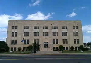 Grady County Courthouse in Chickasha (2014) | |
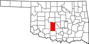 Location within the U.S. state of Oklahoma | |
 Oklahoma's location within the U.S. | |
| Coordinates: 35°01′N 97°53′W | |
| Country | |
| State | |
| Founded | 1907 |
| Named for | Henry W. Grady |
| Seat | Chickasha |
| Largest city | Chickasha |
| Area | |
| • Total | 1,105 sq mi (2,860 km2) |
| • Land | 1,100 sq mi (3,000 km2) |
| • Water | 4.4 sq mi (11 km2) 0.4%% |
| Population (2010) | |
| • Total | 52,431 |
| • Estimate (2019) | 55,834 |
| • Density | 50/sq mi (20/km2) |
| Time zone | UTC−6 (Central) |
| • Summer (DST) | UTC−5 (CDT) |
| Congressional district | 4th |
| Website | www |
Grady County is part of the Oklahoma City, OK Metropolitan Statistical Area.
History
Grady County was part of the land given to the Choctaw by the Treaty of Dancing Rabbit Creek, in exchange for property in the southeastern United States. In 1837, the Chickasaw joined the Choctaws, and in 1855 a treaty separated the two tribes, and the Chickasaw acquired an area that included much of Grady County. Most of the present Grady County became a part of Pickens County[4] in the Chickasaw Nation.[3]
Before the Civil War, Randolph B. Marcy blazed the California Road through this area, reporting a Waco and a Wichita village. In 1858, while the Comanches were holding a meeting with the Wichita, Choctaw, and Chickasaw, Federal troops attacked a party of Comanches. Although the commander of Fort Arbuckle had been informed about the meeting, the troops' commander, Major Earl Van Dorn, had not consulted him before the attack. As a result, the troops killed 60 Comanches and four Wichitas. Fearing a Comanche reprisal, the other tribes fled to safety at Fort Arbuckle. At the end of the Civil War, the Five Civilized Tribes and the Caddo, Delaware, Kiowa, Comanche, Apache, Cheyenne, Arapaho, and Osage signed a peace agreement and pledged to stand united against any unjust demands that the federal government made at the war's end. The agreement was known as the Camp Napoleon Compact.[3]
The first railroad in this area was built to the town of Minco in 1890 by the Chicago, Kansas and Nebraska Railway. The company was acquired by the Chicago, Rock Island and Pacific Railroad (Rock Island) during the following year. In 1892, the Rock Island built a track connecting Chickasha, Ninnekah, and Rush Springs to the Texas border. The same railroad built a line from Chickasha to Magnum in 1900. The Oklahoma City and Western Railroad (sold to the St. Louis and San Francisco Railway in 1907) constructed tracks from Oklahoma City to Chickasha, which it extended to the Texas border in the following year. Between 1906 and 1910, the Oklahoma Central Railway (sold to the Atchison, Topeka and Santa Fe Railway in 1914) built from Lehigh to Chickasha.[3]
The 1898 Curtis Act stripped the Chickasaw Nation of its authority, and communal land was forced into allotment, paving the way for statehood. When Oklahoma acquired statehood in 1907, the Chickasaw Nation ceased to exist, Grady County was organized and Chickasha was named the county seat. In 1911, Grady County annexed Washington, Prairie Valley, and the northern section of Dutton townships formerly in Caddo County, Oklahoma.[3]
Geography
According to the U.S. Census Bureau, the county has a total area of 1,105 square miles (2,860 km2), of which 1,100 square miles (2,800 km2) is land and 4.4 square miles (11 km2) (0.4%) is water.[5] The county lies in the Red Bed Plains, and is mostly covered with rolling prairie. The Canadian River forms the northern boundary and the Washita River runs through the middle.[3]
Major highways
.svg.png.webp) Interstate 44
Interstate 44 H.E. Bailey Turnpike
 U.S. Highway 62
 U.S. Highway 81
 U.S. Highway 277
 State Highway 9
 State Highway 17
 State Highway 19
 State Highway 92
Adjacent counties
- Canadian County (north)
- McClain County (east)
- Garvin County (southeast)
- Stephens County (south)
- Comanche County (southwest)
- Caddo County (west)
Demographics
| Historical population | |||
|---|---|---|---|
| Census | Pop. | %± | |
| 1910 | 30,309 | — | |
| 1920 | 33,943 | 12.0% | |
| 1930 | 47,638 | 40.3% | |
| 1940 | 41,116 | −13.7% | |
| 1950 | 34,872 | −15.2% | |
| 1960 | 29,590 | −15.1% | |
| 1970 | 29,354 | −0.8% | |
| 1980 | 39,490 | 34.5% | |
| 1990 | 41,747 | 5.7% | |
| 2000 | 45,516 | 9.0% | |
| 2010 | 52,431 | 15.2% | |
| 2019 (est.) | 55,834 | [6] | 6.5% |
| U.S. Decennial Census[7] 1790-1960[8] 1900-1990[9] 1990-2000[10] 2010-2019[1] | |||
As of the census[11] of 2000, there were 45,516 people, 17,341 households, and 12,797 families residing in the county. The population density was 41 people per square mile (16/km2). There were 19,444 housing units at an average density of 18 per square mile (7/km2). The racial makeup of the county was 87.31% White, 3.06% Black or (United States Census), 4.85% Native American, 0.34% Asians, 0.04% Pacific Islander, 1.12% from other races, and 3.28% from two or more races. 2.89% of the population were Hispanic or Latino of any race.
There were 17,341 households, out of which 34.70% had children under the age of 18 living with them, 60.50% were married couples living together, 9.70% had a female householder with no husband present, and 26.20% were non-families. 22.90% of all households were made up of individuals, and 10.50% had someone living alone who was 65 years of age or older. The average household size was 2.58 and the average family size was 3.02.
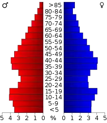
In the county, the population was spread out, with 26.70% under the age of 18, 9.30% from 18 to 24, 27.70% from 25 to 44, 23.20% from 45 to 64, and 13.10% who were 65 years of age or older. The median age was 36 years. For every 100 females, there were 95.30 males. For every 100 females age 18 and over, there were 91.30 males.
The median income for a household in the county was $32,625, and the median income for a family was $39,636. Males had a median income of $30,306 versus $21,108 for females. The per capita income for the county was $15,846. About 10.40% of families and 13.90% of the population were below the poverty line, including 16.90% of those under age 18 and 14.60% of those age 65 or over.
Politics
| Voter Registration and Party Enrollment as of January 15, 2019[12] | |||||
|---|---|---|---|---|---|
| Party | Number of Voters | Percentage | |||
| Democratic | 9,664 | 29.93% | |||
| Republican | 17,758 | 55.01% | |||
| Others | 4,862 | 15.06% | |||
| Total | 32,284 | 100% | |||
| Year | Republican | Democratic | Third parties |
|---|---|---|---|
| 2016 | 77.7% 17,316 | 17.4% 3,882 | 4.9% 1,088 |
| 2012 | 75.6% 14,833 | 24.4% 4,786 | |
| 2008 | 73.4% 15,195 | 26.7% 5,520 | |
| 2004 | 70.3% 14,136 | 29.7% 5,970 | |
| 2000 | 61.7% 10,040 | 37.1% 6,037 | 1.2% 199 |
| 1996 | 46.3% 7,228 | 40.1% 6,256 | 13.6% 2,114 |
| 1992 | 39.4% 6,997 | 34.8% 6,177 | 25.8% 4,583 |
| 1988 | 53.8% 7,994 | 45.1% 6,689 | 1.1% 165 |
| 1984 | 69.2% 11,042 | 30.4% 4,846 | 0.5% 72 |
| 1980 | 58.2% 8,131 | 38.2% 5,330 | 3.7% 510 |
| 1976 | 39.2% 4,686 | 59.9% 7,155 | 1.0% 114 |
| 1972 | 67.5% 7,762 | 29.9% 3,440 | 2.6% 297 |
| 1968 | 38.2% 4,242 | 42.8% 4,760 | 19.0% 2,117 |
| 1964 | 32.0% 3,569 | 68.0% 7,593 | |
| 1960 | 52.1% 5,913 | 47.9% 5,446 | |
| 1956 | 43.4% 5,191 | 56.6% 6,773 | |
| 1952 | 45.2% 6,348 | 54.8% 7,710 | |
| 1948 | 26.2% 2,882 | 73.8% 8,136 | |
| 1944 | 34.6% 4,069 | 65.3% 7,689 | 0.2% 20 |
| 1940 | 34.6% 4,299 | 65.0% 8,075 | 0.4% 43 |
| 1936 | 24.9% 3,013 | 74.6% 9,025 | 0.5% 61 |
| 1932 | 18.0% 2,034 | 82.0% 9,247 | |
| 1928 | 62.6% 6,332 | 36.3% 3,667 | 1.1% 110 |
| 1924 | 30.8% 2,640 | 59.3% 5,091 | 10.0% 855 |
| 1920 | 41.7% 3,403 | 52.4% 4,277 | 5.9% 478 |
| 1916 | 23.8% 1,272 | 60.6% 3,243 | 15.7% 841 |
| 1912 | 25.1% 1,121 | 57.7% 2,577 | 17.3% 772 |
Communities
NRHP sites
The following sites in Grady County are listed on the National Register of Historic Places:
- Chickasha Downtown Historic District, Chickasha
- Grady County Courthouse, Chickasha
- Griffin House, Chickasha
- Jewett Site, Bradley
- Knippelmeir Farmstead, Minco vicinity
- Minco Armory, Minco
- New Hope Baptist Church, Chickasha
- Oklahoma College for Women Historic District, Chickasha
- Pocasset Gymnasium, Pocasset
- Rock Island Depot, Chickasha
- Silver City Cemetery, Tuttle
- US Post Office and Federal Courthouse, Chickasha
- Verden Separate School, originally in Verden but relocated to Chickasha
References
- "State & County QuickFacts". United States Census Bureau. Archived from the original on June 6, 2011. Retrieved November 9, 2013.
- "Find a County". National Association of Counties. Archived from the original on May 31, 2011. Retrieved June 7, 2011.
- O'Dell, Larry. Encyclopedia of Oklahoma History and Culture - Grady County accessed March 6, 2015
- Charles Goins, Historical Atlas of Oklahoma (Norman: University of Oklahoma Press, 2006), plate 105.
- "2010 Census Gazetteer Files". United States Census Bureau. August 22, 2012. Retrieved February 21, 2015.
- "County Population Totals and Components of Change: 2010-2019". United States Census Bureau. Retrieved March 25, 2020.
- "U.S. Decennial Census". United States Census Bureau. Retrieved February 21, 2015.
- "Historical Census Browser". University of Virginia Library. Retrieved February 21, 2015.
- Forstall, Richard L., ed. (March 27, 1995). "Population of Counties by Decennial Census: 1900 to 1990". United States Census Bureau. Retrieved February 21, 2015.
- "Census 2000 PHC-T-4. Ranking Tables for Counties: 1990 and 2000" (PDF). United States Census Bureau. April 2, 2001. Retrieved February 21, 2015.
- "U.S. Census website". United States Census Bureau. Retrieved January 31, 2008.
- "Oklahoma Registration Statistics by County" (PDF). OK.gov. January 15, 2019. Retrieved February 27, 2019.
- Leip, David. "Dave Leip's Atlas of U.S. Presidential Elections". uselectionatlas.org. Retrieved March 29, 2018.
Further reading
External links
- Encyclopedia of Oklahoma History and Culture - Grady County
- Oklahoma Digital Maps: Digital Collections of Oklahoma and Indian Territory
Places adjacent to Grady County, Oklahoma | |
|---|---|
Municipalities and communities of Grady County, Oklahoma, United States | ||
|---|---|---|
| Cities | Grady County map | |
| Towns | ||
| Unincorporated communities | ||
| Ghost towns | ||
| Indian reservation | ||
| Footnotes | ‡This populated place also has portions in an adjacent county or counties | |
| ||
Oklahoma City (capital) | ||
| Topics |
|  |
| Society |
| |
| Regions | ||
| Largest cities | ||
| Counties |
| |
| Authority control |
|---|