Alexander 134
Alexander 134 is an Indian reserve of the Alexander First Nation in Alberta, located within Sturgeon County.[4] It is located about 40 km (25 mi) northwest of Edmonton.[3] In the 2016 Canadian Census, it recorded a population of 1,099 living in 272 of its 349 total private dwellings.[2] The reserve has the name of Alexander Arcand, a tribal leader.[1]
Alexander 134 | |
|---|---|
| Alexander Indian Reserve No. 134 | |
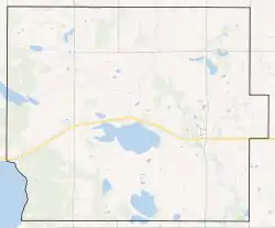 Boundaries of Alexander 134 | |
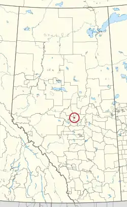 Location in Alberta | |
| Coordinates: 53°48′44″N 113°57′32″W | |
| First Nation | Alexander First Nation |
| Treaty | 6 |
| Country | Canada |
| Province | Alberta |
| Municipal district | Sturgeon County |
| Formed | 1882[1] |
| Area | |
| • Total | 68.39 km2 (26.41 sq mi) |
| Elevation | 695 m (2,280 ft) |
| Population (2016)[2] | |
| • Total | 1,099 |
| • Density | 16/km2 (42/sq mi) |
| Time zone | UTC−07:00 (MST) |
| • Summer (DST) | UTC−06:00 (MDT) |
| Forward sortation areas | T0G |
| Area code(s) | 780, 587, 825 |
| Highways | Highway 642 |
| Waterways | Sandy Lake |
References
- Place-names of Alberta. Ottawa: Geographic Board of Canada. 1928. p. 10.
- "Census Profile, 2016 Census". Statistics Canada. February 8, 2017. Retrieved 2019-08-10.
- "Reserve/Settlement/Village Detail". Indigenous and Northern Affairs Canada. Government of Canada. Retrieved August 12, 2019.
- Government of Alberta (May 25, 2019). Municipal Boundaries (Map). AltaLIS.
| Ethnolinguistic groups | |||||||||||||||||||||||||||
|---|---|---|---|---|---|---|---|---|---|---|---|---|---|---|---|---|---|---|---|---|---|---|---|---|---|---|---|
| Historical polities | |||||||||||||||||||||||||||
| Numbered Treaties | |||||||||||||||||||||||||||
| Tribal councils and band governments |
| ||||||||||||||||||||||||||
This article is issued from Wikipedia. The text is licensed under Creative Commons - Attribution - Sharealike. Additional terms may apply for the media files.