Alma Parish, New Brunswick
Alma is a civil parish on the Bay of Fundy in the southwestern corner of Albert County, New Brunswick, Canada.[2] It comprises one village and one local service district (LSD), both of which are members of the Southeast Regional Service Commission.[3] The most notable feature of the parish is Fundy National Park
Alma | |
|---|---|
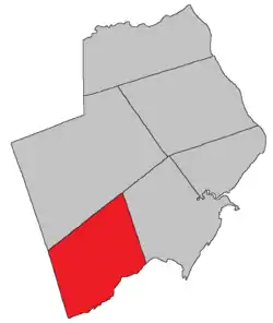 Location within Albert County. | |
| Coordinates: 45.64°N 65.00°W | |
| Country | |
| Province | |
| County | Albert County |
| Erected | 1855 |
| Area | |
| • Land | 222.79 km2 (86.02 sq mi) |
| Population (2011)[1] | |
| • Total | 0 |
| • Density | 0.0/km2 (0/sq mi) |
| • Pop 2006-2011 | |
| • Dwellings | 7 |
| Time zone | UTC-4 (AST) |
| • Summer (DST) | UTC-3 (ADT) |
| Median Income* | $32,995 CDN |
| |
The census subdivision of the same name includes all of the parish[1] except the village of Alma, which forms its own census subdivision. The population of the parish CSD is so small that census numbers are rounded to maintain privacy.
Origin of name
The parish was named for the heights above the Alma River in Crimea where the British forces won a major battle in 1855.[4]
History
Alma Parish was erected from Harvey Parish in 1855.[5]
It is sometimes erroneously described as including part of Saint John County but the county line was moved west in 1837.[6]
Boundaries
Alma Parish is bounded on the south by the Bay of Fundy, on the west by the county line, on the north by a line beginning south of Wolfe Lake and running to the northwestern corner of Hopewell Parish, and on the east by a prolongation of grant lines on the shore near Hebron.[2]
Municipality
The village of Alma contains all of the parish east of Fundy National Park and south of New Ireland Road.[7]
Local service district
The local service district of the parish of Alma legally contains all of the parish not in the village of Alma;[8] in practice the national park is separate from the LSD.
The LSD was established on 1 November 1973[9] to assess for fire protection after the village of Alma was reduced in size from including in the entire parish.[10] Ambulance service was added on 21 January 1976.[11]
Today the LSD assesses for community & recreation services in addition to the basic LSD services of fire protection, police services, land use planning, emergency measures, and dog control[12] The taxing authority is 632.00 Alma.
National park
Fundy National Park is in the southwestern corner of the parish, bounded on the north by Shepody Road and on east by Forty-Five Road, Lake Brook, and the Salmon River. It contains most of the parish and is under federal administration.
Communities
Parish population total does not include incorporated municipalities (in bold).
|
|
|
|
Demographics
Population
| Canada census – Alma Parish, New Brunswick community profile | |||
|---|---|---|---|
| 2011 | 2006 | ||
| Population: | 0 (-100.0% from 2006) | 5 (0.0% from 2001) | |
| Land area: | 222.79 km2 (86.02 sq mi) | 222.79 km2 (86.02 sq mi) | |
| Population density: | 0.0/km2 (0/sq mi) | 0.0/km2 (0/sq mi) | |
| Median age: | n/a (M: n/a, F: n/a) | n/a (M: n/a, F: n/a) | |
| Total private dwellings: | 7 | 6 | |
| Median household income: | $.N/A | $.N/A | |
| Notes: Income & median age data for this area has been suppressed for data quality or confidentiality reasons. – References: 2011[13] 2006[14] earlier[15] | |||
|
|
Access routes
Highways and numbered routes that run through the parish, including external routes that start or finish at the parish limits:[17]
See also
References
- 2011 Statistics Canada Census Profile: Alma Parish, New Brunswick
- "Chapter T-3 Territorial Division Act". Government of New Brunswick. Retrieved 20 October 2020.
- "Communities in each of the 12 Regional Service Commissions (RSC) / Les communautés dans chacune des 12 Commissions de services régionaux (CSR)" (PDF), Government of New Brunswick, July 2017, retrieved 1 February 2021
- Ganong, William F. (1896). A Monograph of the Place-Nomenclature of the Province of New Brunswick. Royal Society of Canada. p. 217..
- "18 Vic. c. 48 An Act for the erection of a part of the Parish of Harvey, in the County of Albert, into a separate Parish.". Acts of the General Assembly of Her Majesty's Province of New Brunswick, Passed in the Month of November, 1854, and in the Months of February, March, and April, 1855. Fredericton: Government of New Brunswick. 1855. pp. 177–178.
- "7 Wm. IV c. 35 An Act to establish a Boundary Line between the Counties of Westmorland and Saint John, and King's and Queen's Counties.". Acts of the General Assembly of His Majesty's Province of New Brunswick, Passed in the Year 1837. Fredericton: Government of New Brunswick. 1837. pp. 91–92.
- "New Brunswick Regulation 85-6 under the Municipalities Act (O.C. 85-45)". Government of New Brunswick. Retrieved 11 December 2020. The names of the Shepody Road and Barrett Road have changed since 1973.
- "New Brunswick Regulation 84-168 under the Municipalities Act (O.C. 84-582)". Government of New Brunswick. Retrieved 11 December 2020.
- "Regulation 73–122 under the Municipalities Act (O. C. 73–846)". The Royal Gazette. Fredericton. 131: 1014–1015. 24 October 1973.
- "Regulation 73–113 under the Municipalities Act (O. C. 73–809)". The Royal Gazette. Fredericton. 131: 986–987. 17 October 1973.
- "Regulation 76–17 under the Municipalities Act (O. C. 76–71)". The Royal Gazette. Fredericton. 134: 91. 28 January 1976.
- "2020 Local Government Statistics for New Brunswick" (PDF). Department of Environment and Local Government. p. 55. Retrieved 11 December 2020.
- "2011 Community Profiles". 2011 Canadian Census. Statistics Canada. July 5, 2013. Retrieved 2014-04-28.
- "2006 Community Profiles". 2006 Canadian Census. Statistics Canada. March 30, 2011. Retrieved 2014-04-28.
- "2001 Community Profiles". 2001 Canadian Census. Statistics Canada. February 17, 2012.
- Statistics Canada: 1996, 2001, 2006, 2011 census
- Atlantic Canada Back Road Atlas ISBN 978-1-55368-618-7
External links
Places adjacent to Alma Parish, New Brunswick | |
|---|---|
| Subdivisions | |
|---|---|
| Cities | |
| Counties | |
| |