Saint Martins Parish, New Brunswick
Saint Martins is a civil parish in Saint John County, New Brunswick, Canada.[2]
Saint Martins
St. Martins | |
|---|---|
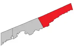 Location within Saint John County. map erroneously shows Saint John as part of Simonds Parish | |
| Coordinates: 45.36°N 65.54°W | |
| Country | |
| Province | |
| County | Saint John County |
| Erected | 1786 |
| Area | |
| • Land | 629.20 km2 (242.94 sq mi) |
| Population (2016)[1] | |
| • Total | 1,132 |
| • Density | 1.8/km2 (5/sq mi) |
| • Change 2011-16 | |
| • Dwellings | 609 |
| Time zone | UTC-4 (AST) |
| • Summer (DST) | UTC-3 (ADT) |
| Median Income* | $53,675 CDN |
| |
For governance purposes it is divided between the village of St. Martins and the local service district of the parish of Saint Martins,[3] both of which are members of the Fundy Regional Service Commission (FRSC).[4]
Origin of name
Ganong omitted Saint Martins.[5]
The Provincial Archives of New Brunswick gives only a possibility - St. Martins, Maryland,[6] which could refer to either Saint Martin or Saint Martins by the Bay,[7] both in Worcester County, Maryland.
History
Saint Martins was erected in 1786 as one of the county's original parish.[8]
In 1837 the eastern end of Saint Martins was transferred to Westmorland County.[9] The lost area is now part of Alma Parish in Albert County.
Delineation
Saint Martins Parish is defined in the Territorial Division Act[2] as being bounded:
- All that part of the County lying to the eastward of Simonds Parish.
Communities
Parish population total does not include incorporated municipalities (in bold).
|
|
|
Bodies of water & Islands
This is a list of rivers, lakes, streams, creeks, marshes and Islands that are at least partially in this parish
- Salmon River
- Tynemouth Creek
Demographics
Population
|
LanguageMother tongue (2016)[1]
|
Access Routes
Highways and numbered routes that run through the parish, including external routes that start or finish at the parish limits:[11]
|
|
|
|
See also
References
- "Census Profile, 2016 Census Saint Martins, Parish [Census subdivision], New Brunswick". Statistics Canada. Retrieved September 29, 2019.
- "Chapter T-3 Territorial Division Act". Government of New Brunswick. Retrieved 13 November 2020.
- "New Brunswick Regulation 84-168 under the Municipalities Act (O.C. 84-582)". Government of New Brunswick. Retrieved 22 July 2020.
- "Communities in each of the 12 Regional Service Commissions (RSC) / Les communautés dans chacune des 12 Commissions de services régionaux (CSR)" (PDF), Government of New Brunswick, July 2017, retrieved 2 February 2021
- Ganong, William F. (1896). A Monograph of the Place-Nomenclature of the Province of New Brunswick. Royal Society of Canada.
- "Saint Martins Parish". Provincial Archives of New Brunswick. Retrieved 23 October 2020.
- United States Geographic Service
- "26 Geo. III Chapter I. An Act for the better ascertaining and confirming the Boundaries of the several Counties within this Province, and for subdividing them into Towns or Parishes.". Acts of the General Assembly of His Majesty's Province of New-Brunswick, passed in the year 1786. Saint John, New Brunswick: Government of New Brunswick. 1786. pp. 3–12.
- "7 Wm. IV c. 35 An Act to establish a Boundary Line between the Counties of Westmorland and Saint John, and King's and Queen's Counties.". Acts of the General Assembly of His Majesty's Province of New Brunswick, Passed in the Year 1837. Fredericton: Government of New Brunswick. 1837. pp. 91–92.
- Statistics Canada: 1986, 1991, 1996, 2001, 2006, 2011, 2016 census
- Atlantic Canada Back Road Atlas ISBN 978-1-55368-618-7
Places adjacent to Saint Martins Parish, New Brunswick | ||||||||||
|---|---|---|---|---|---|---|---|---|---|---|
| ||||||||||
| Subdivisions | |
|---|---|
| Cities | |
| Counties | |
| |