Hammond Parish, New Brunswick
Hammond is a civil parish in Kings County, New Brunswick, Canada.[2]
Hammond | |
|---|---|
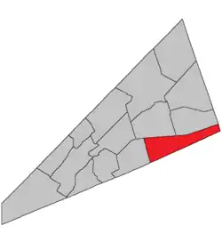 Location within Kings County, New Brunswick. | |
| Coordinates: 45.84°N 64.59°W | |
| Country | |
| Province | |
| County | Kings County |
| Erected | 1858 |
| Area | |
| • Land | 244.45 km2 (94.38 sq mi) |
| Population (2016)[1] | |
| • Total | 251 |
| • Density | 1.0/km2 (3/sq mi) |
| • Change 2011-2016 | |
| • Dwellings | 153 |
| Time zone | UTC-4 (AST) |
| • Summer (DST) | UTC-3 (ADT) |
The local service district is a member of Regional Service Commission 8 (RSC8).[3]
Origin of name
The parish was named for the Hammond River, which in turn took its name from Sir Andrew Snape Hamond, former Governor of Nova Scotia, who received a land grant on the river in 1787.[4]
History
Hammond was erected in 1858 from the eastern part of Upham Parish.[5]
In 1875 the boundary with Sussex and Waterford Parishes was adjusted.[6]
Delineation
Hammond Parish is defined in the Territorial Division Act[2] as being bounded:
- Northerly by Sussex and Waterford Parishes; south and east by the County lines, and west by Upham Parish.
Governance
The entire parish forms the local service district of the parish of Hammond, established in 1968 to assess for fire protection. First aid and ambulance services were added to the assessment in 1972. Recreational facilities were added to the assessment in 1994, with first aid and ambulance services being removed at the same time.
Communities
Parish population total does not include incorporated municipalities (in bold):
|
|
Bodies of water & Islands
This is a list of rivers, lakes, streams, creeks, marshes and Islands that are at least partially in this parish
Demographics
Access Routes
Highways and numbered routes that run through the parish, including external routes that start or finish at the parish limits:[9]
See also
References
- "Census Profile, 2016 Census: Hammond, Parish [Census subdivision], New Brunswick". Statistics Canada. Retrieved September 19, 2019.
- "Chapter T-3 Territorial Division Act". Government of New Brunswick. Retrieved 13 November 2020.
- "Communities in each of the 12 Regional Service Commissions (RSC) / Les communautés dans chacune des 12 Commissions de services régionaux (CSR)" (PDF), Government of New Brunswick, July 2017, retrieved 2 February 2021
- Ganong, William F. (1896). A Monograph of the Place-Nomenclature of the Province of New Brunswick. Royal Society of Canada. p. 239.
- "21 Vic. c. 40 An Act to authorize the division of the Parish of Upham into two Parishes.". Acts of the General Assembly of Her Majesty's Province of New Brunswick, Passed in March and April 1858. Fredericton: Government of New Brunswick. 1858. pp. 90–91.
- "38 Vic. c. 114 An Act to establish the division line between the Parish of Hammond and the Parishes of Sussex and Waterford, in King's County.". Acts of the General Assembly of Her Majesty's Province of New Brunswick. Passed in the Month of April 1875. Fredericton: Government of New Brunswick. 1875. pp. 388–389.
- Statistics Canada: 2001, 2006 census
- 2011 Statistics Canada Census Profile: Hammond Parish, New Brunswick
- Atlantic Canada Back Road Atlas ISBN 978-1-55368-618-7
Places adjacent to Hammond Parish, New Brunswick | ||||||||||
|---|---|---|---|---|---|---|---|---|---|---|
| ||||||||||
| Subdivisions | |
|---|---|
| Cities | |
| Counties | |
| |