Banks Peninsula
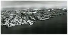
Banks Peninsula is a peninsula of volcanic origin on the east coast of the South Island of New Zealand. It has an area of approximately 1,150 square kilometres (440 sq mi) and encompasses two large harbours and many smaller bays and coves. The South Island's largest city, Christchurch, is immediately north of the peninsula.

Geology
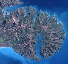
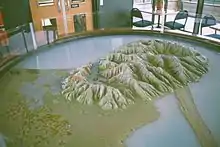
Banks Peninsula forms the most prominent volcanic feature of the South Island, similar to — but more than twice as large as — the older Dunedin volcano (Otago Peninsula and Harbour) 350 kilometres (220 mi) to the southwest. Geologically, the peninsula comprises the eroded remnants of two large composite shield volcanoes (Lyttelton formed first, then Akaroa), and the smaller Mt Herbert Volcanic Group.[1] These formed due to intraplate volcanism between approximately eleven and eight million years ago (Miocene) on a continental crust. The peninsula formed as offshore islands, with the volcanoes reaching to about 1,500 m above sea level. Two dominant craters formed Lyttelton and Akaroa Harbours.
The Canterbury Plains formed from the erosion of the Southern Alps / Kā Tiritiri o te Moana (an extensive and high mountain range caused by the meeting of the Indo-Australian and Pacific tectonic plates) and from the alluvial fans created by large braided rivers. These plains reach their widest point where they meet the hilly sub-region of Banks Peninsula. A layer of loess, a rather unstable fine silt deposited by the foehn winds which bluster across the plains, covers the northern and western flanks of the peninsula. The portion of crater rim lying between Lyttelton Harbour and Christchurch city forms the Port Hills.
Prehistory
According to tradition the first Māori settlers of the area now known as Banks Peninsula were the Waitaha led by their founding ancestor Rākaihautū. The Māori name for the peninsula is Te Pataka o Rākaihautū (The Storehouse of Rākaihautū) in recognition of his deeds and the abundance of mahinga kai (foods of the forests, sea, rivers and skies). They were followed by Kāti Māmoe, and then the Ngāi Tahu hapu Ngāi Tūhaitara, who arrived in the 1730s.[2]
History
The first European sighting of the peninsula was on 17 February 1770 by Captain James Cook and crew during Cook's first circumnavigation of New Zealand. Cook described the land as "of a circular figure ... of a very broken uneven surface and [having] more the appearance of barrenness than fertility."[3] Deceived by the outline of higher land behind the peninsula, Cook mistook it for an island and named it "Banks Island" in honour of Endeavour's botanist, Joseph Banks.[3] Distracted by a phantom sighting of land to the southeast, Cook then ordered Endeavour away to the south without exploring more closely. 1n 1809 Captain Samuel Chase corrected Cook's charts by determining that "Banks Island" was in fact a peninsula.[4]
In 1830 the Māori settlement at Takapūneke was sacked, and the local Ngāi Tahu chief, Tama-i-hara-nui captured, by Ngāti Toa chief, Te Rauparaha, with the assistance of the captain of the British brig Elizabeth, John Stewart.[5] It was partly as a result of this massacre that the British authorities sent James Busby, as official British Resident, to New Zealand in 1832.[5]
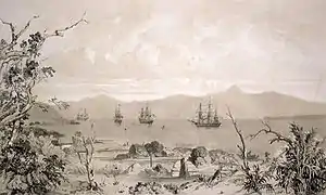
During the 1830s several European whaling bases were established on Banks Peninsula. In 1838 Captain Langlois, a French whaler, decided that Akaroa would make a good settlement to service whaling ships and "purchased" the peninsula in a dubious land deal with the local Māori.[6] He returned to France, floated the Nanto-Bordelaise company, and set sail for New Zealand with a group of French and German families aboard the ship Comte de Paris, with the intention of forming a French colony on a French South Island of New Zealand. By the time Langlois and his colonists arrived at Banks Peninsula in August 1840, many Māori had already signed the Treaty of Waitangi (the signatories including two chiefs at Akaroa in May) and New Zealand's first British Governor, William Hobson, had declared British sovereignty over the whole of New Zealand. On hearing of the French plan for colonisation, Hobson quickly dispatched HMS Britomart from the Bay of Islands to Akaroa with police magistrates on board.[7] While Langlois and his colonists sheltered from unfavourable winds at Pigeon Bay on the other side of the peninsula, the British raised their flag at Greens Point between Akaroa and Takapūneke and courts of law convened to assert British sovereignty over the South Island.
From the 1850s, Lyttelton and then Christchurch outgrew Akaroa, which is now a holiday resort and cruise ship destination and has retained many French influences as well as many of its nineteenth-century buildings.
Historic harbour defence works dating from 1874 onwards survive at Ripapa Island in Lyttelton Harbour, and at Godley Head.
In 2011, the Christchurch earthquakes of Feb and June had their epicentres in the Port Hills, significantly affecting communities.
Economy
Fisheries
Several sites off the coast of the peninsula serve for mariculture cultivation of mussels.
Farming
Farming has been a traditional industry on Banks Peninsula.
Tourism
Following the major earthquakes of 2010 and 2011, which affected Christchurch and Lyttelton (the harbour serving Christchurch), cruise ships were diverted to Akaroa Harbour.
Summit Road
The Summit Road forms a notable feature on the peninsula. Built in the 1930s, the road is in two sections (both of which have views of the area, as well as parks, walkways, and other recreational features):
- one section runs along the crest of the Port Hills from Godley Head (the northern head of Lyttelton Harbour) to Gebbies Pass at the head of the harbour
- the other section runs around the crater rim of Akaroa Harbour from 'Hill Top' – the junction with the main Christchurch-Akaroa highway – to a point above Akaroa.
Conservation
Estimates suggest that native forest once covered 98% of the peninsula. However, Māori and European settlers successively denuded the forest cover and less than 2% remains today, although some reforestation has started. European settlers have planted many English trees, notably walnut.
Hinewai Reserve
Hinewai Reserve, a private nature reserve, has been established on the peninsula to allow for native forest to regenerate on land that was once farmed. It was established in 1987 and now spans 1250 hectares of native bush.[8] it has 40 km of walking tracks through the native bush.[9]
Other protected areas on the peninsula include Ellangowan Scenic Reserve (3.14 km²), designated in 1973, Mount Herbert Scenic Reserve (2.42 km²), designated in 1980, Wairewa Stewardship Area (6.51 km²), designated in 1987, and Palm Gully Scenic Reserve (1.11 km²), designated in 1989.[10]
Marine Reserves
A large Marine Mammal Sanctuary, mainly restricting set-net fishing, surrounds much of the peninsula. This has the principal aim of the conservation of Hector's dolphin, the smallest of all dolphin species. Eco-tourism based around the playful dolphins has now become a significant industry in Akaroa.
The relatively small Pohatu Marine Reserve centres on Flea Bay on the south-east side of the peninsula and the larger Akaroa Marine Reserve lies at the entrance to the Akaroa Harbour.
Rod Donald Banks Peninsula Trust
The Rod Donald Banks Peninsula Trust aims to improve public walking and biking access and enhance biodiversity on Banks Peninsula. They (in 2020) are raising money to purchase 500ha of land including the summits of Mt Herbert/ Te Ahu Patiki and Mt Bradley with the intention to set up a conservation park protecting and restoring native biodiversity.[8] The land is currently farmland but over time the trust intends to return it to native bush.They are also involved in developing Te Ara Pātaka, also known as the Summit Walkway. They have also been involved in providing tramping huts (Rod Donald Hut and Otamahua Hut on Quail Island) for the public to access.[11]
Banks Peninsula Conservation Trust
The Banks Peninsula Conservation Trust was formed in 2001. It works to conserve and enhance the biodiversity and encourage sustainable land management on Banks Peninsula. Work being undertaken in 2020 included work to protect moreporks and tuis. They also work with landowners to legally protect important biodiversity and landscape values in perpetuity through covenants.[12]
Towns
Akaroa
Akaroa is a small town on the edge of the Akaroa harbour.
Little River
Little River is a small town which sits at the end of the Little River Rail Trail. There are several art galleries, a camp ground, rugby club and primary school there. The area is known to Māori as Wairewa.
Wainui
Wainui is a settlement of mostly holiday houses on the Akaroa harbour.
Duvauchelle
Duvauchelle is a small town which sits at the head of the Akaroa harbour.
Bays
Taylors Mistake
Taylors Mistake is a Christchurch swimming beach with a number of holiday houses lining the bay.
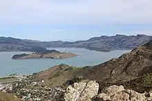
Lyttelton Harbour
Lyttelton Harbour is a harbour within Banks Peninsula. Within the harbour lies Quail Island.
Port Levy
Port Levy is the most north facing of the bays on Banks Peninsula. It has been visited by Europeans since the 1820s and known as Koukourarata in Maori.[13][14]
Pigeon Bay
Pigeon Bay has a walking track which follows the eastern side of Pigeon bay out to the head of the bay. It takes about 4 or 5 hours to walk there and back. It has spectacular coastal views.[15] There are a number of holiday homes in Pigeon bay as well as a yacht club.
Little Akaloa
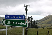
Little Akaloa is named "little" to distinguish it from Akaroa. It was spelt Hakaroa until 1864.[16] Feral goats have been a problem in Little Akaloa but a successful cull of them in early 2019 is helping eradication efforts on Banks Peninsula.[17]
A moonfish (150 cm long) washed up on the beach at Little Akaloa in 2013. They are more commonly found further north.[18]
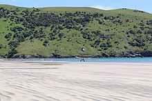
Farming around Little Akaloa is a mainstay of the economy.[19] with accommodation providers being a second.[20] Camping at the Little Akaloa Domain is popular in summer. The beach has a boat ramp.
Okains Bay
Okains Bay has a holiday camp ground and a large sandy beach.
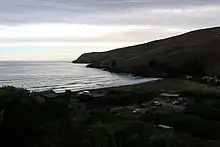
Le Bons Bay
Le Bons Bay has a large often empty beach. There is a small settlement of holiday houses. It is surrounded by rolling hills. A river empties into the sea where New Zealand Fur Seals often frolic.[21]
Hickory Bay
Hickory Bay is known as having a beach that provides good surfing.[22][23] It is east facing. It is known in Maori as Waikerikikari, the Bay of Angry Waters, and was never permanently settled by the Māori.[24]
The Ellangowan Scenic Reserve walk is located just below the Summit road in Hickory Bay.
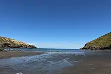
Pohatu / Flea Bay
Pohatu / Flea Bay has large colonies of penguins and seals living there,[25] It is home to the Pohatu Marine Reserve.[26] The Marine Reserve is home to many fish species including triplefins, lumpfish, moki, butterfish, spotties, banded wrasse, blue cod, leather jackets, lobsters, paua and rockfish.[27]
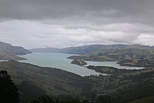
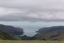
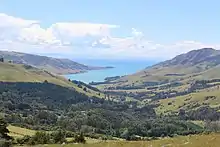
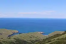
Akaroa Harbour
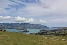
Akaroa Harbour is one of the two large harbours on Banks Peninsula. The other being Lyttelton Harbour.
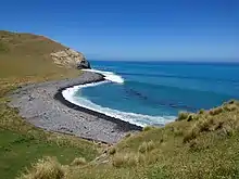
Tumbledown Bay
Tumbledown Bay is considered one of the best beaches near Christchurch. Most people are put off by the drive to get there, hence it is usually very quiet.[21]
Te Oka Bay
Magnet Bay
Magnet Bay is known as a spot to go surfing. It has an exposed reef and point break. These provide reasonably consistent surf all year around.[28]
Walking tracks
Banks Peninsula Track
An attraction for trampers and bushwalkers is the Banks Peninsula Track. There are opportunities to see penguins, falcons, geckos, and sooty shearwater while walking the track. The track can be completed over two to three days. The 31 km circular route starts in Akaroa and visits Flea Bay, Stony Bay and Hinewai Reserve.[29]
Te Ara Pataki (Summit walkway)
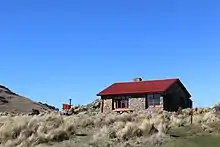
The Te Ara Pataki (Summit walkway) is a three day tramp that can start at multiple places. The longest routes start either at Gebbies Pass or Kaituna Valley and go to Sign of the Packhorse Hut on the first day. On the second day, trampers follow a track crossing just below Mount Bradley (855m) and then ascend Mount Herbert (919m) before descending to the Port Levy Saddle. From here it is a short walk to the second overnight stay at Rod Donald Hut. The third day takes in Mount Fitzgerald (826m) and Mount Sinclair (841m). The track then descends past a 2000 year old giant tōtara in Montgomery Park Scenic Reserve before finishing near the Hilltop tavern on state highway 75.[30][31]
Le Race
The annual 100 km road cycling race from Cathedral Square in Christchurch to Akaroa traverses the Banks Peninsula. The course climbs up Dyers Pass road, follows the summit road along the Port Hills before descending Gebbies Pass to State highway 75. It then ascends to Hilltop before turning off and following the summit road, climbing Duvauchelle peak and descending Long Bays Road into Akaroa. It has been won by three times by Mark Bailey, twice by Michael Vink, Jeremy Yates and Daniel Whitehouse. Hayden Roulston (2016) and Brian Fowler (2005 ) have also won it.[32] In the women's competition Jo Buick, Reta Trotman and Sharlotte Lucas have all won it three times.[32]
Statistics
- Highest point: Mount Herbert / Te Ahu Pātiki 919 metres (3,015 ft)[33]
- Permanent population: 7600
References
- Hampton, S.J.; J.W. Cole (March 2009). "Lyttelton Volcano, Banks Peninsula, New Zealand: Primary volcanic landforms and eruptive centre identification". Geomorphology. 104 (3–4): 284–298. Bibcode:2009Geomo.104..284H. doi:10.1016/j.geomorph.2008.09.005.
- Tau, Te Maire (1 March 2017). "Ngāi Tahu – The move south". Te Ara – the Encyclopedia of New Zealand. Retrieved 25 December 2020.
- Beaglehole, J.C., ed. (1968). The Journals of Captain James Cook on His Voyages of Discovery, vol. I:The Voyage of the Endeavour 1768–1771. Cambridge University Press. pp. 253–257. OCLC 223185477.
- Entwisle, Peter (2005). Taka: a vignette life of William Tucker 1784–1817. Port Daniel Press. p. 49. ISBN 0-473-10098-3. Retrieved 19 August 2010.
- "A frontier of chaos? Page 5 – Captain Stewart and the Elizabeth". New Zealand History. Retrieved 25 December 2020.
- "French colonists in Akaroa, South Island". New Zealand in History. Retrieved 23 May 2018.
- Andersen, Johannes C. "The Mission of the Britomart at Akaroa, in August, 1840" (PDF). The New Zealand Institute. Retrieved 23 May 2018.
- "Banks Peninsula to become home to new 500ha conservation park". Stuff. 29 October 2020. Retrieved 21 December 2020.
- "The kaitiaki who's spent over 30 years reforesting a Banks Peninsula reserve". Stuff. 1 September 2019. Retrieved 21 December 2020.
- UNEP-WCMC (2020). Protected Area Profile for New Zealand from the World Database of Protected Areas, October 2020. Available at: www.protectedplanet.net
- "Projects Landing Page « Rod Donald Trust". Retrieved 21 December 2020.
- "Covenants". www.bpct.org.nz. Retrieved 21 December 2020.
- "'Heaven' in Koukourārata". Te Rūnanga o Ngāi Tahu. Retrieved 21 December 2020.
- "The Red Rocks Of Te Ngarara – Port Levy". Discover The Delights Of Peeling Back History. 27 February 2013. Retrieved 21 December 2020.
- "Pigeon Bay Walkway". www.doc.govt.nz. Retrieved 21 December 2020.
- "Little Akaloa | NZHistory, New Zealand history online". nzhistory.govt.nz. Retrieved 21 December 2020.
- "Wild goats on Canterbury's Banks Peninsula in the crosshairs". Stuff. 25 October 2019. Retrieved 21 December 2020.
- "'Huge' fish attracts attention in Little Akaloa". Stuff. 28 January 2013. Retrieved 21 December 2020.
- "Business and farming combine in environmental care". Stuff. 1 May 2015. Retrieved 21 December 2020.
- "Living large in a tiny home in Little Akaloa". Stuff. 5 May 2019. Retrieved 21 December 2020.
- "Christchurch's hidden beach gems, in time for summer". Stuff. 13 December 2018. Retrieved 21 December 2020.
- "Hickory Bay | Surf Seeker | NZ Surf Guide". surfseeker.nz. Retrieved 21 December 2020.
- "Banks Peninsula – Hickory Bay Surf Forecast and Surf Reports (Canterbury, New Zealand)". www.surf-forecast.com. Retrieved 21 December 2020.
- "Waikerikikari — Hickory Bay". my.christchurchcitylibraries.com. Retrieved 21 December 2020.
- "Banks Track: Is this New Zealand's best-kept walking secret?". NZ Herald. Retrieved 21 December 2020.
- "Pohatu Marine Reserve". www.doc.govt.nz. Retrieved 21 December 2020.
- "Pohatu Marine Reserve | Christchurch – Canterbury, New Zealand". www.newzealand.com. Retrieved 21 December 2020.
- "Banks Peninsula – Magnet Bay Surf Forecast and Surf Reports (Canterbury, New Zealand)". www.surf-forecast.com. Retrieved 21 December 2020.
- "Banks Track – Banks Peninsula, NZ – An Eco-Tourism Experience". Banks Peninsula Track Limited. Retrieved 20 December 2020.
- "Greater Banks Peninsula Walks". Banks Peninsula Walks. Retrieved 20 December 2020.
- "Te Ara Pātaka/Summit Walkway". www.doc.govt.nz. Retrieved 20 December 2020.
- Events, Tailwind. "Hall of Fame". Le Race. Retrieved 21 December 2020.
- "Banks Peninsula tramping tracks". Department of Conservation. Retrieved 19 June 2017.
Further reading
- Laing, Robert (1919). "The Vegetation of Banks Peninsula, with a List of Species (Flowering-plants and Ferns)". Transactions and Proceedings of the Royal Society of New Zealand. New Zealand Institute. 51.
- Wilson, Hugh D (2009). Natural History of Banks Peninsula. Christchurch, N.Z: Canterbury University Press. ISBN 978-1-877257-82-7.
External links
| Wikimedia Commons has media related to Banks Peninsula. |
- Banks Peninsula District census results: 2001, 1996
- Map of Banks Peninsula ward, Christchurch