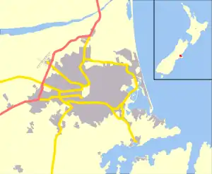
Sumner, New Zealand
Sumner is a coastal seaside suburb of Christchurch, New Zealand and was surveyed and named in 1849 in honour of John Bird Sumner, the then newly appointed Archbishop of Canterbury and president of the Canterbury Association. Originally a separate borough, it was amalgamated with the city of Christchurch as communications improved and the economies of scale made small town boroughs uneconomic to operate.
Sumner | |
|---|---|
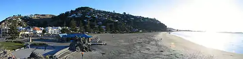
 Looking down on Sumner (left) from Scarborough | |
 Sumner | |
| Coordinates: 43.57144°S 172.76447°E | |
| Area | |
| • Total | 9.3178 km2 (3.5976 sq mi) |
| Population (2006) | |
| • Total | 3,978 |
| • Density | 430/km2 (1,100/sq mi) |
Toponymy
.jpg.webp)
Captain Thomas named the settlement for Bishop John Bird Sumner, one of the leading members of the Canterbury Association.[1]
The Ngai Tahu name for the beach between Cave Rock (Tuawera) and Scarborough is Matuku Tako Tako.[2][1] This name has been used by both the state primary school and the city libraries.
A. W. Reed gives the Māori name for the area is Ohikaparuparu ("o" means place of; "hika" means rubbing, kindling, or planting; "paruparu" means dirt, deeply laden, or a preparation of fermented cockles).[3] However, J. F Menzies indicates this name is associated with a settlement on the shores of the estuary between Redcliffs and Mt Pleasant and prefers an alternative translation of "The place where sticks were rubbed together to make a fire with which to cook cockles in preparation for a journey".[4] Andersen places this name on the beach at the mouth of the estuary, near Shag Rock (Rapanui).[2] James Cowan, retelling Sir Maui Pomare, indicates this name applies to the estuary shallows and means "fall in the mud".[5]
History

Sumner was surveyed in 1849 by Edward Jollie for Captain Joseph Thomas, the advanced agent of the Canterbury Association. Jollie's November 1849 map showed 527 sections and numerous reserved and provisions for churches, schools, cemeteries, town hall, emigration barracks and other town amenities. However, his plans were abandoned through lack of funds and a new survey on which Sumner is based was carried out in 1860.
The first European to carry out work in Sumner is believed to be Charles Crawford, a whaleboat owner, who transported materials from Port Cooper, now Lyttelton, under contract to build the headquarters and storeroom for Captain Thomas. Sumner was settled in late 1849 or early 1850 by work crews building the road to Lyttelton, Sumner is thus one of the oldest European settlements in the Christchurch area. The Day family was the first to settle permanently in Sumner followed by Edward Dobson and his family.

Sumner had its first shop early in 1870, and its proprietor, S.E. Horneman, was postmaster from 1873 until 1876.
In 1872, it came under the control of the Heathcote Road District. When provincial councils were disestablished in 1876 and replaced with counties, Sumner had a second parent body, the Selwyn County added to the continuing road board.[6] In 1883, Sumner was constituted as a town district and was run by a board of five elected commissioners.[7] The board elected its own chairmen, and the two people who filled that role were C. L. Wiggins (March 1883 – September 1884) and J. M. Wheeler (September 1884 – June 1891).[8] On 1 June 1891, Sumner was proclaimed a borough.[9] Mayoral elections were held on 27 June, and the last chairman was elected the first Mayor of Sumner.[10]
In 1885 the Harbour Board granted the concession to build a bath at the East end of Sumner beach. S.L. Bell enclosed some of the sea, built dressing sheds and a tea shop. The bathing pool was a great attraction but every year terrific storms would batter the bath and gradually dump fine sand. Eventually a flood filled the bath with clay and silt from the hills causing its closure.
In 1912 Sumner established its own gasworks and electricity was connected in 1918.[11] The Anglican evangelical leader William Orange was vicar of Sumner from 1930–1945.[12]
On 22 February 2011, Sumner was hit by the Christchurch earthquake, which destroyed or made uninhabitable a large number of the local houses and commercial buildings. On 13 June the same year, Sumner was hit by another earthquake of almost the same magnitude as the February event. These two earthquakes caused many of Sumner's iconic cliffs to collapse, and many areas to be cordoned off with both traditional fences and shipping containers.
Geography
Sumner is nestled in a coastal valley separated from the adjacent city suburbs by rugged volcanic hill ridges that end in cliffs that descend to the sea shore in places. Sumner Bay is the first bay on the northern side of Banks Peninsula and faces Pegasus Bay and the Pacific Ocean.
Because of its ocean exposure, a high surf can form in some swell conditions. The beach is gently sloping, with fine grey sand. It is a popular surf beach for these reasons.
Sand dunes have filled the river valley behind the beach. This has made housing construction relatively easy, although flooding at the head of the valley has been a problem in the past due to the reverse slope caused by the sand dunes filling the front of the valley. This has been addressed by a flood drain.
A sea wall and wide esplanade have been built along the length of the beach to prevent coastal erosion.
The rocky volcanic outcrop of Cave Rock, or Tuawera dominates the beach.[13] Until the mid-1860s, this feature was known by Europeans as Cass Rock, after the surveyor Thomas Cass.[14] There are other rocky outcrops in the area and the volcanic nature of the geology is readily apparent from several of the exposed cliffs around the valley.
Shag Rock, or Rapanui, is another large volcanic outcrop at the western end of the beach and sits at the mouth of the Estuary formed by the Avon and Heathcote rivers.[15] This landmark was shattered by the Christchurch earthquakes in 2011, which reduced the iconic rock to a pile of boulders.[15]
Sumner bar
The Sumner Bar is a sand bar where the estuary meets the sea and is notoriously dangerous to cross.[16][17] The outlet of the Avon Heathcote Estuary, at the western end of the beach, forms the Sumner bar off shore of Cave Rock. The Sumner bar presents a major hazard to shipping, while the fast currents, strong rips and undertows in the area can be a danger to swimmers.
In December 1854, Commander Byron Drury, in HMS Pandora, surveyed the Sumner Bay, including the bar and mouth of the Avon-Heathcote Estuary for the Canterbury Provincial Council. Drury wrote a report and produced a detailed chart of the area, with soundings.[18] Commander Drury's 1854 chart locates several buildings on shore, including a store at the foot of the hill in Clifton Bay, Day's house, which is set well back from the foreshore on a bend in the road, as it turns away from the foot of Clifton hill, and Dobson's house, which is shown at end of the spur at the foot of Richmond Hill. Compared to a modern-day map, the Day's house would have been near the corner at the top end of Nayland Street while Dobson's house would be near the intersection of Nayland Street and Wakefield Avenue.
The earliest recorded accident crossing the Sumner Bar occurred in May 1845 when a whaleboat capsized, without loss of life.[17] The earliest recorded loss of life was in 1851 when a dinghy capsizes and two men aboard drowned.[19] The cutter Hawk broke up crossing the Sumner Bar in rough weather at the end of June 1851 and wrecked on the beach, though the crew survived, the cargo was plundered.[20] Fifteen more vessels were recorded as stranding on the bar between 1851 and 1867, with 7 being total losses.[17][21]
One regular vessel crossing the bar in the early days was the Mullogh, New Zealand's first iron hulled steamer. On 25 August 1865 the Mullogh ran onto Cave Rock, Sumner, in violent surf. Her cargo of liquor created keen interest on the beach. George Holmes of Pigeon Bay, the contractor for the Lyttelton Rail Tunnel, then bought the ship, refitted and used her until 1869.[22][21]
The NZ Trawler Muriel was stranded on Sumner Beach in 1937 and was a total loss and had to be dismantled where she lay.[21]
Community
Sumner is a focal point for the adjacent suburbs of Clifton, Richmond Hill and Scarborough. In earlier times, residents of those suburbs would often have been considered to be living in Sumner, because these suburbs have road access via Sumner or depend on services available in Sumner. Before 1945, Sumner was a separate borough from Christchurch City. Also, before seven-digit landline telephone numbering was implemented in Christchurch (late 1980s or early 1990s), telephone subscribers in these suburbs would have had a four-digit Sumner telephone exchange number.
Government

Sumner is administered by the Christchurch City Council.
The Canterbury Association initially administered Sumner, with the valley being surveyed by Edward Jollie in 1849 and he drew up a street plan in November of that year. However, the planned settlement was rejected by Godley and the land was not subdivided. When the first allocation of rural sections was made public in February 1851, rural section No.2 was allocated to Felix Wakefield.[23] This section was bounded in the North by a road along the coast, in the West by the road between Christchurch and Lyttelton, by an accommodation road against the hillside in the East and another accommodation road across the valley in the South.[23][24] The street names on the 1850 settlement plan were not used and Wakefield subdivided and leased or sold off parts of this rural section in smaller lots to create a settlement he called Wakefield Township.
After the Canterbury Association was disestablished, Sumner came under the control of the Canterbury Provincial Council. This lasted until the provinces were disestablished in 1876 and county councils were established instead. Sumner came under the jurisdiction of the Selwyn County Council initially.
A Town Board was established during the 1870s.
By the end of the 1880s Sumner had become a borough and administered the still mostly rural suburbs east of Ferrymead, including Mount Pleasant, Redcliffs, Moncks Bay, Clifton and Richmond Hill as well as the mostly undeveloped land between Scarborough and Godley Head, including Taylors Mistake.
By the 1940s, small town boroughs were becoming uneconomic and Sumner was merged with Christchurch city.
Culture and Heritage
Architecture
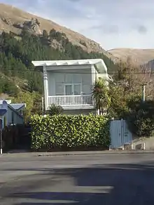
The Pascoe House in Colenso Street is a category II historic place and an early example of a two story private dwelling in the Post War Modern Domestic style of the 1940-1960. It was designed by architect Paul Pascoe and constructed in 1948 as his own private home.[25]
Transport
The need for a convenient route between the Port at Lyttelton and the plains settlement of Christchurch was quickly recognised by Captain Thomas, Chief Surveyor for the Canterbury Association. Settlement of flat land at Sumner was also planned at an early stage.
By sea
The Sumner Bar is a notable navigation hazard, though it can be crossed safely in the right wind, tide and sea conditions. However, with an exposed coast and no safe anchorage immediately off-shore, good seamanship is also required.[26]
There is a small boat harbour, protected by a substantial breakwater, at the south-eastern end of Sumner Bay, below Scarborough. There is a slipway for launching small boats from a trailer, as well as the lifeboat station. However, the area has a tendency to silt up, as it is still exposed to wind and sea.
In 1849, this area was known as Sumner Nook and was the only comparatively safe place in the bay for landing from a boat, because of a lagoon formed by a small stream running into the sea in this area. But, with Sumner Bay open to the Pacific Ocean, there was no nearby safe anchorage for larger ships, short of Lyttelton Harbour, about 8 nautical miles away by sea. An early proposal, by Captain Thomas, was to builds a jetty here to unload ships and transport the cargo by tramway to the estuary beyond Shag Rock, to avoid ships having to cross the Sumner Bar, but a land option was chosen instead.
By land
A convenient land route between Lyttelton to Christchurch has been a requirement from the beginning of Canterbury settlement. While rail and road tunnels between Lyttelton to Christchurch have been constructed, there remains the need to transport goods that are too dangerous or too large to travel through one of the tunnel. The route via Sumner remains a necessary transport alternative.
Construction of a road from Lyttelton to Christchurch via Evans Pass and Sumner began in 1849. However, progress was slow due to steep hillsides and hard volcanic rock being encountered. In 1850, a Bridle Path was cut directly over the saddle between Lyttelton and the Heathcote Valley so that the early settlers could travel to Ferrymead by foot and pack horse, while their heavy goods still needed to be transported across the Sumner Bar by boat. Road construction on the western side of the Sumner valley ceased in 1851 when construction encountered steep volcanic bluffs and funds ran out. The original road line, now known as Captain Thomas' Track, was abandoned and a new way down the eastern side of the valley between Evans Pass and Sumner was subsequently found and constructed.
Public transport
A tramway opened to Sumner on 1 November 1888.
Education
Sumner School
Sumner School was founded in 1876 and is these days a full primary school, teaching children from years 1 to 8. The school has, as of 2011, a roll of 435 pupils and is decile 10.[27][28]
Star of the Sea School
The Star of the Sea School is a Catholic full primary school, teaching children from years 1 to 8. In 2011, the school has a roll of 121 pupils and is decile 10.[29][30]
van Asch Deaf Education Centre
The van Asch Deaf Education Centre takes hearing-impaired children from all over the South Island and the southern North Island. Apart from the Sumner campus, it operates satellite classrooms at Sumner School and at Linwood High School. In 2011, the school has a roll of 28 pupils and is decile 4.[31][32]
Sumner Life Boat Institution

Because of the hazard posed by the Sumner Bar, Sumner has had a lifeboat of some kind almost since its settlement. There is no record of a formal or even informal lifeboat being available prior to the appointment of a pilot in September 1864. However, it is likely that small open rowing boats were available in the bay from the early 1850s.
The Sumner Life Boat Institution has operated a formal life boat or similar rescue craft in the bay since 1898. The traditional name of Rescue has been applied to three of the life boats.
Notable people
- Rita Angus (1908–1970), painter
- Edward Dobson (1816/17? – 1908), early landowner and resident
- Ruth France (1913–1968), librarian, poet and novelist
- Denis Glover (1912–1980), poet and publisher
- William M. Hodgkins (1833–1898), painter
- William Orange (1889–1966), Anglican clergyman
- Samuel Hurst Seager (1855–1933), draftsman and architect who had a subdivision of eight houses built on Clifton Spur
- Petrus Van der Velden (1837–1913), Dutch-born painter and lithographer
- Felix Wakefield (1807–1875), first landowner
Notes
- Amodeo, Colin, ed. (1998). Rescue, The Sumner community and its lifeboat service. Sumner, Christchurch, New Zealand: Sumner Lifeboat Institute Incorporated. p. 1. ISBN 0-473-05164-8.
- Andersen, Johnannes C. (1927). "Map of Banks Peninsula showing principal surviving European and Maori place-names 1927". Wellington: Govt. Print. Retrieved 22 December 2020.
- Reed, A. W. (2010). Peter Dowling (ed.). Place Names of New Zealand. Rosedale, North Shore: Raupo. p. 379. ISBN 978-0-14-320410-7.
- Menzies, J. F. (1941). "Sumner" (PDF). Digital Collection, Christchurch City Libraries. p. 34. Retrieved 20 December 2020.
- Cowan, James (1987). "EPISODE III. THE LAUNCHING OF THE SPELL". LEGENDS OF THE MAORI. Wellington: Southern Reprints. Retrieved 22 December 2020.
And the dwellers in the riverbank pa, Pohoareare, men, women and children, launched their canoes and paddled down the slow Opaawaho, across the shallows of Ohikaparuparu, or, literally, “Fall-in-the-mud,” and so out past the black, tooth-like rock of Rapanui to the firm beach sands, where Sumner township stands to-day.
- Menzies 1941, p. 17.
- Menzies 1941, p. 19.
- Menzies 1941, p. 20.
- Menzies 1941, p. 30.
- Menzies 1941, pp. 30–31.
- de Their, Walter (1976). Sumner to Ferrymead, a Christchurch History. Pegasus Press, Christchurch. pp. 19–54. ISBN 1-877151-04-1.
- Clark, Jeremy J. "William Alfred Orange". Dictionary of New Zealand Biography. Ministry for Culture and Heritage. Retrieved 23 April 2017.
- "Tuawera — Cave Rock". Tī Kōuka Whenua. Christchurch City Libraries. Retrieved 19 December 2020.
- Harper, Margaret. "Christchurch Place Names: A-M" (PDF). Christchurch City Libraries. pp. 52–53. Retrieved 11 April 2013.
- "Rapanui — Shag Rock". Tī Kōuka Whenua. Christchurch City Libraries. Retrieved 19 December 2020.
- Willis, Dr. J. S. (1851), Private correspondence quoted by Amodeo, Colin, ed. (1998). Rescue, The Sumner community and its lifeboat service. Sumner, Christchurch, New Zealand: Sumner Lifeboat Institute Incorporated. p. 3.
- Amodeo, Colin, ed. (1998). Rescue, The Sumner community and its lifeboat service. Sumner, Christchurch, New Zealand: Sumner Lifeboat Institute Incorporated. p. 3.
- Amodeo, Colin (1998). Rescue: The Sumner community and its lifeboat. Sumner, Christchurch, New Zealand: Sumner Lifeboat Institution Incorporated. p. 2. ISBN 0-473-05164-8.
- Amodeo, Colin, ed. (1998). Rescue, The Sumner community and its lifeboat service. Sumner, Christchurch, New Zealand: Sumner Lifeboat Institute Incorporated. front paper.
- "JOURNAL OF THE WEEK". Lyttelton Times (Volume I, Issue 25). Lyttelton, New Zealand. 28 June 1851. p. 5. Retrieved 29 December 2020.
- Menzies, J. F. (1941). "Shipwrecks at Sumner". Sumner (PDF). Christchurch, New Zealand: Sumner Borough Council. pp. 13–15. Retrieved 29 December 2020.
- "The single screw Iron steam ship Mullogh of 1855". New Zealand Maritime Record. Retrieved 1 October 2011.
- "RURAL SECTIONS CHOSEN". Lyttelton Times (Volume I, Issue 8). Lyttelton, New Zealand. 1 March 1851. p. 6. Retrieved 26 December 2020.
- "Map of the Heathcote Road district". Christchurch City Libraries. National Library of New Zealand, Te Puna Mātauranga o Aotearoa. 1879. Retrieved 26 December 2020.
- "Pascoe House". Register of Historic Places. Heritage New Zealand. Retrieved 8 February 2021.
- Richards, G.H. [George Henry]; Evans, F.J. [Fredrick John Owen] (1875). "Avon River". New Zealand Pilot (Fourth ed.). London: Hydrographic Office, Admiralty. pp. 210–211. Archived from the original (Various download options available) on 12 December 2019. Retrieved 20 January 2021.
From surveys made by H.M. ships Acheron and Pandora, Captain J. Lort Stokes, and Commander Byron Drury, 1848-55.
- "About Us". Sumner School. Retrieved 1 October 2011.
- "Sumner School". Te Kete Ipurangi. Retrieved 1 October 2011.
- "Welcome". Our Lady Star of the Sea School. Retrieved 1 October 2011.
- "Star of the Sea School". Te Kete Ipurangi. Retrieved 1 October 2011.
- "van Asch Deaf Education Centre, Christchurch, New Zealand". van Asch Deaf Education Centre. Retrieved 1 October 2011.
- "Van Asch Deaf Education Centre". Te Kete Ipurangi. Retrieved 1 October 2011.
References
| Wikimedia Commons has media related to Sumner, New Zealand. |
- Menzies, J. F. (1941). Sumner (PDF). Christchurch: Simpson & Williams Ltd. Retrieved 31 March 2013.