Cashmere, New Zealand
Cashmere is a suburb which rises above the southern end of the city of Christchurch in New Zealand's South Island.
Cashmere | |
|---|---|
Suburb | |
 Sign of the Kiwi at Dyer's Pass | |
 Cashmere 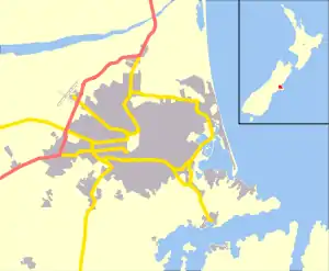 Cashmere | |
| Coordinates: 43.572751°S 172.631100°E | |
| Country | New Zealand |
| Local authority | Christchurch |
| Electoral ward | Cashmere[1] |
| Area | |
| • Land | 471 ha (1,164 acres) |
| Population (2018)[2] | |
| • Total | 6,453 |
| Hospitals(s) | Princess Margaret Hospital |
| Hoon Hay | Somerfield | Beckenham |
| Cracroft |
|
Huntsbury |
| (Port Hills) |
Geography
Cashmere is situated on the north side of the Port Hills, immediately above the southern terminus of Colombo Street and approximately five kilometres south of the city centre. The suburb's location on the Port Hills offers it a commanding view over the rest of the mostly flat city. Cashmere's proximity to the rest of the Port Hills has also made it a favourite for recreation, with the upper reaches of the suburb dominated by Victoria Park with its multiple bike and walking tracks and connections to further tracks running the length of the Port Hills. Above Victoria Park is Sugarloaf, a 496 metres (1,627 ft) peak which is the location of a 119 metres (390 ft) transmission tower used for local radio and TV stations. The Ōpāwaho / Heathcote River marks the northern extent of the suburb, flowing roughly along the base of the Port Hills.
History
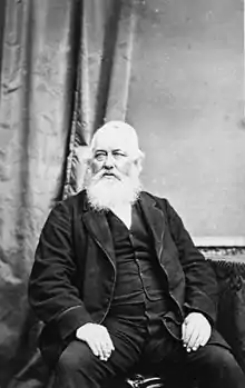
Cashmere takes its name from Sir John Cracroft Wilson's farm in the area, which in turn was named after his birthplace of Kashmir (with Cashmere being the British spelling of that region at the time).[3] Wilson briefly moved to Christchurch in 1854 from India by way of Australia, where he purchased 108 hectares of land to develop into Cashmere farm. Wilson built multiple farm buildings on the property, some of which persist to this day. In 1979, the house Wilson built for his Indian workers became a function centre known as "The Old Stone House". The building has been significantly damaged and restored twice, following a fire in 1971 and earthquakes in 2010 and 2011.[4]
In the late 19th century, the area around Cashmere began to be settled by Europeans. Homes began to be built in Cashmere in the 1890s, although informal church services were being held as early as the 1880s.[5] In response to the growth of this congregation, land from John Cracroft Wilson donated land for a church, which was completed in 1908 and marked the parish's formal split from neighbouring Sydenham.[6] At roughly the same time, the Christchurch tramway system was extended to include the area, with the previous Cashmere line being extended from the southern end of Colombo street to the future site of the Sign of the Takahe.[7] The tram line continued operation until 1954, with Cashmere gaining a reputation as one of the country's more well-to-do and refined suburbs in the process. This reputation continues to the present day, with the 2018 census showing that Cashmere has a significantly higher percentage of incomes over NZ$70,000 than the rest of Christchurch city.[2]
Buildings and infrastructure
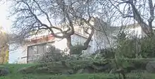
Two of Harry Ell's rest houses, the Sign of the Takahe and the Sign of the Kiwi, are located in Cashmere. Both are Category I heritage buildings.[8][9] Dame Ngaio Marsh's former house in Valley Road is a museum run in her memory. It is registered by Heritage New Zealand as a Category I heritage item.[10]
Schools include Cashmere Primary, Thorrington Primary and Cashmere High School. Princess Margaret Hospital, built in 1959, was once thought to become the main hospital of Christchurch, but it was too far from the central city.[11]
The Cashmere Club is home to many local sports groups including rugby, soccer, bowls, badminton, darts, squash and small bore rifle shooting. The Canterbury Ring Laser facility is located in the Cracroft Caverns, an underground bunker complex built during World War II. Christchurch Adventure Park is a mountain bike park that opened in December 2016.[12]
Notable residents
- Ruth Dyson (born 1957), politician
- Norman Hardie (born 1924), mountaineer[13]
- Ngaio Marsh (1895–1982), world-renowned crime writer who lived in 37 Valley Road from 1907 until her death[14]
- John Cracroft Wilson (1808–1881), Member of Parliament
- Ursula Bethell (1874–1945), poet
References
- "Wards, Councillors and Community Boards map". ccc.govt.nz. Christchurch City Council. Retrieved 14 August 2020.
- The population and area are the sum of the population and area in statistical areas of Cashmere East and Cashmere West
- Kristiansen, Tessa. "Wilson, John Cracroft – Biography". Dictionary of New Zealand Biography. Ministry for Culture and Heritage. Retrieved 10 July 2011.
- Cracroft Community Centre Inc. "History". The Old Stone House. Retrieved 27 July 2018.
- Wilson, John. "Canterbury places – The Port Hills". teara.govt.nz. Ministry for Culture and Heritage. Retrieved 27 December 2020.
- "History of the church – St Augustines Anglican Church – Cashmere". Retrieved 27 December 2020.
- "Tramway Historical Society – Welcome". www.ferrymeadtramway.org.nz. Retrieved 27 December 2020.
- "Sign of the Takahe". Register of Historic Places. Heritage New Zealand. Retrieved 10 July 2011.
- "Sign of the Kiwi". Register of Historic Places. Heritage New Zealand. Retrieved 10 July 2011.
- "Ngaio Marsh House". Register of Historic Places. Heritage New Zealand. Retrieved 10 July 2011.
- "Cashmere (later Princess Margaret) Hospital, shown under construction". Christchurch City Libraries. Retrieved 6 June 2011.
- Redmond, Adele (17 December 2016). "Christchurch Adventure Park opens to Stoke Pass holders on Saturday". The Press. Retrieved 17 December 2016.
- "Man of the mountains". The Press. 29 November 2008. Retrieved 27 August 2016.
- Stafford, Jane. "Marsh, Edith Ngaio 1895–1982". Dictionary of New Zealand Biography. Ministry for Culture and Heritage. Retrieved 10 July 2011.