Barney View, Queensland
Barney View is a rural locality in the Scenic Rim Region, Queensland, Australia.[2] In the 2016 census, Barney View had a population of 64 people.[1]
| Barney View Queensland | |||||||||||||||
|---|---|---|---|---|---|---|---|---|---|---|---|---|---|---|---|
 | |||||||||||||||
 Barney View | |||||||||||||||
| Coordinates | 28.2375°S 152.7644°E | ||||||||||||||
| Population | 64 (2016 census)[1] | ||||||||||||||
| • Density | 1.744/km2 (4.52/sq mi) | ||||||||||||||
| Postcode(s) | 4287 | ||||||||||||||
| Area | 36.7 km2 (14.2 sq mi) | ||||||||||||||
| Time zone | AEST (UTC+10:00) | ||||||||||||||
| LGA(s) | Scenic Rim Region | ||||||||||||||
| State electorate(s) | Scenic Rim | ||||||||||||||
| Federal Division(s) | Wright | ||||||||||||||
| |||||||||||||||
Geography
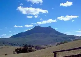
Mount Maroon rises to 966 m above sea level in the west of Barney View. This western section is protected within Mount Barney National Park. The upper Logan River passes through the west of the locality and marks a portion of the western border. In the south the terrain rises to more than 500 m along the northern slopes of Mount Giles. The privately operated Flanagan Reserve Bush Camping allows visitors to camp at a 12 ha site along the river.
History
_Church%252C_Barney_View%252C_2006.JPG.webp)
Barney View Methodist church was opened in 1908; it is now a Uniting Church.[3]
Barney View Lutheran church was dedicated on Wednesday 16 November 1910 with sermons in both German and English.[4] The church closed in 1966.[3] In the 1970s the church building was relocated to Rathdowney to extend the Rathdowney Methodist (later Uniting) Church.[5] The Lutheran Church still owns the land on Barney View Road (now just within the boundaries of Palen Creek, 28.2672°S 152.7884°E) and operates it as a campsite called Abode Park. It is named after Pastor Armin Bode who was a Lutheran minister in the Parish of Teviotville (which included Barney View) from 1915 to 1969.[3][6][7] A memorial at the park commemorates the former church.[3]
Barney View was originally known as Thulimbah, which was frequently confused with another Queensland district of the same name, Thulimbah near Stanthorpe. The problem was resolved in 1916 by changing the name to Barney View (due to its location beside Mount Barney).[8]
Following the closure of the Readville (Widgee Creek) State School in 1911, it was decided in April 1918 to relocate the building to establish a school at Barney View.[9] Barney View State School opened on 4 October 1918. It had a temporary closure from 1938 to circa 1941 due to low student numbers. It closed permanently in March 1961.[10][11] It was located on a bend in the Mount Barney Road (28.2412°S 152.7651°E).[12]
Heritage listings
Heritage-listed sites at Barney View include:
- 101 Mount Barney Road: Barney View Church and Cemetery[13]
Demographics
Barney View has a population of 64 at the 2016 census. The locality contains 32 households, in which 45.9% of the population are males and 54.1% of the population are females with a median age of 54, 16 years above the national average. The average weekly household income is $833, $605 below the national average.[1]
References
- Australian Bureau of Statistics (27 June 2017). "Barney View (SSC)". 2016 Census QuickStats. Retrieved 20 October 2018.

- "Barney View – locality in Scenic Rim Region (entry 45108)". Queensland Place Names. Queensland Government. Retrieved 5 November 2019.
- Boonah Shire Council. "Heart of the Scenic Rim" (PDF). Scenic Rim Regional Council. p. 28.
- "Advertising". The Beaudesert Times. 3 (110). Queensland, Australia. 11 November 1910. p. 3. Retrieved 19 September 2020 – via National Library of Australia.
- Marschke, Tanya (26 February 2014). "Rathdowney worshipers say final prayers at Uniting Church". Beaudesert Times. Retrieved 18 September 2020.
- "Abode Park". Lutheran Youth of Queensland. Retrieved 19 September 2020.
- Bode, Armin, Pastor Armin Bode Papers, ca. 1890s-1994, State Library of Queensland, retrieved 19 September 2020
- Heart of the Scenic Rim, Boonah Tourism
- "Barney View State School". The Beaudesert Times. Queensland, Australia. 5 April 1918. p. 2. Retrieved 30 April 2020 – via Trove.
- Queensland Family History Society (2010), Queensland schools past and present (Version 1.01 ed.), Queensland Family History Society, ISBN 978-1-921171-26-0
- "Opening and closing dates of Queensland Schools". Queensland Government. Retrieved 18 April 2019.
- "Dugandan" (Map). Queensland Government. 1935. Retrieved 30 April 2020.
- "Local Heritage Register" (PDF). Scenic Rim Regional Council. Archived from the original (PDF) on 24 September 2015. Retrieved 9 February 2015.
External links
| Wikimedia Commons has media related to Barney View, Queensland. |