Running Creek, Queensland
Running Creek is a large rural locality in the Scenic Rim Region, Queensland, Australia.[2] It borders New South Wales.[3]
| Running Creek Queensland | |||||||||||||||
|---|---|---|---|---|---|---|---|---|---|---|---|---|---|---|---|
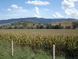 McPherson Range and corn crop, 2016 | |||||||||||||||
 Running Creek | |||||||||||||||
| Coordinates | 28.251°S 152.887°E | ||||||||||||||
| Population | 463 (2011)[1] | ||||||||||||||
| Established | 1997 | ||||||||||||||
| Postcode(s) | 4287 | ||||||||||||||
| LGA(s) | Scenic Rim Region | ||||||||||||||
| State electorate(s) | Scenic Rim | ||||||||||||||
| Federal Division(s) | Wright | ||||||||||||||
| |||||||||||||||
Glenapp is a neighbourhood within Running Creek (28.2733°S 152.906944°E).[4]
Geography
Mount Chinghee (28.3003°S 152.9576°E) and Mount Chinghee National Park (28.3003°S 152.9475°E) are located in the south east of Running Creek.[5][6] The national park has no walking tracks or visitor facilities. It aims to protect remnant rainforest and preserve habitat.[7]
The Sydney–Brisbane rail corridor traverses the length of the north south axis of Running Creek. At the border the railway enters a tunnel and then traverses the Cougal Spiral.
Nearby the Lions Road passes through Richmond Gap (28.3319°S 152.9731°E)[8] on the McPherson Range and links to Cougal in northern New South Wales.
The terrain is generally hilly with elevations rising in the south to well above 600 metres along the McPherson Range. It covers the area roughly equivalent to the catchment formed by Running Creek, with the exception of its most upper parts which lie in Mount Gipps and Southern Lamington. Running Creek, itself a tributary of the Logan River, has a number of tributaries including New Year Creek and Camp Creek. Vegetation has been cleared in many parts for primary production purposes.[7]
History
Timber was an important early industry in the area. There were sawmills at Running Creek and Glenapp. These sawmills no longer exist.[9]
Glenapp Provisional School opened on 19 August 1901. On 1 January 1909 it became Glenapp State School. It closed on 9 December 1960.[10] It was located on the eastern side of Running Creek Road south of the junction with Spring Creek Road (28.2656°S 152.9109°E).[11]
The Beaudesert Shire Tramway operated between Beaudesert to Rathdowney and Lamington from 1903 to 1944. It had a stop in Running Creek called Dulbolla station (28.2142°S 152.8828°E).[12]
The Glenapp railway signal box is located on the eastern side of the Brisbane-to-Sydney railway line at Running Creek (28.2845°S 152.9057°E). The hut was established in 1930 and is only one of a few remaining intact in the country.[13] Having been made redundant due to automation, it was proposed to demolish the Glenapp signal box in 2007. However, the "Glenapp boys" Den and Rob Sibson, who had grown up in the Glenapp community, decided to rescue and restore the signal box as a small museum.[14][15] The Glenapp railway siding was relocated to the Rathdowney Historical Museum.[16]
Telemon Environment Park which later became known as Mount Chinghee National Park was first gazetted in 1994.[7]
In the 2011 census, Running Creek and surrounding localities had a population of 463 people.[1]
Education
There are no schools in Running Creek. The nearest primary school is Rathdowney State School in neighbouring Rathdowney. The nearest secondary school is Beaudesert State High School in Beaudesert .[17]
See also
References
- Australian Bureau of Statistics (31 October 2012). "Innisplain (SSC)". 2011 Census QuickStats. Retrieved 19 March 2016.

- "Running Creek (entry 45185)". Queensland Place Names. Queensland Government. Retrieved 19 March 2016.
- "Queensland Globe". State of Queensland. Retrieved 4 May 2020.
- "Glenapp – neighbourhood in Running Creek in Scenic Rim Region (entry 39778)". Queensland Place Names. Queensland Government. Retrieved 30 April 2020.
- "Mount Chinghee – mountain in the Scenic Rim Region (entry 7143)". Queensland Place Names. Queensland Government. Retrieved 23 August 2020.
- "Mount Chinghee National Park – national park in the Scenic Rim Region (entry 39562)". Queensland Place Names. Queensland Government. Retrieved 23 August 2020.
- "Mount Chinghee National Park Management Statement 2013" (PDF). Department of National Parks, Recreation, Sport and Racing. Archived (PDF) from the original on 30 March 2016. Retrieved 19 March 2016.
- "Richmond Gap – pass in the Scenic Rim Region (entry 28455)". Queensland Place Names. Queensland Government. Retrieved 23 August 2020.
- "History of Rathdowney". Rathdowney Information Centre and Historical Museum. Archived from the original on 3 May 2020. Retrieved 4 May 2020.
- Queensland Family History Society (2010), Queensland schools past and present (Version 1.01 ed.), Queensland Family History Society, ISBN 978-1-921171-26-0
- "Mt Lindsay" (Map). Queensland Government. 1944. Archived from the original on 29 April 2020. Retrieved 30 April 2020.
- "Dulbolla – railway station in the Scenic Rim Region (entry 10779)". Queensland Place Names. Queensland Government. Retrieved 23 August 2020.
- Tanya Marschke (27 August 2014). "Railway history celebrated at Glenapp: Photos". Beaudesert Times. Fairfax Media. Archived from the original on 29 March 2016. Retrieved 19 March 2016.
- Marschke, Tanya (27 August 2014). "Railway history celebrated at Glenapp: Photos". Beaudesert Times. Retrieved 23 August 2020.
- Schaefer, Timothy (31 December 2016). "Devoted to Glenapp Stn". Queensland Country Life. Retrieved 23 August 2020.
- "Dulbolla & Glenapp Railway Sidings". Rathdowney Historical Museum. Retrieved 23 August 2020.
- "Queensland Globe". State of Queensland. Retrieved 3 May 2020.
Further reading
- Teese, Nerelie (2001), Hurricane lamps & handmilking : a history of dairy farming along the Logan & Albert River Valleys, Nerelie Teese, ISBN 978-0-9579326-0-9
External links
![]() Media related to Running Creek, Queensland at Wikimedia Commons
Media related to Running Creek, Queensland at Wikimedia Commons