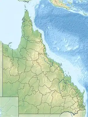
Mount Lindesay (Queensland)
Mount Lindesay is a rural locality in the Scenic Rim Region, Queensland, Australia.[2] It borders New South Wales.[3] In the 2016 census, Mount Lindesay had a population of 3 people.[1]
| Mount Lindesay Queensland | |||||||||||||||
|---|---|---|---|---|---|---|---|---|---|---|---|---|---|---|---|
 Mount Lindesay | |||||||||||||||
| Coordinates | 28.3305°S 152.7333°E | ||||||||||||||
| Population | 3 (2016 census)[1] | ||||||||||||||
| • Density | 0.175/km2 (0.45/sq mi) | ||||||||||||||
| Postcode(s) | 4287 | ||||||||||||||
| Area | 17.1 km2 (6.6 sq mi) | ||||||||||||||
| Time zone | AEST (UTC+10:00) | ||||||||||||||
| LGA(s) | Scenic Rim Region | ||||||||||||||
| State electorate(s) | Scenic Rim | ||||||||||||||
| Federal Division(s) | Wright | ||||||||||||||
| |||||||||||||||
| Mount Lindesay | |
|---|---|
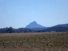
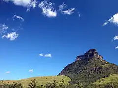
 The distinctly shaped peak of Mount Lindesay | |
| Highest point | |
| Elevation | 1,177 m (3,862 ft) |
| Geography | |
 Mount Lindesay Queensland, Australia | |
| Parent range | McPherson Range |
| Climbing | |
| First ascent | 1872 |
The mountain of the same name (height 1,175 metres (3,855 ft)) is located on the south-west boundary of the locality (28.3447°S 152.7228°E) on the border between Queensland and New South Wales.[4]
Geography
The mountain lies on the Queensland-New South Wales border, approximately 140 km south west of Brisbane, Australia. It is one of a number of peaks in the McPherson Range, and is remarkable for its tiered summit, the eroded remnant of lava flows from the nearby Focal Peak shield volcano.[5] Mount Lindesay is situated within the Mount Barney National Park in Queensland and the Border Ranges National Park in New South Wales. Apart from the northern slopes, the rest of the peak is covered in dense rainforest, and the summit is frequently in cloud and mist. The Mount Lindesay Highway passes to the western side of Mount Lindesay. A wildfire from the south in November 2019 burned across the mountain above the cliffs for the first time in living memory, reaching the summit from the western side. Most of the forest on top was burned, apart from several narrow bands on the lower veranda and a small area of rainforest, east of the summit.
History
On 6 July 1828, the botanist and explorer Allan Cunningham originally named this mountain Mount Hooker after botanist William Hooker and called another mountain (now Mount Barney) by the name Mount Lindesay after Colonel Patrick Lindesay, the Commandant of Troops in New South Wales 1827–1836. Sometime in the late 1830s or early 1840s, either the New South Wales Surveyor-General Thomas Mitchell, or Moreton District surveyor Robert Dixon, are believed to have changed the names to be Mount Lindesay and Mount Barney (after Lieutenant-Colonel George Barney) respectively.[4]
The first known European ascent of Mount Lindesay was most likely by Collector of Customs, William Thornton, and the Kinchela brothers, John and James, sometime between 1846 and 1848.[6] All were stationed in Queensland at the time and knew each other well with the Kinchela brothers based at Telemon station on the Upper Logan within sight of the mountain.[7]
The first recorded (and second) ascent of Mount Lindesay was made in May 1872, by Thomas de Montmorency Murray-Prior (1848-1902) and Phillip Walter Pears (1846-1924). At the time of the 1872 ascent, an Aboriginal elder at nearby Unumgar station claimed to Pears that his father had once climbed the peak.[8]
The second recorded (and third) ascent of Mount Lindesay was made in July 1890, by the Norwegian naturalist and explorer Carsten Egeberg Borchgrevink (1864-1934), then working in the district as a surveyor's labourer, and Edwin Villiers-Brown, of Beaudesert. There were a further eight recorded ascents by the late 1920s, when pioneering climbers such as Bert Salmon (1899-1982) started visiting the peak regularly. The first women to climb Mount Lindesay were Brisbane climbers Jean Easton and Nora Dimes, who made the ascent with Bert Salmon in March 1931.[9]
In December 1928 Mount Lindesay was the site of the first known recreational climbing fatality in Australia, when Lyle Vidler fell to his death whilst attempting a solo ascent of Vidler's Chimney. He is buried in a grave in the rainforest, not far from where he fell.[10] On 19 June 2011, Ross Miller, one of a party of six, fell to his death while climbing in a designated area.[11]
In August 1978 The Northern Star newspaper reported 3 local men (Stephen Marsh, Peter Taylor and Lewis Reid) climbed the mountain and signed a book in a metal container on the peak containing the names of members of another local expedition a few years earlier (John Martin, Barry Martin, Philip Martin, Raymond Martin, Neil Mahoney, George Ellen, John Gorman and John Bushell).
Mount Lindesay has been part of a successful native title claim made by the Trevor Close on behalf of the Githabul people,[12][13] for whom the peak holds a special significance.
Climbing
Despite appearances, Mount Lindesay offers few opportunities for rock-climbers, due to the unsound nature of the rock (decaying rhyolite). There is one steep and exposed scrambling route to the summit, rated at approximately grade 6–7, which starts at the south east corner of the upper cliffs. However, this is not a bushwalking route as such, and anyone making an ascent should have basic rock-climbing and abseiling skills, or be under the guidance of experienced rock-climbers.[14] The wildfire in November 2019 significantly impacted the 'tourist route', particularly on the lower cliff, with much of the vegetation destroyed, leaving unstable and potentially dangerous sections. Until the vegetation regenerates and the stability of the route improves, the risk of falling rock will remain high. The difficulties and seriousness have increased substantially as a result of the fire and it is not recommended for inexperienced climbers. In August 1978 The Northern Star newspaper reported 3 local men (Stephen Marsh, Peter Taylor and Lewis Reid) climbed the mountain and signed a book in a metal container on the peak containing the names of members of another local expedition a few years earlier (John Martin, Barry Martin, Philip Martin, Raymond Martin, Neil Mahoney, George Ellen, John Gorman and John Bushell). A plaque can also be found on the North East side of the mountain marking the grave of a fallen climber named Vidler.
Schools
There are no schools in Mount Lindesay. The nearest primary school is in Rathdowney, while the nearest secondary school is in Beaudesert.[15]
Demographics
Mount Lindesay has a population of 3 at the 2016 census.
See also
References
- Australian Bureau of Statistics (27 June 2017). "Mount Lindesay (SSC)". 2016 Census QuickStats. Retrieved 20 October 2018.

- "Mount Lindesay – locality in Scenic Rim Region (entry 45174)". Queensland Place Names. Queensland Government. Retrieved 5 November 2019.
- "Queensland Globe". State of Queensland. Retrieved 4 May 2020.
- "Mount Lindesay – mountain in the Scenic Rim Region (entry 19447)". Queensland Place Names. Queensland Government. Retrieved 12 November 2019.
- R.W. Johnson, J. Knutson, S.R. Taylor, 1989,Intraplate Volcanism in Eastern Australia and New Zealand
- Mary Murray-Prior, 'An ascent of Mt. Lindesay', Queenslander, 1 November 1902, p.974
- Thomson, Robert (May 2001), "The first ascent of Mt Lindesay: a climbing 'whodunit'", Queensland Review (St Lucia, Qld), 8 (1): 1–20, ISSN 1321-8166
- P.W. Pears, 'Mt. Lindesay', Brisbane Courier, 22 November 1923, p.6
- Thomson, Robert (May 2001), "The first ascent of Mt Lindesay: a climbing 'whodunit'", Queensland Review (St Lucia, Qld), 8 (1): 1–20, ISSN 1321-8166
- "A TRAGIC STORY". The Brisbane Courier. National Library of Australia. 4 January 1929. p. 15. Retrieved 20 February 2014.
- "Tragedy on Mt Lindesay". Beaudesert Times. 23 June 2011. Archived from the original on 22 February 2014. Retrieved 26 March 2012.
- "Githabul People's native title determination" (PDF). Native Title Tribunal. 29 November 2007. Retrieved 12 September 2015.
- "More native title claims planned for southern Qld". ABC News Online. Australian Broadcasting Corporation. 12 September 2007. Retrieved 20 March 2011.
- R.Rankin, 1992, Secrets of the Scenic Rim
- "Queensland Globe". State of Queensland. Retrieved 12 November 2019.
External links
![]() Media related to Mount Lindesay, Queensland at Wikimedia Commons
Media related to Mount Lindesay, Queensland at Wikimedia Commons
