Tabragalba, Queensland
Tabragalba is a rural locality in the Scenic Rim Regionf South East Queensland, Australia.[2] In the 2016 census Tabragalba had a population of 49 people.[1]
| Tabragalba Queensland | |||||||||||||||
|---|---|---|---|---|---|---|---|---|---|---|---|---|---|---|---|
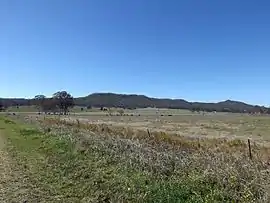 Paddocks along Beaudesert Nerang Road, 2014 | |||||||||||||||
 Tabragalba | |||||||||||||||
| Coordinates | 27.9919°S 153.0663°E | ||||||||||||||
| Population | 49 (2016 census)[1] | ||||||||||||||
| • Density | 1.849/km2 (4.79/sq mi) | ||||||||||||||
| Postcode(s) | 4285 | ||||||||||||||
| Area | 26.5 km2 (10.2 sq mi) | ||||||||||||||
| Time zone | AEST (UTC+10:00) | ||||||||||||||
| LGA(s) | Scenic Rim Region | ||||||||||||||
| State electorate(s) | Scenic Rim | ||||||||||||||
| Federal Division(s) | Wright | ||||||||||||||
| |||||||||||||||
Geography
The eastern border of Tabragalba follows a ridge line and includes Mount Tabragalba. Part of the western boundary is marked by the Albert River. The Beaudesert Nerang Road traverses the northern end. Agriculture is the predominant land use.
History
The locality takes its name from a local pastoral station established in 1843. The name is from the Bundjalung language dhaberi gaba meaning the place of club or nulla nulla.[3][2]
The name was also used for an early local government area called Tabragalba Division (established 1879) which became the Shire of Tabragalba (1903), then renamed a few months later as Shire of Beaudesert. In 2008, the shire was merged into the new Scenic Rim Region.
Tabragalba Provisional School opened on 24 April 1907. On 1 January 1909 it became Tabragalba State School. It closed on 11 July 1945.[4]
In the 2016 census Tabragalba had a population of 49 people.[1]
Heritage listings
Tabragalba has a number of heritage-listed sites, including:
Wyambyn
The heritage-listed Wyambyn homestead was designed by Robin Dods and built in 1909 at Tabragalba. The design features the Arts and Crafts architectural style.[6] Cattle were originally raised on the property until the 1920s when sheep became more profitable.[7] The homestead was used as a setting in the movie Unfinished Sky in 2007.[6]
References
- Australian Bureau of Statistics (27 June 2017). "Tabragalba (SSC)". 2016 Census QuickStats. Retrieved 20 October 2018.

- "Tabragalba – locality in Scenic Rim Region (entry 45190)". Queensland Place Names. Queensland Government. Retrieved 29 December 2020.
- "Tabragalba". Queensland Places. Centre for the Government of Queensland, University of Queensland. Retrieved 1 September 2014.
- Queensland Family History Society (2010), Queensland schools past and present (Version 1.01 ed.), Queensland Family History Society, ISBN 978-1-921171-26-0
- "Wyambyn (entry 602821)". Queensland Heritage Register. Queensland Heritage Council. Retrieved 15 November 2014.
- "Wyambyn (entry 602821)". Queensland Heritage Register. Queensland Heritage Council. Retrieved 1 September 2014.
- "Heritage listing for historic pastoral homestead". Media Release. Queensland Heritage Council. Retrieved 1 September 2014.
External links
![]() Media related to Tabragalba, Queensland at Wikimedia Commons
Media related to Tabragalba, Queensland at Wikimedia Commons