Harrisville, Queensland
Harrisville is a rural town and locality in the Scenic Rim Region, Queensland, Australia.[2][3] In the 2016 census, Harrisville had a population of 613 people.[1]
| Harrisville Queensland | |||||||||||||||
|---|---|---|---|---|---|---|---|---|---|---|---|---|---|---|---|
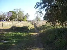 Former Dugandan railway line, 2009 | |||||||||||||||
 Harrisville | |||||||||||||||
| Coordinates | 27.81°S 152.6672°E | ||||||||||||||
| Population | 613 (2016 census)[1] | ||||||||||||||
| • Density | 19.28/km2 (49.93/sq mi) | ||||||||||||||
| Postcode(s) | 4307 | ||||||||||||||
| Area | 31.8 km2 (12.3 sq mi) | ||||||||||||||
| Time zone | AEST (UTC+10:00) | ||||||||||||||
| LGA(s) | Scenic Rim Region | ||||||||||||||
| State electorate(s) | Scenic Rim | ||||||||||||||
| Federal Division(s) | Wright | ||||||||||||||
| |||||||||||||||
Geography
Warrill Creek, a tributary of the Bremer River, passes through the western parts of the town.
History
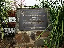
In 1839, a survey baseline of 3 miles (4.8 km) was marked out on the floodplain, then known as Normanby Plains, which now forms part of Harrisville, together with Wilsons Plains and Radford to the south. It was supervised by the surveyor Robert Dixon as the basis of a trigonometrical survey starting with Flinders Peak to the east and Mount Walker (then Mount Forbes) to the west,[4] which began the accurate interior mapping of Queensland. A monument to this work "In the Steps of Our Forefathers" is situated just west of the Harrisville township on the Warrill View Peak Crossing Road, along where the baseline passed (27.8142°S 152.6510°E).
The area formed part of the old Mount Flinders sheep station established by William Wilson (and his brother Robert) around 1844,[5] soon after the Moreton Bay penal colony closed. Some of the land from this station became available to selectors in December 1860 with provision of the Ipswich Agricultural Reserve.[6] In 1863 Robert Dunn selected a portion from this Reserve,[7] from which the Harris brothers purchased their land in 1870.[8]
The town is believed to be named after Harris brothers: John Harris (1819–1895) and George Harris (1831–1891) . They established a store and cotton ginnery in the area.[2] Cotton was a valuable crop at that time as the American Civil War had created a worldwide shortage.[9]
Ipswich Reserve State School opened in 1867. In 1887 it was renamed Harrisville State School. In 1891 it was renamed Hillgrove State School, enabling a new school to open on 19 January 1891 under the name Harrisville State School. The new school reduced attendance at the Hillgrove State School and it was demoted to become Hillgrove Provisional School, but returned to state school status in 1894. Hillgrove State School closed in 1932, but, as at 2019, the "new" Harrisville State School continues to operate.[10]
Harrisville Post Office opened on 1 August 1873 (a receiving office had been open from 1871).[11]
The Fassifern railway line (Queensland's first branch railway line) opened from Ipswich to Harrisville on 10 July 1882 with the town being served by Harrisville railway station in Queen Street (27.8110°S 152.6666°E), while Churchbank railway station was located in Webers Road (27.7891°S 152.6916°E) in the very north of the present day locality of Harrisville on the boundary with Mutdapilly.[12][13] On 12 September 1887 the line was extended to Dugundan. The line closed in 1964.[14]
St John's Anglican Church was dedicated on Sunday 14 April 1878 by Bishop of Brisbane Matthew Hale.[15] On 18 January 1985 the church was destroyed in a storm. The foundation stone for the new St John the Evangelist's Anglican Church was laid on 16 February 1986 by Archbishop John Grindrod. It was consecrated on 20 April 1986 by Assistant Bishop Adrian Owen Charles.[16][17]
In November 1909, 17 farms of 131 to 336 acres in the Bald Ridges estate Normanby (near Harrisville) were advertised to be auctioned by Isles Love.[18] A map advertising the auction states the Estate was 6 miles from the railway station being within three hours form Brisbane.[19]
A private hospital operated from 1911 until 1973.[20]
The centenary of Harrisville was celebrated in 1963 with a street parade and centenary ball organised by the Harrisville Centenary Celebrations Committee.[21] In 2013 Harrisville commemorated 150 years with a street procession and unveiling of a plaque by Penelope Wensley, the Governor of Queensland.[22]
Heritage listings
Harrisville has the following heritage sites:
- 13 Church Street: Courthouse and Police Lock-up[23]
- 5 Hall Street: School of Arts[23]
- 16 Hall Street: Masonic Hall[23]
- 34 Queen Street: Commercial Hotel[23]
- 35 Queen Street: Former Royal Bank[23]
- 43–47 Queen Street: Memorial Park[23]
- 54–58 Queen Street: Sacred Heart Catholic Church[23]
- 1–5 Wholey Drive: Royal Hotel[23]
Community groups
The Harrisville Historical Society maintains a museum in Queen Street which includes a rain-gun used during the 1902 drought.
The Harrisville branch of the Queensland Country Women's Association meets at the QCWA Rest Rooms at 43 Queen Street.[24]
Amenities
The Scenic Rim Regional Council operates a mobile library service which visits the Memorial Park.[25]
St John's Anglican Church is at 1 Church Street (27.8086°S 152.6632°E).[26] Two Sunday services are held each month.[27]
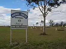
Harrisville Cemetery is at the intersection of Harrisville-Peak Crossing Road and Webers Road (27.8034°S 152.6909°E) and is operated by local trustees.[28]
Education
Harrisville State School is a government primary (Prep-6) school for boys and girls at 17 Hall Street (27.8126°S 152.6673°E).[29][30] In 2017, the school had an enrolment of 91 students with 10 teachers (6 full-time equivalent) and 15 non-teaching staff (6 full-time equivalent).[31]
Demographics
Harrisville has a population of 613 at the 2016 census. The locality contains 241 households, in which 48.8% of the population are males and 51.2% of the population are females with a median age of 39, 1 year above the national average. The average weekly household income is $1,298, $140 below the national average.
4.5% of Harrisville's population is either of Aborigional or Torres Strait Islander descent. 64.8% of the population aged 15 or over is either registered or de facto married, while 35.2% of the population is not married. 30.3% of the population is currently attending some form of a compulsory education. The most common nominated ancestries were Australian (34.3%), English (30.5%) and German (10.3%), while the most common country of birth was Australia (85.0%), and the most commonly spoken language at home was English (94.1%). The most common nominated religions were No religion (24.2%), Anglican (21.6%) and Catholic (19.0%). The most common occupation was a technician/trades worker (16.6%) and the majority/plurality of residents worked 40 or more hours per week (44.1%).[1]
References
- Australian Bureau of Statistics (27 June 2017). "Harrisville (SSC)". 2016 Census QuickStats. Retrieved 20 October 2018.

- "Harrisville – town in Scenic Rim Region (entry 15450)". Queensland Place Names. Queensland Government. Retrieved 17 November 2019.
- "Harrisville – locality in Scenic Rim Region (entry 49609)". Queensland Place Names. Queensland Government. Retrieved 17 November 2019.
- Kitson, Bill; McKay, Judith (2006). "Control Surveys". Surveying Queensland 1839–1945 : A Pictorial History. Dept. of Natural Resources and Water, and Queensland Museum. pp. 40–41. ISBN 9780975111642.
- "Index to Squatters and Graziers". The State Records Authority of New South Wales. Retrieved 8 June 2015.
- "Agricultural Reserve". The Moreton Bay Courier. 1 January 1861. p. 3. Retrieved 8 June 2015 – via National Library of Australia.
- Queensland. Parliament. Legislative Assembly (1860), Votes and proceedings of the Legislative Assembly ... with the various documents connected therewith, T.P. Pugh's Printing Office, pp. 634–635, archived from the original on 16 December 2017, retrieved 16 December 2017
- "Early Days of Harrisville". The Queensland Times. 27 June 1945. p. 3. Retrieved 8 June 2015.
- "Scenic Rim Stories and Communities". Visit Scenic Rim. Scenic Rim Regional Council. Archived from the original on 5 October 2013. Retrieved 15 September 2013.
- Queensland Family History Society (2010), Queensland schools past and present (Version 1.01 ed.), Queensland Family History Society, ISBN 978-1-921171-26-0
- Premier Postal History. "Post Office List". Premier Postal Auctions. Retrieved 10 May 2014.
- "Opening Fassifern Branch Railway". The Brisbane Courier. 6 July 1882. p. 1. Retrieved 8 June 2015 – via National Library of Australia.
- "Flinders" (Map). Queensland Government. 1927. Archived from the original on 29 May 2020. Retrieved 29 May 2020.
- Kerr, John (1990). Triumph of narrow gauge : a history of Queensland Railways. Boolarong Publications. pp. 57–58, 224. ISBN 978-0-86439-102-5.
- "OPENING OF THE NEW ANGLICAN CHURCH AT HARRISVILLE". Queensland Times, Ipswich Herald And General Advertiser. XVII (2386). Queensland, Australia. 16 April 1878. p. 3. Retrieved 18 September 2020 – via National Library of Australia.
- "Year Book" (PDF). Anglican Archdiocese of Brisbane. 2019. p. 133. Archived (PDF) from the original on 15 September 2020. Retrieved 15 September 2020.
- "St John's Anglican Church". Churches Australia. Retrieved 18 September 2020.
- "Advertising". The Telegraph (11, 541). Queensland, Australia. 12 November 1909. p. 10. Retrieved 5 June 2019 – via National Library of Australia.
- "Bald Ridges estate". rosettadel.slq.qld.gov.au. Retrieved 4 June 2019.
- "Harrisville and Normanby Shire". Queensland Places. Centre for the Government of Queensland, University of Queensland. Archived from the original on 3 September 2014. Retrieved 2 September 2014.
- "OM78-37 Harrisville Centenary Celebrations Committee Records". John Oxley Library, State Library of Queensland. Retrieved 8 June 2015.
- "Queensland Governor visits Harrisville to mark milestone". Ipswich Queensland Times. Archived from the original on 16 December 2017. Retrieved 8 June 2015.
- "Local Heritage Register" (PDF). Scenic Rim Regional Council. Archived from the original (PDF) on 24 September 2015. Retrieved 9 February 2015.
- "Branch Locations". Queensland Country Women's Association. Archived from the original on 26 December 2018. Retrieved 26 December 2018.
- "Mobile Library" (PDF). Scenic Rim Regional Council. Archived from the original (PDF) on 30 January 2018. Retrieved 31 January 2018.
- "St John's Anglican Church". Churches Australia. Retrieved 18 September 2020.
- "St. John's Anglican Church, Harrisville". Anglican Parish of Boonah-Harrisville. Retrieved 18 September 2020.
- "Private Cemeteries: Scenic Rim Region and Surrounds". Scenic Rim Regional Council. Archived from the original on 17 May 2020. Retrieved 29 May 2020.
- "State and non-state school details". Queensland Government. 9 July 2018. Archived from the original on 21 November 2018. Retrieved 21 November 2018.
- "Harrisville State School". Archived from the original on 26 March 2012. Retrieved 21 November 2018.
- "ACARA School Profile 2017". Archived from the original on 22 November 2018. Retrieved 22 November 2018.
Further reading
- Pugsley, Harry (1963), Souvenir brochure of Harrisville centenary celebrations, 1963, Centenary Celebrations Management Committee, retrieved 30 November 2019
- Harrisville Centenary Celebrations Committee (1991), Harrisville State School Centenary, 1891-1991, Harrisville Centenary Committee — also covers Hillgrove, Milora and Radford Schools
- Harrisville and District Historical Society (issuing body.) (2013), Harrisville sesquicentenary : 1863-2013, Harrisville Historical Society
- Collyer, Angela (1992). The process of settlement: Land occupation and usage in Boonah 1842-1870s (PDF) (M.A.). School of History, Philosophy, Religion, and Classics; The University of Queensland.
External links
| Wikimedia Commons has media related to Harrisville, Queensland. |