Beckenham, New Zealand
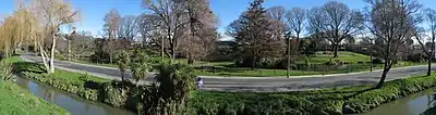
Beckenham is an inner suburb of Christchurch, New Zealand, located three kilometres south of the city centre. The Ōpāwaho / Heathcote River winds through this predominantly residential suburb, a section of which is often referred to locally as the "Beckenham Loop". Beckenham is bounded by Sydenham to the north, Somerfield to the west, Cashmere and Huntsbury to the south and St Martins to the east.
Beckenham | |
|---|---|
Suburb | |
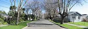 Fisher Avenue, Beckenham | |
 Beckenham 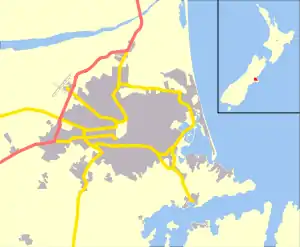 Beckenham | |
| Coordinates: 43°33′48″S 172°38′37″E | |
| Country | New Zealand |
| Local authority | Christchurch |
| Electoral ward | Cashmere[1] |
| Area | |
| • Land | 88 ha (217 acres) |
| Population (2018)[2] | |
| • Total | 2,403 |
| Sydenham | St Martins | |
| Somerfield |
|
|
| Cashmere | Huntsbury |
History
European settlement of Beckenham dates back to the first arrival of British settlers in Christchurch, and was part of the initial allocation of land to the new settlers. The Beckenham area, which was known as Middle Heathcote at the time, was divided into two plots of farmland - the first of which was purchased by brothers Stephen and James Fisher, with the other going to James' father-in-law.[3] Stephen Fisher named the area Beckenham after the English town of the same name, although the name Fisherton was also used in honour of the brothers.[4] The brothers and their family farmed the area until their deaths, at which point demand for residential land in Christchurch was growing. The farms were subdivided in 1906, forming the new suburbs of Beckenham and Fisherton in the process. The suburb grew in size as the Christchurch tramway system expanded into the area, down Colombo Street to Devon Street (1880), then Tennyson Street and finally to the Port Hills (1898), providing easy access from the suburb to the central city. During this process, the name Fisherton gradually fell into disuse, with the name Beckenham being applied to the whole area[4] Electricity was provided to Beckenham in 1912 and a waste water scheme was provided in the 1920s.[4]
Amenities
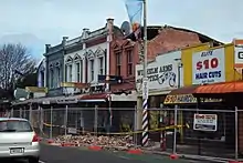
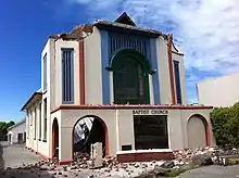
The Beckenham shopping area has had a number of buildings demolished as a result of the 2010-11 earthquakes, but overall the area continues to thrive, with a butcher, café, pharmacy and post shop, among other businesses. Several restaurants[5][6]and the Hettie's Rock Shop are popular with local residents. The Christchurch South Police Station is located on Colombo Street.
Beckenham is home to the Beckenham Methodist Church,[7] Beckenham Baptist Church[8] and St Peters Beckenham Catholic Church.[9]
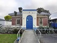
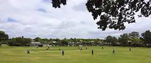
Beckenham Park has duck ponds, is the home to the Southern Districts Cricket Club[10] and the Beckenham Tennis Club.[11] The Christchurch South Library is located on Colombo Street by the Heathcote river. It was designed by architects Warren and Mahoney, and officially opened on 23 August 2003. It received a supreme award for architecture at the 2004 NZIA awards.[12] The Opawa-Saint Martins Toy Library is located in the old Beckenham Library on Sandwich Road.[13]
Houses
There are many original houses built in the 1900s through to 1950. They consist of single and the occasional two-story villa, some brick single story dwellings, wooden bungalows, and a few Art Deco houses. There are a number of larger houses on Fisher Avenue. Many have well established front gardens, The streets are relatively wide, and there are many mature trees on the streets.[14] Some subdivision has occurred with new houses located behind the original houses with separate driveways and associated fencing. The trees on Fisher Avenue and Norwood Street contribute to Beckenham by creating a pleasant street appearance.[14]
Flooding issues
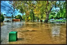
Beckenham's location on the banks of the Ōpāwaho / Heathcote River means that it is prone to flooding during heavy rain events, like many suburbs in the lower reaches of the Ōpāwaho. The Christchurch City Council continues to implement flood mitigation strategies to lessen the impact of this.[15][16][17]
Demographics
In 2006, Beckenham had a population of 2451 residents, 2442 residents in 2013 and 2403 residents in 2018. The median age of the residents in 2018 was 41.2 years old. In terms of ethnicity, 93.4% of residents identified as European, 6.2% identified as Maori and 7.6% identified as of Maori descent. The majority of residents were born in New Zealand (75.9%). The majority of residents identified with no religion (61.7%) while a sizeable minority (29.8) identified as Christian. The majority of residents (52.6%) were in full time employment. The median income was $39,000 with 25.3% earning over $70,000.[18]
In 2018, there were 897 occupied private dwellings and a further 48 unoccupied private dwellings.[18]
Beckenham Primary School
Beckenham Primary School is a state, co-educational, primary school catering for school Years 1 to 8. Beckenham Primary School opened in 1915 with 149 pupils and a staff of four, following lobbying to the Canterbury Education Board by the Beckenham Burgesses’ Association, who argued that it was too dangerous for Beckenham children to cross Colombo St tramlines to attend Somerfield School. The school roll and its buildings grew rapidly so that by 1928 the school roll reached 562.The roll in recent years (2020) has ranged from around 430 at the beginning of the school year and rising to around 510 by the end of the year. The Canterbury Earthquake of 22 Feb 2011 destroyed the school pool. A fire in January 2013 destroyed the library and multipurpose rooms. Approximately 13% of the school’s population is Māori and there is a strong support for school te reo Māori and Tikanga Māori programmes within the community. Children of other ethnic backgrounds include Cook Island Māori, Samoan, Tongan, Indian, Russian, Hungarian, Dutch, German, African, Korean, Japanese and Chinese. The school has an attached satellite class from Ferndale School for moderately intellectually disabled children. The first school committee adopted the red, yellow and black colours of the Belgian flag as the school colours as a tribute to the bravery shown by that country in the 1914-1918 World War.[19] Beckenham is currently a decile 8 school.[20] Beckenham Primary School is also known as Beckenham Te Kura o Pūroto.[21]
| Wikimedia Commons has media related to Beckenham, New Zealand. |
External links
Notes
- "Wards, Councillors and Community Boards map". ccc.govt.nz. Christchurch City Council. Retrieved 14 August 2020.
- "2018 Census place summaries: Beckenham". www.stats.govt.nz. Statistics New Zealand. Retrieved 8 January 2021.
- "Beckenham Land Story" (PDF). Beckenham Methodist Church. Retrieved 7 January 2021.
- "Beckenham". my.christchurchcitylibraries.com. Retrieved 22 September 2020.
- "Pizza Pasta Italian Christchurch | The Birdwood, Pizzeria & Eatery. | Beckenham". The Birdwood. Retrieved 18 September 2020.
- "Formaggio's Italian Restaurant & Pizzeria I Christchurch". Formaggios. Retrieved 18 September 2020.
- "Beckenham Methodist Church". www.bmc.nz. Retrieved 20 September 2020.
- "Beckenham Baptist Church". Beckenham Baptist Church. Retrieved 18 September 2020.
- "Beckenham - St Peter's". Catholic Diocese of Christchurch. Retrieved 20 September 2020.
- "Southern Districts Cricket Club". Retrieved 18 September 2020.
- "Beckenham Tennis Club". Tennis Canterbury. Retrieved 18 September 2020.
- "About South Library". my.christchurchcitylibraries.com. Retrieved 18 September 2020.
- "About Us". Opawa St Martins Plunket Toy Library. Retrieved 18 September 2020.
- "Beckenham Loop Design Guide 2019" (PDF). Christchurch City Council. 2019.
- "Homes near Heathcote River surrounded by water". Stuff. 22 July 2017. Retrieved 8 November 2020.
- "Widespread flooding across Christchurch and Kaiapoi after Cyclone Cook passes through". Stuff. 14 April 2017. Retrieved 8 November 2020.
- staff, 3 News online. "Flooding closes roads, schools". Newshub. Retrieved 8 November 2020.
- "2018 Census place summaries | Stats NZ". www.stats.govt.nz. Retrieved 16 October 2020.
- "History – Beckenham Te Kura o Pūroto". Retrieved 18 September 2020.
- "Dave Wilcox NZ Schools Database". Retrieved 18 September 2020.
- "Beckenham Te Kura o Pūroto". Retrieved 20 September 2020.