Linwood, New Zealand
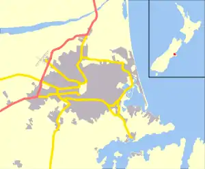
Linwood is an inner suburb of the city of Christchurch, New Zealand. It lies to the east of the city centre, mostly between Ferry Road and Linwood Avenue, two of the major arterial roads to the eastern suburbs of Christchurch.
Linwood | |
|---|---|
 Linwood | |
| Coordinates: 43°31′53″S 172°40′21″E | |
| Area | |
| • Total | 2.8345 km2 (1.0944 sq mi) |
| Population (2013) | |
| • Total | 4,290 |
| • Density | 1,500/km2 (3,900/sq mi) |
History
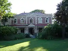
Linwood was given its name by Joseph Brittan, who purchased rural section 300 in Avonside. The adjoining rural section 301 was to be part of the farm, but the right was sold but probably farmed with rural section 300 and was eventually bought back by his son in 1874. To this was added a small part of section 30 to give access in 1855 and 21-year lease for the adjoining sections in 1862 giving a total area of about 380 acres (about 150ha).[1][2] He called the farm Linwood, as he was from Linwood, Hampshire.[3] Brittan built Linwood House at 30 Linwood Avenue in 1857, which stood there until demolition following the February 2011 Christchurch earthquake.[2][4]
Christchurch lacked an accessible port before the construction of the Lyttelton Rail Tunnel in 1867. This posed a significant problem for the fledgling city. A barge service along what is now Linwood Avenue was mooted prior to this tunnel but was never completed.
The Linwood Islamic Centre was the site of a mass shooting during the Christchurch mosque shootings on 15 March 2019.[5]
Economy
Retail
Linwood's commercial area is concentrated around the intersection of Linwood Avenue, Aldwins Road and Buckleys Road.
Eastgate Mall covers an area of 30,500 m².[6] It has 1100 carparks and 40 shops, including The Warehouse, Countdown, Warehouse Stationery, Number One Shoes and Lincraft.[7]
Parks
The largest parks in Linwood are Bromley Park[8] and the adjacent Linwood Cemetery,[9] followed by Beverley Park[10] and the North Linwood Community Park. As there are no defined suburb boundaries in Christchurch, post code boundaries are sometimes used for suburb boundaries (e.g. by Google Maps). According to Google Maps, most of Woodham Park[11] is located in Linwood whilst only part of Linwood Park[12] belongs to the eponymous suburb. Most commonly, Aldwins Road and Linwood Avenue are considered the boundary roads of Woolston and if so, Linwood Park is located in Woolston.
Education
Local schools include:
- Linwood College
- Linwood Avenue Primary School
- Linwood North School
- Te Pā o Rākaihautū (Kura Kaupapa Māori founded in 2015)[13]
Notable people
References
- Archives NZ land records
- "Linwood House". Register of Historic Places. Heritage New Zealand. Retrieved 13 August 2011.
- Greenaway, Richard L. N. (June 2007). "Avonside Anglican Parish Cemetery Tour" (PDF). Christchurch City Libraries. p. 9. Retrieved 13 August 2011.
- Cronshaw, Tim (5 March 2011). "Heritage heartbreak looms". The Press. Retrieved 13 August 2011.
- Bayer, Kurt; Leasl, Anna (24 August 2020). "Christchurch mosque terror attack sentencing: Gunman Brenton Tarrant planned to attack three mosques". New Zealand Herald. Retrieved 24 August 2020.
- Gibson, Anne (23 December 2001). "Growth plans for Eastgate Mall". Wilson & Horton. New Zealand Herald.
- "Our shops - Eastgate Mall". eastgate.co.nz. Eastgate Mall.
- "Bromley Park". findchch.com. Retrieved 7 September 2019.
- "Linwood Cemetery". findchch.com. Retrieved 7 September 2019.
- "Beverley Park & Playground". findchch.com. Retrieved 7 September 2019.
- "Woodham Park". findchch.com. Retrieved 7 September 2019.
- "Linwood Park". findchch.com. Retrieved 7 September 2019.
- "Te Pā o Rākaihautū". rakaihautu.com. Retrieved 7 September 2019.