Spreydon
Spreydon is a suburb of Christchurch, New Zealand, 4 kilometres (2.5 mi) south-south-west of Cathedral Square. The most central street through Spreydon is Barrington Street. Spreydon is flanked by the suburbs Hoon Hay, Sydenham, and Lower Cashmere. State Highway 76 marks the northern boundary of the suburb, including the eastern end of the Christchurch Southern Motorway.
Spreydon | |
|---|---|
Suburb | |
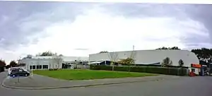 Pioneer Sport and Recreation Centre, a major sports facility in Spreydon | |
 Spreydon 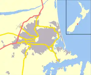 Spreydon | |
| Coordinates: 43°34′S 172°37′E | |
| Country | New Zealand |
| Local authority | Christchurch |
| Electoral ward | Spreydon[1] |
| Area | |
| • Land | 224 ha (554 acres) |
| Population (2018)[2] | |
| • Total | 6,843 |
| Addington | ||
| Hillmorton |
|
Sydenham |
| Halswell | Hoon Hay | Barrington |
Spreydon was constituted as a borough in 1911. It merged into the city of Christchurch in 1921.[3]
History
Prior to European settlement, the Spreydon area was predominantly swampland connected to the nearby Ōpāwaho / Heathcote River, interspersed with fields of tussock.[4] The area was first settled by Europeans in 1853, when 300 hectares of land bordering on Lincoln Road were purchased by Augustus Moore, who gave it the name Spreydon Farm.[5] The origins of this name are disputed, with some claiming it refers to family land in Ireland and others that it is named after a place in Devonshire known to Moore.[6] Moore farmed the land and ran a brewery and tavern, known as the Spreydon Arms, on his land along Lincoln Road until 1865, when he sold his property to William Sefton Moorhouse. A baptist church was soon established in the area, built out of a former sod house on land donated by a neighbouring farmer by Thomas Jefcoate.[7] The church's congregation steadily grew as more people settled the area, and continues to operate to this day.
In 1911, the area was constituted as a borough with its own council to reflect the growing population of the area. By this point, the former property had been heavily subdivided with several large roads through the area.[8] The borough continued for roughly a decade, before it was incorporated into the larger Christchurch City Council in 1921.[9]
Facilities
- Barrington Shopping Centre,[10] Redeveloped in 2012 houses many shops including a major supermarket, pharmacy, The Warehouse, banks and post office as well as a number of other boutique and lifestyle stores.
- Pioneer Leisure Centre, opened in 1978, is a council-owned and operated centre with swimming pools, an indoor sports stadium and a fitness centre.[3][11]
Education
- Christchurch South Intermediate is a coeducational state intermediate (years 7–8) school with a roll of 515 and a socio-economic decile rating of 6.[12]
- Spreydon School is a coeducational state contributing (years 1–6) primary school with a roll of 304 and a decile rating of 3.[13]
- Te Kura Kaupapa Maori o Te Whanau Tahi is a coeducational state composite (years 1–15) school teaching entirely in the Māori language. It has a roll of 74 and a decile rating of 3.[14]
- West Spreydon School is a coeducational state contributing (years 1–6) primary school with a roll of 208 and a decile rating of 4.[15]
References
- "Wards, Councillors and Community Boards map". ccc.govt.nz. Christchurch City Council. Retrieved 14 August 2020.
- The population and area are the sum of the population and area in statistical areas of Spreydon North and Spreydon West
- Canterbury places – South Christchurch. Te Ara – the Encyclopedia of New Zealand.
- "Historic South Island Survey Maps". apps.canterburymaps.govt.nz. Retrieved 29 November 2020.
- "Spreydon Joined the Greater Christchurch – 1st April 1921". Peeling Back History. Retrieved 29 November 2020.
- "Burke Manuscript". christchurchcitylibraries.com. Christchurch City Libraries. Retrieved 29 November 2020.
- "Spreydon's History". SWBC – South West Baptist Church. Retrieved 29 November 2020.
- "Map of Borough of Spreydon". Christchurch City Libraries. Retrieved 29 November 2020.
- "Chronology". ccc.govt.nz. Christchurch City Council. Retrieved 29 November 2020.
- "Christchurch shopping at Barrington Shopping". www.barringtonshopping.co.nz. Retrieved 25 August 2016.
- Plans to redevelop Pioneer Leisure Centre
- Education Counts: South Intermediate
- Education Counts: Spreydon school
- Education Counts: TKKM o Te Whanau Tahi
- Education Counts: West Spreydon school