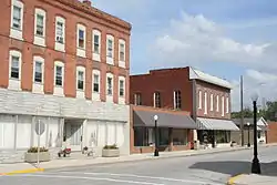
Bethalto, Illinois
Bethalto is a village located in Madison County, Illinois, United States. Bethalto, like the rest of Madison County, is part of the Illinois Metro East portion of the Greater St. Louis metropolitan area. The population of Bethalto was 9,521 at the 2010 census.[3]
Bethalto | |
|---|---|
 | |
 Location of Bethalto in Madison County, Illinois. | |
.svg.png.webp) Location of Illinois in the United States | |
| Coordinates: 38°54′15″N 90°2′48″W | |
| Country | United States |
| State | Illinois |
| County | Madison |
| Government | |
| • Mayor | Alan Winslow |
| Area | |
| • Total | 7.62 sq mi (19.73 km2) |
| • Land | 7.57 sq mi (19.61 km2) |
| • Water | 0.05 sq mi (0.13 km2) |
| Population (2010) | |
| • Total | 9,521 |
| • Estimate (2019)[2] | 9,210 |
| • Density | 1,216.64/sq mi (469.75/km2) |
| Time zone | UTC-6 (CST) |
| • Summer (DST) | UTC-5 (CDT) |
| Area code(s) | 618 |
| FIPS code | 17-05599 |
| Wikimedia Commons | Bethalto, Illinois |
| Website | bethalto |
Geography
Bethalto is located at 38°54′15″N 90°2′48″W (38.904197, -90.046579).[4]
According to the 2010 census, Bethalto has a total area of 7.6 square miles (19.68 km2), of which 7.52 square miles (19.48 km2) (or 98.95%) is land and 0.08 square miles (0.21 km2) (or 1.05%) is water.[5]
History
Bethalto was founded in 1834, incorporated April 19, 1869, under a special charter and again in 1873 under the State of Illinois' general law. It is governed by a Village President and six trustees elected at large.[6]
The original name of Bethalto was Bethel. However, when the first post office was established, it was discovered that there was already a Bethel, Illinois. There is a general consensus that the name "Bethalto" came from the first four letters of Bethel and the first four letters of nearby Alton.[7]
The Bethalto Village Hall is listed on the National Register of Historic Places.
Demographics
| Historical population | |||
|---|---|---|---|
| Census | Pop. | %± | |
| 1880 | 628 | — | |
| 1890 | 879 | 40.0% | |
| 1900 | 477 | −45.7% | |
| 1910 | 447 | −6.3% | |
| 1920 | 471 | 5.4% | |
| 1930 | 687 | 45.9% | |
| 1940 | 1,207 | 75.7% | |
| 1950 | 2,115 | 75.2% | |
| 1960 | 3,235 | 53.0% | |
| 1970 | 7,074 | 118.7% | |
| 1980 | 8,630 | 22.0% | |
| 1990 | 9,507 | 10.2% | |
| 2000 | 9,454 | −0.6% | |
| 2010 | 9,521 | 0.7% | |
| 2019 (est.) | 9,210 | [2] | −3.3% |
| U.S. Decennial Census[8] | |||
As of the census[9] of 2000, there were 9,454 people, 3,810 households, and 2,647 families residing in the village. The population density was 1,437.3 people per square mile (554.7/km2). There were 4,007 housing units at an average density of 609.2 per square mile (235.1/km2). The racial makeup of the village was 97.84% White, 0.76% African American, 0.22% Native American, 0.40% Asian, 0.33% from other races, and 0.44% from two or more races. Hispanic or Latino of any race were 1.00% of the population.
There were 3,810 households, out of which 34.1% had children under the age of 18 living with them, 54.2% were married couples living together, 11.7% had a female householder with no husband present, and 30.5% were non-families. 26.8% of all households were made up of individuals, and 12.5% had someone living alone who was 65 years of age or older. The average household size was 2.46 and the average family size was 2.98.
In the village, the population was spread out, with 25.7% under the age of 18, 8.5% from 18 to 24, 28.7% from 25 to 44, 22.9% from 45 to 64, and 14.1% who were 65 years of age or older. The median age was 37 years. For every 100 females, there were 91.3 males. For every 100 females age 18 and over, there were 85.0 males.
The median income for a household in the village was $42,201, and the median income for a family was $50,764. Males had a median income of $41,512 versus $22,981 for females. The per capita income for the village was $18,697. About 6.5% of families and 9.2% of the population were below the poverty line, including 13.1% of those under age 18 and 6.4% of those age 65 or over.[10]
Business and industry
As a bedroom community, Bethalto is home to a branch of RF Technologies, North America's largest independent service center for drive-through communication systems; and West Star Aviation, an aircraft servicing and manufacturing company located at the St. Louis Regional Airport, Bethalto Community Unit School District 8 and the Bethalto Public Library. Local restaurants include Geno's 140 Club, The Eagle's Nest, El Mezcal, and Roma's Pizza.
In late October 2006, the segment of four-lane, controlled-access Illinois Route 255 (an extension of Interstate 255) between Illinois Route 143 and Fosterburg Road was opened.[11] This highway provides Bethalto residents with convenient access to the area's freeway system and provides greater through traffic to further economic development for the region.
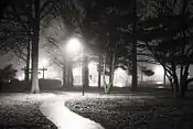
Parks and recreation
Bethalto Municipal Park
The main park in Bethalto consists of a stage amphitheater, lighted tennis courts, baseball fields, skateboard park (closed), and a newly re-modeled basketball court. The Bethalto Homecoming is held at the park every year. The park is located in the center of town, directly adjacent to the village hall.
Bethalto Arboretum
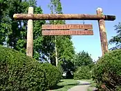
The Bethalto Arboretum is an arboretum on the east end of town that was developed in 1966 after the demise of the railroad era in Bethalto. It is one of the few arboretums in the area. A directory of trees and bushes contained in the arboretum may be viewed in the mayor and clerk's offices. There are also many plaques, in memory of Bethalto's notable persons, placed next to many of the trees in the park. The park is centered on a road truck (Rail Wheels) on top of a short slab of railroad track. The short piece of track remains in its original position as part of the old railroad tracks that existed to transport coal to and from the area.
Steve Bryant Park

Known as Culp Lane Park until 2014, it is on the northwest end of town. Features include a fishing lake, a children's play area, walking paths, pavilions, a playground, and stretches of attractive landscaping. The park was named for former mayor Steve Bryant, who was instrumental in transforming the town lagoon into a family park.
Bethalto Sports Complex

The Bethalto Sports Complex is located on the north side of town just off Culp Lane. The complex was completed in 2006 and is made up of two baseball fields, two softball fields, two soccer fields, a grandstand, and a concession stand. The complex, which is maintained by the Village of Bethalto, replaced the old baseball and soccer fields located at Civic Memorial High School for varsity and junior varsity baseball, softball and soccer teams. The Indians, the Bethalto Legion team, also calls the complex home.
Khoury League Diamonds
The Bethalto Khoury League Diamonds are located on the south side of town in the Chateaux residential area. The complex consists of four lighted diamonds with a concession stand in the center. The fields are primarily set up to handle all of the local Boys & Girls Clubs of America youth baseball and softball games. The fields are also home to a number of private and select league baseball teams that play there every summer.[6]
Schools
Bethalto Unit Schools are the largest employer in Bethalto and have the greatest impact in terms of land area and government spending. The school district, Bethalto Unit School District 8 (BCUSD8), is made up of two intermediate schools, three primary schools, one middle school, one high school, a special needs school, an administration building, and an industrial complex.
The list of schools and links to their respective website are as follows:
- Bethalto Community Unit School District 8
- Civic Memorial High School (Wiki)
- Trimpe Middle School 6th, 7th, 8th
- Bethalto East Primary School K & 1st
- Parkside Primary School 2nd & 3rd
- Meadowbrook Intermediate School 4th & 5th
- Bethalto University
Two private schools serving kindergarten through eighth grade are in Bethalto:
Religious organizations
Bethalto is home to a number of religious organizations, consisting of both small and large congregations.
The churches in Bethalto are listed here in alphabetical order:[6]
- Assembly of God
- Bethalto United Methodist
- Bethalto United Presbyterian
- Bible Baptist Church
- Church of God
- Church of the Nazarene (IL District Office)
- Conerstone Church
- Concordia Lutheran
- Cottage Hills Baptist Church
- First Baptist Church
- First Church of God
- First Christian Church
- First Southern Baptist Church
- Grace Community Church
- Heart's Harvest
- Landmark Worship Center
- Lifebrook Church
- Meadowbrook Assembly of God
- Metro Presbyterian Church
- Our Lady Queen of Peace
- Riverbend Calvary Chapel
- Skyline Church - Bethalto Campus
- St. Paul's United Methodist
- Zion Lutheran
References
- "2019 U.S. Gazetteer Files". United States Census Bureau. Retrieved July 14, 2020.
- "Population and Housing Unit Estimates". United States Census Bureau. May 24, 2020. Retrieved May 27, 2020.
- "Profile of General Population and Housing Characteristics: 2010 Demographic Profile Data (DP-1): Bethalto village, Illinois". United States Census Bureau. Retrieved January 23, 2012.
- "US Gazetteer files: 2010, 2000, and 1990". United States Census Bureau. 2011-02-12. Retrieved 2011-04-23.
- "G001 - Geographic Identifiers - 2010 Census Summary File 1". United States Census Bureau. Archived from the original on 2020-02-13. Retrieved 2015-08-02.
- Bethalto Village Brochure Archived 2011-05-23 at the Wayback Machine Retrieved March 5, 2011.
- Bethalto Library Town History Retrieved on July 3, 2007.
- "Census of Population and Housing". Census.gov. Retrieved June 4, 2015.
- "U.S. Census website". United States Census Bureau. Retrieved 2008-01-31.
- "Description of Illinois". Illinois.com Inc. Archived from the original on 2011-07-13. Retrieved March 6, 2011.
- Kapiolani Saxton, J. (2006, October 21). Another 7.6 miles is added to Interstate 255. Belleville News-Democrat (IL), retrieved July 7, 2007, from EBSCO Newspaper Source database.
External links
| Counties | 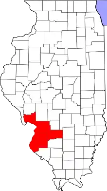 | |
|---|---|---|
| Major Cities (25,000+) | ||
| Cities (5,000-25,000) | ||
| Communities (1,000-5,000) |
| |
| Interstates | ||
| Airports | ||
| Colleges | ||
| Sports teams |
| |
Municipalities and communities of Madison County, Illinois, United States | ||
|---|---|---|
| Cities | Map of Illinois highlighting Madison County | |
| Villages | ||
| Townships | ||
| CDPs | ||
| Other unincorporated communities | ||
| Footnotes | ‡This populated place also has portions in an adjacent county or counties | |
| ||
| Counties |  | |
|---|---|---|
| Mid-sized cities (25,000+) | ||
| Small Cities (10,000-25,000) | ||
| Small Cities (5,000-10,000) | ||
| Interstates | ||
| Airports/Military bases |
| |
| Universities | ||
| Colleges | ||
| Sports teams based in the Southern Illinois | ||
| Authority control |
|---|