Bozyazı
Bozyazı is a town and district of Mersin Province on the Mediterranean coast of Turkey, 220 km (137 mi) west of the city of Mersin.
Bozyazı | |
|---|---|
District | |
.jpg.webp) | |
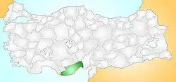 Location of Bozyazı within Turkey. | |
 Bozyazı Location of Bozyazı | |
| Coordinates: 36°06′N 32°58′E | |
| Country | |
| Region | Mediterranean |
| Province | Mersin |
| Government | |
| • Mayor | Mehmet Ballı (MHP) |
| Area | |
| • District | 565.75 km2 (218.44 sq mi) |
| Population (2012)[2] | |
| • Urban | 15,861 |
| • District | 26,557 |
| • District density | 47/km2 (120/sq mi) |
| Time zone | UTC+2 (EET) |
| • Summer (DST) | UTC+3 (EEST) |
| Postal code | 33xxx |
| Area code(s) | (0090)+ 324 |
| Licence plate | 33 |
| Website | www |
Geography
Bozyazı is a remote coastal district with the Taurus Mountains as a backdrop; The roads over the mountains or along the coast from either direction are very difficult to drive making Bozyazı too far from large cities or the established centres of tourism to attract many visitors, so the district is quiet and unspoilt. However there are developments of holiday flats in some places, mainly owned by people from Konya and Ankara as well as foreigners. The sea is clean and Bozyazı is home to an important colony of the endangered Mediterranean monk seal.
The narrow coastal strip has a temperate climate and is used to grow bananas along with strawberries, citrus fruits, ground-nuts, and a variety vegetables and fruits. The higher land (over 50% of the district) meanwhile is used for apples and walnuts. There are areas of cedar and fir trees.
The highest peaks are Tol Dağı (1,250 m), Azıtepe (780 m), Susmak Dağı (1,600 m), Kaş Dağı (1,639 m) and Elmakuzu Dağı (1,690 m), there are areas of high meadow in these mountains used for summer grazing. Bozyazı river rushes off Elmakız through a rocky gorge, there is a dam and hyrodelectric power station 14 km north of Bozyazı.
About 60% of the population lives in the town of Bozyazı, a small town providing high schools and healthcare to the surrounding villages. There are two other small towns (Tekmen and Tekeli) and about 40 villages. The biggest village is Karaisali. These are quiet places where the people are conservative; old and young spend the evenings sitting by the sea spitting out sunflower and pumpkin seeds; there is little nightlife, maybe the odd restaurant with a piano player.
History
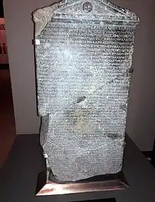
The ruins of the ancient Greek city of Nagidos are on a hill above the town of Bozyazı. They are being excavated by a team from Mersin University who have found traces of occupation going back to the Hellenistic period of the 4th century BC, when Nagidos was an outpost of Rhodes and Samos, a small port established to trade goods from Egypt and Cyprus. The town was subsequently controlled by Ptolemaic Empire, Ancient Romans, Byzantines, Cilician Armenia and Seljuk Turks.
References
- "Area of regions (including lakes), km²". Regional Statistics Database. Turkish Statistical Institute. 2002. Retrieved 2013-03-05.
- "Population of province/district centers and towns/villages by districts - 2012". Address Based Population Registration System (ABPRS) Database. Turkish Statistical Institute. Retrieved 2013-02-27.
External links
- District governor's official website (in Turkish)
- District municipality's official website (in Turkish)
- Bozyazı
- Mersin gezilecek yerler
- People Of Bozyazı
Bozyazı in Mersin Province of Turkey | |||||||||||||||||||||||||||
|---|---|---|---|---|---|---|---|---|---|---|---|---|---|---|---|---|---|---|---|---|---|---|---|---|---|---|---|
| Districts | 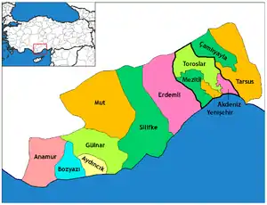 Districts of Mersin | ||||||||||||||||||||||||||
| |||||||||||||||||||||||||||
Metropolitan municipalities are bolded. | |||||||||||||||||||||||||||