Cappel, Moselle
Cappel (German: Cappel) is a commune in the Moselle department in Grand Est in north-eastern France.
Cappel | |
|---|---|
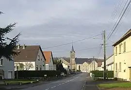 The Rue de la Libération and church in Cappel | |
.svg.png.webp) Coat of arms | |
Location of Cappel 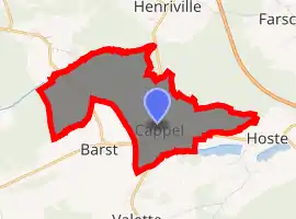
| |
 Cappel  Cappel | |
| Coordinates: 49°04′23″N 6°51′02″E | |
| Country | France |
| Region | Grand Est |
| Department | Moselle |
| Arrondissement | Forbach-Boulay-Moselle |
| Canton | Freyming-Merlebach |
| Intercommunality | Communauté de communes de Freyming-Merlebach |
| Government | |
| • Mayor (2008–2014) | Hubert Bur |
| Area 1 | 5.97 km2 (2.31 sq mi) |
| Population | 701 |
| • Density | 120/km2 (300/sq mi) |
| Time zone | UTC+01:00 (CET) |
| • Summer (DST) | UTC+02:00 (CEST) |
| INSEE/Postal code | 57122 /57450 |
| Elevation | 232–301 m (761–988 ft) (avg. 297 m or 974 ft) |
| 1 French Land Register data, which excludes lakes, ponds, glaciers > 1 km2 (0.386 sq mi or 247 acres) and river estuaries. | |
The village is situated on the N56 road.
See also
| Wikimedia Commons has media related to Cappel (Moselle). |
References
- "Populations légales 2017". INSEE. Retrieved 6 January 2020.
| Authority control |
|
|---|
This article is issued from Wikipedia. The text is licensed under Creative Commons - Attribution - Sharealike. Additional terms may apply for the media files.