Langatte
Langatte (German: Langd, Lorraine Franconian Lan(g)d), German Landbach is a commune in the Moselle department in Grand Est in north-eastern France. In 1805 it was the site of the Battle of Landbach between the French and the anti French coalition.
Langatte | |
|---|---|
_mairie.jpg.webp) The town hall in Langatte | |
.svg.png.webp) Coat of arms | |
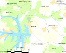
Location of Langatte 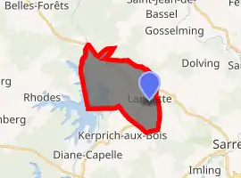
| |
 Langatte  Langatte | |
| Coordinates: 48°45′24″N 6°58′54″E | |
| Country | France |
| Region | Grand Est |
| Department | Moselle |
| Arrondissement | Sarrebourg-Château-Salins |
| Canton | Sarrebourg |
| Intercommunality | Sarrebourg - Moselle Sud |
| Government | |
| • Mayor (2008–2014) | Bernard Simon |
| Area 1 | 12.97 km2 (5.01 sq mi) |
| Population (2017-01-01)[1] | 559 |
| • Density | 43/km2 (110/sq mi) |
| Time zone | UTC+01:00 (CET) |
| • Summer (DST) | UTC+02:00 (CEST) |
| INSEE/Postal code | 57382 /57400 |
| Elevation | 256–307 m (840–1,007 ft) (avg. 260 m or 850 ft) |
| 1 French Land Register data, which excludes lakes, ponds, glaciers > 1 km2 (0.386 sq mi or 247 acres) and river estuaries. | |
Langatte is located in Southeastern Moselle near Sarrebourg. It is one of the communes who share the Étang du Stock (a pond) with Kerprich-aux-Bois, Diane-Capelle, Rhodes and Fribourg. A leisure centre and a campsite have been installed near of the pond. The new LGV Est part connecting Baudrecourt (where the High Speed Line ended before 2016) and Vendenheim has been built in Southern Moselle including Langatte and since 2016, TGV trains pass by here every day to connect Strasbourg, Paris and other destinations around France and Germany.
Notable people
References
- "Populations légales 2017". INSEE. Retrieved 6 January 2020.
| Authority control |
|
|---|