Siersthal
Siersthal (French pronunciation: [siʁstal]; Lorraine Franconian: Siirschel) is a commune in the Moselle department of the Grand Est administrative region in north-eastern France.
Siersthal | |
|---|---|
 | |
 Coat of arms | |
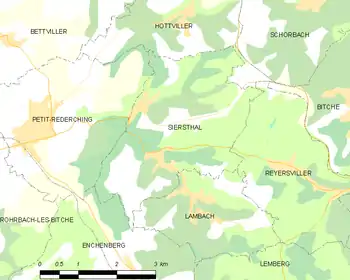
Location of Siersthal 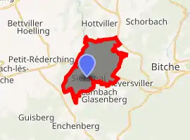
| |
 Siersthal  Siersthal | |
| Coordinates: 49°02′39″N 7°20′57″E | |
| Country | France |
| Region | Grand Est |
| Department | Moselle |
| Arrondissement | Sarreguemines |
| Canton | Bitche |
| Intercommunality | CC du Pays de Bitche |
| Government | |
| • Mayor (2020–2026) | Daniel Zintz |
| Area 1 | 10.51 km2 (4.06 sq mi) |
| Population (2017-01-01)[1] | 665 |
| • Density | 63/km2 (160/sq mi) |
| Time zone | UTC+01:00 (CET) |
| • Summer (DST) | UTC+02:00 (CEST) |
| INSEE/Postal code | 57651 /57410 |
| Elevation | 258–403 m (846–1,322 ft) (avg. 215 m or 705 ft) |
| 1 French Land Register data, which excludes lakes, ponds, glaciers > 1 km2 (0.386 sq mi or 247 acres) and river estuaries. | |
The village belongs to the Pays de Bitche and to the Northern Vosges Regional Nature Park. It is 10 kilometres (6.2 mi) away from the Franco-German border.
Geography
The area of Siersthal is 10.5 square kilometres (4.1 sq mi), population density is 63.1 inhabitants per square kilometre (163/sq mi).
The map below shows the location of Siersthal with key infrastructure and adjacent municipalities.
Population
| Year | Pop. | ±% p.a. |
|---|---|---|
| 1968 | 591 | — |
| 1975 | 592 | +0.02% |
| 1982 | 656 | +1.48% |
| 1990 | 673 | +0.32% |
| 1999 | 694 | +0.34% |
| 2007 | 653 | −0.76% |
| 2012 | 638 | −0.46% |
| 2017 | 665 | +0.83% |
| Source: INSEE[2] | ||
References
- "Populations légales 2017". INSEE. Retrieved 6 January 2020.
- Population en historique depuis 1968, INSEE
| Authority control |
|
|---|
This article is issued from Wikipedia. The text is licensed under Creative Commons - Attribution - Sharealike. Additional terms may apply for the media files.