Montbronn
Montbronn (German: Mombronn, Lorraine Franconian: Mumere) is a commune in the Moselle department of the Grand Est administrative region in north-eastern France.
Montbronn | |
|---|---|
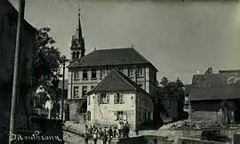 Village view | |
 Coat of arms | |
Location of Montbronn 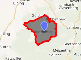
| |
 Montbronn  Montbronn | |
| Coordinates: 48°59′42″N 7°18′38″E | |
| Country | France |
| Region | Grand Est |
| Department | Moselle |
| Arrondissement | Sarreguemines |
| Canton | Bitche |
| Intercommunality | CC du Pays de Bitche |
| Government | |
| • Mayor (2020–2026) | Manuel Mayer |
| Area 1 | 14.99 km2 (5.79 sq mi) |
| Population (2017-01-01)[1] | 1,630 |
| • Density | 110/km2 (280/sq mi) |
| Time zone | UTC+01:00 (CET) |
| • Summer (DST) | UTC+02:00 (CEST) |
| INSEE/Postal code | 57477 /57415 |
| Elevation | 238–381 m (781–1,250 ft) (avg. 360 m or 1,180 ft) |
| Website | montbronn |
| 1 French Land Register data, which excludes lakes, ponds, glaciers > 1 km2 (0.386 sq mi or 247 acres) and river estuaries. | |
The village belongs to the Pays de Bitche and to the Northern Vosges Regional Nature Park. As of 2017, the village's population is 1,630. The inhabitants of the commune are known as Montbronnois or Montbronnoises.
Geography
Location
Located east of the Moselle department, the commune is part of the Pays de Bitche; It borders the neighboring Bas-Rhin department, a territory also known as Alsace bossue.[2]
The village is located 11 kilometres (6.8 mi) south-west of Bitche, the county's chief town, 21.8 kilometres (13.5 mi) south-east of Sarreguemines, the arrondissement's subprefecture, about 83 kilometres (52 mi) east of Metz, the department's prefecture and about 56 kilometres (35 mi) north-west of Strasbourg, the region's prefecture.[3] Neighboring communes include Rahling to the west, Bining, Rohrbach-lès-Bitche and Enchenberg to the north, Saint-Louis-lès-Bitche and Meisenthal to the east, and Soucht to the south.[4]
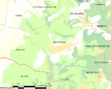
Neighbouring communes and villages[5]
Places adjacent to Montbronn | |
|---|---|
Road network
The town is crossed from west to east (Main Street) by the D83 which connects Kalhausen to Enchenberg. This road crosses both the D110F and the D36A in the village, linking it to respectively Rohrbach-lès-Bitche and Lemberg. Thoses roads are later extended by several county roads. The nearest entrance to the Autoroute de L'Est (A4 autoroute) is via the D83 through the Sarre-Union interchange at Thal-Drulingen.[2] · [5]
Public transport
The Sarreguemines–Bitche railway line has passed through the neighboring commune of Enchenberg from 1869 to 2014. The railway line is now disused and has been replaced by a TER Lorraine bus line. Today, the nearest SNCF station is in Diemeringen, commune served by the Sarreguemines–Strasbourg railway line.[6]
School buses to the Lemberg collège (middle school) and to the collèges and lycées (middle and high schools) of Bitche are available during school terms.[7]
Administration
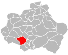
Canton and intercommunality
Montbronn is one of 46 communes in the canton of Bitche. Its general counsels since the French legislative election of 2012 are Anne Mazuy-Harter (DVD) and David Suck (UDI).[8]
The town is part of the Pays de Bitche federation of municipalities which as of January 1, 2017 consists of the same 46 communes as the canton. This grouping is headed by Francis Vogt, municipal counsel of Bitche.[4] · [9]
List of successive mayors
| From | To | Name | Party | Position |
|---|---|---|---|---|
| 1977 | 2020 | Francis Sidot | independent | |
| 2020 | 2026 | Manuel Mayer |
(Not all data is known)
Population
In 2017 the commune had 1,630 inhabitants.
|
| ||||||||||||||||||||||||||||||||||||||||||||||||||||||||||||||||||||||||||||||||||||||||||||||||||||||
| Source: EHESS[10] and INSEE[11] | |||||||||||||||||||||||||||||||||||||||||||||||||||||||||||||||||||||||||||||||||||||||||||||||||||||||
Local life
Language
The majority of the inhabitants can speak and/or understand German and also speak French. The local dialect is known as Lorraine Franconian. Lorraine Franconian is a dialect of German that has been spoken and developed in the region for over a thousand years.[12]
Education
Montbronn depends on the Academy of Nancy-Metz.
The village is provided with a preschool (French: école maternelle) and a primary school (French: école primaire).[13]
Studies then go on at the collège La Paraison in Lemberg. To pursue their studies in high school, young Montbronnois mainly go to Bitche or Sarreguemines.
See also
Bibliography
- Beck, Joël (1988). Rohrbach-lès-Bitche et son canton (in French) (Éditions Pierron ed.). Sarreguemines.
- Beck, Joël (1999). Moulins : huileries, tailleries, scieries du pays de Bitche (in French) (Éditions Pierron ed.). Sarreguemines.
- Beck, Joël (2004). Le canton de Rohrbach-lès-Bitche (in French) (Éditions Sutton ed.).
- Beck, Joël (2005). Le Pays de Bitche 1900-1939 (in French) (Éditions Sutton ed.).
- Conrad, Joseph (2000). Jung, Peter (ed.). Les habitants de Montbronn (in French).
- Glath, Paul-Édouard (1997). Du pays de Bitche en Charente-Maritime : Souvenirs de 1939-40 (in French).
- Jacops, Marie-France; Guillaume, Jacques; Hemmert, Didier (1998). Le Pays de Bitche (Moselle) (in French) (Éditions Serpenoise ed.). Metz. pp. 81–82.
- Kochert, Francis; Michaux, Laurette; Michaux, Gérard (2008). Moselle : Metz et le pays messin, pays de Bitche, Nied, Sarrebourg, Saulnois, trois frontières et bassin houiller (in French).
- Marcus, Adolphe (1887). Les verreries du comté de Bitche [essai historique] (in French) (imprimerie de Berger-Levrault ed.). Nancy. pp. 155–156.
- Mazerang, Albert (2013). Les cloches de Montbronn (in French).
- Charpentier, Nöelle-Vix (2011). Plan local d'urbanisme de Montbronn [Rapport de présentation] (PDF) (in French). Metz. Archived from the original (PDF) on 2016-05-31. Retrieved 2016-05-11.
- Schaefer, Joseph (2004). Le Pays de Bitche, passionnément (in French).
- Schutz, André (1992). Bitche et son pays (in French).
Related articles
References
- "Populations légales 2017". INSEE. Retrieved 6 January 2020.
- (Charpentier 2011, p. 9).
- "Orthodromy". Lion1906 from Lionel Delvarre. Retrieved 21 March 2016.
- (Charpentier 2011, p. 11).
- Google Maps
- "TER Lorraine". SNCF's website. Retrieved 21 March 2016.
- "School buses". cg57.fr. Archived from the original on 16 August 2016. Retrieved 21 March 2016.
- "County Council". moselle.fr. Retrieved 21 March 2016.
- "The community of communes's elected representatives". Pays de Bitche community of communes's website. Archived from the original on 10 March 2016. Retrieved 21 March 2016.
- Des villages de Cassini aux communes d'aujourd'hui: Commune data sheet Montbronn, EHESS. (in French)
- Population en historique depuis 1968, INSEE
- S. Legrand - according to the INSEE's numbers.
- "Montbronn's public preschool". education.gouv.fr. Retrieved 7 May 2016.
- "Montbronn's general practitioners". doctolib.fr. Retrieved 18 May 2016.
- "The Montbronn medical home's opening". republicain-lorrain.fr. Retrieved 18 May 2016.
- "Montbronn's pharmacy". Pages Jaunes's website. Retrieved 18 May 2016.
- "Nearest hospitals from Montbronn". medecin-360.fr. Retrieved 18 May 2016.
External links
- "Official website" (in French).
- "Montbronn". annuaire-mairie.fr (in French).
- "Montbronn". bitscherland.fr (in French).
- "Montbronn". geneawiki.com (in French).
| Authority control |
|---|