Roppeviller
Roppeviller (German: Roppweiler, Lorraine Franconian: Roppwiller) is a commune in the Moselle department of the Grand Est administrative region in north-eastern France.
Roppeviller | |
|---|---|
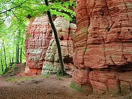 The Altschloss | |
 Coat of arms | |
Location of Roppeviller 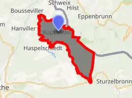
| |
 Roppeviller  Roppeviller | |
| Coordinates: 49°06′10″N 7°30′34″E | |
| Country | France |
| Region | Grand Est |
| Department | Moselle |
| Arrondissement | Sarreguemines |
| Canton | Bitche |
| Intercommunality | CC du Pays de Bitche |
| Government | |
| • Mayor (2008–2014) | René Braunecker |
| Area 1 | 13.77 km2 (5.32 sq mi) |
| Population (2017-01-01)[1] | 105 |
| • Density | 7.6/km2 (20/sq mi) |
| Time zone | UTC+01:00 (CET) |
| • Summer (DST) | UTC+02:00 (CEST) |
| INSEE/Postal code | 57594 /57230 |
| Elevation | 257–451 m (843–1,480 ft) (avg. 260 m or 850 ft) |
| 1 French Land Register data, which excludes lakes, ponds, glaciers > 1 km2 (0.386 sq mi or 247 acres) and river estuaries. | |
The village belongs to the Pays de Bitche and to the Northern Vosges Regional Nature Park.
A path from the village runs up to the Altschlossfelsen rocks, a popular walking destination, on the hill of Brechenberg on the German side of the border.
References
- "Populations légales 2017". INSEE. Retrieved 6 January 2020.
| Authority control |
|---|
This article is issued from Wikipedia. The text is licensed under Creative Commons - Attribution - Sharealike. Additional terms may apply for the media files.